
Bulloo Downs, Queensland
Suburb of Shire of Bulloo, Queensland, Australia / From Wikipedia, the free encyclopedia
Bulloo Downs is a rural locality in the Shire of Bulloo, Queensland, Australia.[2] It is on the Queensland border with New South Wales.[3] In the 2021 census, Bulloo Downs had "no people or a very low population".[1]
Quick Facts Bulloo Downs Queensland, Coordinates ...
| Bulloo Downs Queensland | |||||||||||||||
|---|---|---|---|---|---|---|---|---|---|---|---|---|---|---|---|
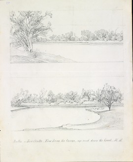 Sketch of Bulloo River area near the Kooliatto Waterhole, 1861 by Hermman Beckler, member of the Burke and Wills expedition | |||||||||||||||
 Bulloo Downs | |||||||||||||||
| Coordinates | 28.6023°S 142.8123°E / -28.6023; 142.8123 (Bulloo Downs (centre of locality)) | ||||||||||||||
| Population | 0 (2021 census)[1] | ||||||||||||||
| • Density | 0.00000/km2 (0.00000/sq mi) | ||||||||||||||
| Postcode(s) | 4492 | ||||||||||||||
| Elevation | 93 m (305 ft) | ||||||||||||||
| Area | 11,252.1 km2 (4,344.5 sq mi) | ||||||||||||||
| Time zone | AEST (UTC+10:00) | ||||||||||||||
| Location |
| ||||||||||||||
| LGA(s) | Shire of Bulloo | ||||||||||||||
| State electorate(s) | Warrego | ||||||||||||||
| Federal division(s) | Maranoa | ||||||||||||||
| |||||||||||||||
Close
On 17 April 2020 the Queensland Government reorganised the nine localities in the Shire, resulting in six localities. It included Bulloo Downs losing a portion of its western land to the locality of Cameron Corner while gaining a small portion from the south of the former Bullawarra (the rest being incorporated into Thargomindah).[4][5][6] The area of Bulloo Downs decreased from 12,814.6 square kilometres (4,947.7 sq mi) to 11,252.1 square kilometres (4,344.5 sq mi).[3]