File:2008_Sichuan_Earthquake_aftershockes_through_May_28.pdf
維基百科,自由的 encyclopedia

此PDF文件的JPG预览的大小:463 × 599像素。 其他分辨率:185 × 240像素 | 371 × 480像素 | 593 × 768像素 | 1,275 × 1,650像素。
原始文件 (1,275 × 1,650像素,文件大小:1.29 MB,MIME类型:application/pdf)
摘要
| 描述2008 Sichuan Earthquake aftershockes through May 28.pdf |
English: Map showing the location of the 2008 Sichuan earthquake and all the aftershocks following it through May 28, 2008 |
| 日期 | |
| 来源 | USGS |
| 作者 | USGS |
| 授权 (二次使用本文件) |
Public Domain |
许可协议
| Public domainPublic domainfalsefalse |
|
Bahasa Indonesia ∙ català ∙ čeština ∙ Deutsch ∙ eesti ∙ English ∙ español ∙ français ∙ galego ∙ italiano ∙ Nederlands ∙ português ∙ polski ∙ sicilianu ∙ suomi ∙ Tiếng Việt ∙ Türkçe ∙ български ∙ македонски ∙ русский ∙ മലയാളം ∙ 한국어 ∙ 日本語 ∙ 中文 ∙ 中文(简体) ∙ 中文(繁體) ∙ العربية ∙ فارسی ∙ +/− |
原始上传日志
原始描述頁面位於這裡。下列使用者名稱均來自en.wikipedia。
- 2008-06-09 20:51 Cyclonebiskit 1275×1650× (1352464 bytes) {{Information |Description=Map showing the location of the 2008 Sichuan eathquake and all the aftershocks following it through May 28, 2008 |Source=[https://earthquake.usgs.gov/eqcenter/eqinthenews/2008/us2008ryan/#summary USGS] |Date=2008-6-1 |Author=USGS
说明
添加一行文字以描述该文件所表现的内容
此文件中描述的项目
描繪內容
1 6 2008
application/pdf
1,352,464 字节
1,650 像素
1,275 像素
1
文件历史
点击某个日期/时间查看对应时刻的文件。
| 日期/时间 | 缩略图 | 大小 | 用户 | 备注 | |
|---|---|---|---|---|---|
| 当前 | 2014年4月13日 (日) 21:55 | 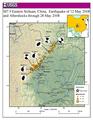 | 1,275 × 1,650(1.29 MB) | The Bushranger | Transferred from en.wikipedia |
文件用途
以下页面使用本文件:
全域文件用途
以下其他wiki使用此文件:
- en.wikipedia.org上的用途
- fi.wikipedia.org上的用途
- id.wikipedia.org上的用途
- mt.wikipedia.org上的用途
- sh.wikipedia.org上的用途
- sl.wikipedia.org上的用途
元数据
此文件中包含有扩展的信息。这些信息可能是由数码相机或扫描仪在创建或数字化过程中所添加。
如果此文件的源文件已经被修改,一些信息在修改后的文件中将不能完全反映出来。
| 使用软件 | ESRI ArcMap 9.2.4.1420 |
|---|---|
| 加密 | no |
| 页面大小 | 612 x 792 pts (letter) |
| PDF格式的版本 | 1.5 |