Settrington
Village and civil parish in North Yorkshire, England From Wikipedia, the free encyclopedia
Settrington is a village and civil parish in North Yorkshire, England, about 3 miles (5 km) east of Malton. It was historically part of the East Riding of Yorkshire until 1974 and part of the Ryedale district from 1974 until 2023.
| Settrington | |
|---|---|
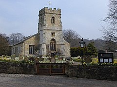
 All Saints' Church, Settrington | |
Location within North Yorkshire | |
| Population | 316 (2011 census)[1] |
| OS grid reference | SE834705 |
| Civil parish |
|
| Unitary authority | |
| Ceremonial county | |
| Region | |
| Country | England |
| Sovereign state | United Kingdom |
| Post town | MALTON |
| Postcode district | YO17 |
| Police | North Yorkshire |
| Fire | North Yorkshire |
| Ambulance | Yorkshire |
| UK Parliament | |
History
Summarize
Perspective
Settrington is mentioned in the Domesday Book of 1086 as belonging to Berengar of Tosny, and having 16 villagers, two ploughlands, and 20 acres (8.1 ha) of meadow.[2] The book lists its entry as Sendriton, and the name derives from a personal name of Old English Sǣtere and tūn meaning town.[3]
Sir Francis Bigod of Settrington launched Bigod's Rebellion against King Henry VIII in January 1537.[4] Sir Francis Bigod was hanged, drawn and quartered on Tyburn Hill on 2 June 1537.[5] His manor was granted to Matthew Stewart, Earl of Lennox and Lady Margaret Douglas by Henry VIII.[6]
Settrington was served by Settrington railway station on the Malton and Driffield Railway between 1853 and 1950.[7] The station was to the south of the village on Grimston Lane.[8]
The village has a church at the south end of the village, whilst the primary school is on the northern side.[9] The middle of Settrington is divided by the village stream; Settrington Beck.[10] An Ofsted inspection of the primary school in 2023 rated it as being Good.[11] The Church of All Saints was built in the late 12th/early 13th century, and is listed with Historic England as a grade II* structure.[12][13] Settrington Beck flows for 6.8 miles (11 km) from the south, northwards through Settrington to join the River Derwent at Scagglethorpe. There is a mill-pond on the beck at the south end of the village.[14][15]
The long-distance path, the Centenary Way passes through the village.[16]
Governance
The village and parish were historically in the wapentake of Buckrose, in the old East Riding of Yorkshire. In 1974, it was moved into the county of North Yorkshire, as part of the Ryedale District.[17][18]
| Year | 1801 | 1811 | 1821 | 1831 | 1841 | 1851 | 1861 | 1871 | 1881 | 1891 | 1901 | 1911 | 1921 | 1931 | 1951 | 1961 | 1971 | 2001 | 2011 | 2015 |
|---|---|---|---|---|---|---|---|---|---|---|---|---|---|---|---|---|---|---|---|---|
| Village | 414 | 510 | 535 | 527 | 492 | 550 | 556 | 512 | 555 | 488 | 475 | 495 | 448 | 411 | 355 | 325 | 323 | |||
| Parish | 614 | 729 | 757 | 779 | 741 | 825 | 871 | 777 | 802 | 685 | 669 | 339 | 316 | 290[note 1] |
Notes
References
External links
Wikiwand - on
Seamless Wikipedia browsing. On steroids.

