
Hibernia, New Jersey
Populated place in Morris County, New Jersey, US / From Wikipedia, the free encyclopedia
Dear Wikiwand AI, let's keep it short by simply answering these key questions:
Can you list the top facts and stats about Hibernia, New Jersey?
Summarize this article for a 10 year old
Hibernia is an unincorporated community and census-designated place (CDP)[5] located along County Route 513 (Green Pond Road) in Rockaway Township of Morris County, in the U.S. state of New Jersey.[1][6] The area is served as United States Postal Service ZIP Code 07842. The community takes its name from Hibernia, the classical name for Ireland.[7]
Hibernia, New Jersey | |
|---|---|
 View along Green Pond Road | |
 Hibernia Location in the United States Show map of the United States | |
| Coordinates: 40°56′38″N 74°29′34″W[1] | |
| Country | |
| State | |
| County | Morris |
| Township | Rockaway |
| Named for | Hibernia, the classical name for Ireland |
| Area | |
| • Total | 2.26 sq mi (5.86 km2) |
| • Land | 2.16 sq mi (5.59 km2) |
| • Water | 0.10 sq mi (0.27 km2) |
| Elevation | 538 ft (164 m) |
| Population | |
| • Total | 208 |
| • Density | 96.34/sq mi (37.19/km2) |
| ZIP Code | 07866 |
| FIPS code | 34-31170[4] |
| GNIS feature ID | 877076[1] |


As of the 2000 United States census, the population for ZIP Code Tabulation Area 07842 was 93.
The Hibernia mines, a series of iron mines worked from pre-Revolutionary times until 1916, are located here.
Since 1970, the former Methodist Episcopal Church on Green Pond Road has been used as a branch of the Rockaway Township Free Public Library.[8]
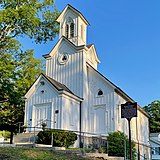 Methodist Episcopal Church, now a library
