File:Rapid_Transit_Map_of_Delhi.jpg
From Wikipedia, the free encyclopedia
Size of this preview: 800 × 576 pixels. Other resolutions: 320 × 230 pixels | 640 × 461 pixels | 1,024 × 738 pixels | 1,280 × 922 pixels | 2,560 × 1,844 pixels | 6,675 × 4,808 pixels.
Original file (6,675 × 4,808 pixels, file size: 17.08 MB, MIME type: image/jpeg)
| This is a file from the Wikimedia Commons. Information from its description page there is shown below. Commons is a freely licensed media file repository. You can help. |
Summary
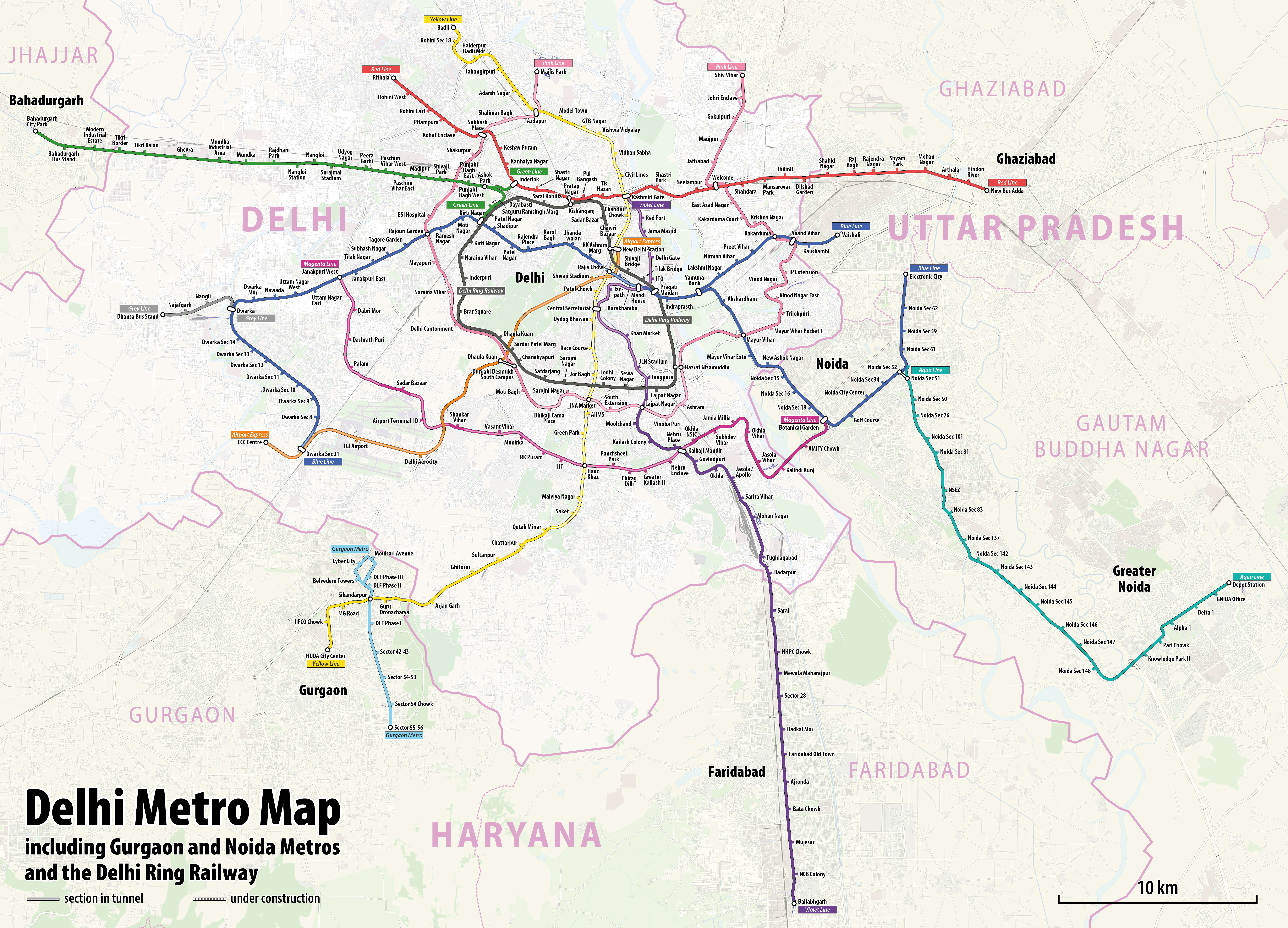
| DescriptionRapid Transit Map of Delhi.jpg |
|
| Date | see file history |
| Source | Own work using: OpenStreetMap data for the background |
| Author | Maximilian Dörrbecker (Chumwa) |
| Permission (Reusing this file) |
All OpenStreetMap data and maps are Creative Commons "CC-BY-SA 2.0" licensed This file is licensed under the Creative Commons Attribution-Share Alike 2.0 Generic license.
|
Captions
Add a one-line explanation of what this file represents
Items portrayed in this file
depicts
image/jpeg
File history
Click on a date/time to view the file as it appeared at that time.
| Date/Time | Thumbnail | Dimensions | User | Comment | |
|---|---|---|---|---|---|
| current | 12:42, 19 March 2022 | | 6,675 × 4,808 (17.08 MB) | Painjet | The section between Trilokpuri Sanjay Lake and Mayur Vihar Pocket I was opened on 6 August 2021. |
| 16:59, 19 January 2020 |  | 6,675 × 4,808 (17.27 MB) | Chumwa | == {{int:filedesc}} == {{Information |Description= *{{de|1=Linienplan der U-Bahnlinien und der Ringeisenbahn von Delhi}} *{{en|Map of the metro lines and the ring railway of Delhi}} |Author=Maximilian Dörrbecker (Chumwa) |Source={{own using}} OpenStreetMap data for the background |Date=see file history |Permission=All OpenStreetMap data and maps are Creative Commons "CC-BY-SA 2.0" licensed{{cc-by-sa-2.0}} |other_versions= }} [[Category:Public t... |
File usage
The following pages on the English Wikipedia use this file (pages on other projects are not listed):
Global file usage
The following other wikis use this file:
- Usage on azb.wikipedia.org
- Usage on be.wikipedia.org
- Usage on bn.wikipedia.org
- Usage on ca.wikipedia.org
- Usage on cs.wikipedia.org
- Usage on de.wikipedia.org
- Usage on de.wikivoyage.org
- Usage on en.wikivoyage.org
- Usage on es.wikipedia.org
- Usage on fa.wikipedia.org
- Usage on fi.wikipedia.org
- Usage on fi.wikivoyage.org
- Usage on fr.wikipedia.org
- Usage on fr.wikivoyage.org
- Usage on hi.wikipedia.org
- Usage on hu.wikipedia.org
- Usage on hy.wikipedia.org
- Usage on id.wikipedia.org
- Usage on incubator.wikimedia.org
- Usage on it.wikipedia.org
- Usage on ja.wikipedia.org
- Usage on ka.wikipedia.org
- Usage on ko.wikipedia.org
- Usage on mai.wikipedia.org
- Usage on ml.wikipedia.org
- Usage on mr.wikipedia.org
- Usage on nl.wikipedia.org
- Usage on nl.wikivoyage.org
- Usage on no.wikipedia.org
- Usage on pa.wikipedia.org
- Usage on pnb.wikipedia.org
- Usage on pt.wikipedia.org
- Usage on ru.wikipedia.org
View more global usage of this file.
Metadata
This file contains additional information, probably added from the digital camera or scanner used to create or digitize it.
If the file has been modified from its original state, some details may not fully reflect the modified file.
| Short title |
|
|---|---|
| Width | 6,675 px |
| Height | 4,808 px |
| Bits per component |
|
| Pixel composition | RGB |
| Orientation | Normal |
| Number of components | 3 |
| Horizontal resolution | 96 dpi |
| Vertical resolution | 96 dpi |
| Software used | Adobe Photoshop 22.4 (Macintosh) |
| File change date and time | 20:35, 19 March 2022 |
| Exif version | 2.31 |
| Color space | Uncalibrated |
| Date metadata was last modified | 04:35, 20 March 2022 |
| Date and time of digitizing | 18:49, 19 January 2020 |
| Unique ID of original document | uuid:5D20892493BFDB11914A8590D31508C8 |
Retrieved from "https://en.wikipedia.org/wiki/File:Rapid_Transit_Map_of_Delhi.jpg"