File:Europe,_1714.png
From Wikipedia, the free encyclopedia
Size of this preview: 800 × 546 pixels. Other resolutions: 320 × 219 pixels | 640 × 437 pixels | 1,024 × 699 pixels | 1,280 × 874 pixels | 1,590 × 1,086 pixels.
Original file (1,590 × 1,086 pixels, file size: 986 KB, MIME type: image/png)
| This is a file from the Wikimedia Commons. Information from its description page there is shown below. Commons is a freely licensed media file repository. You can help. |

|
This map of europe image could be re-created using vector graphics as an SVG file. This has several advantages; see Commons:Media for cleanup for more information. If an SVG form of this image is available, please upload it and afterwards replace this template with
{{vector version available|new image name}}.
It is recommended to name the SVG file “Europe, 1714.svg”—then the template Vector version available (or Vva) does not need the new image name parameter. |
_en.png)
.png)
.jpg)
Summary
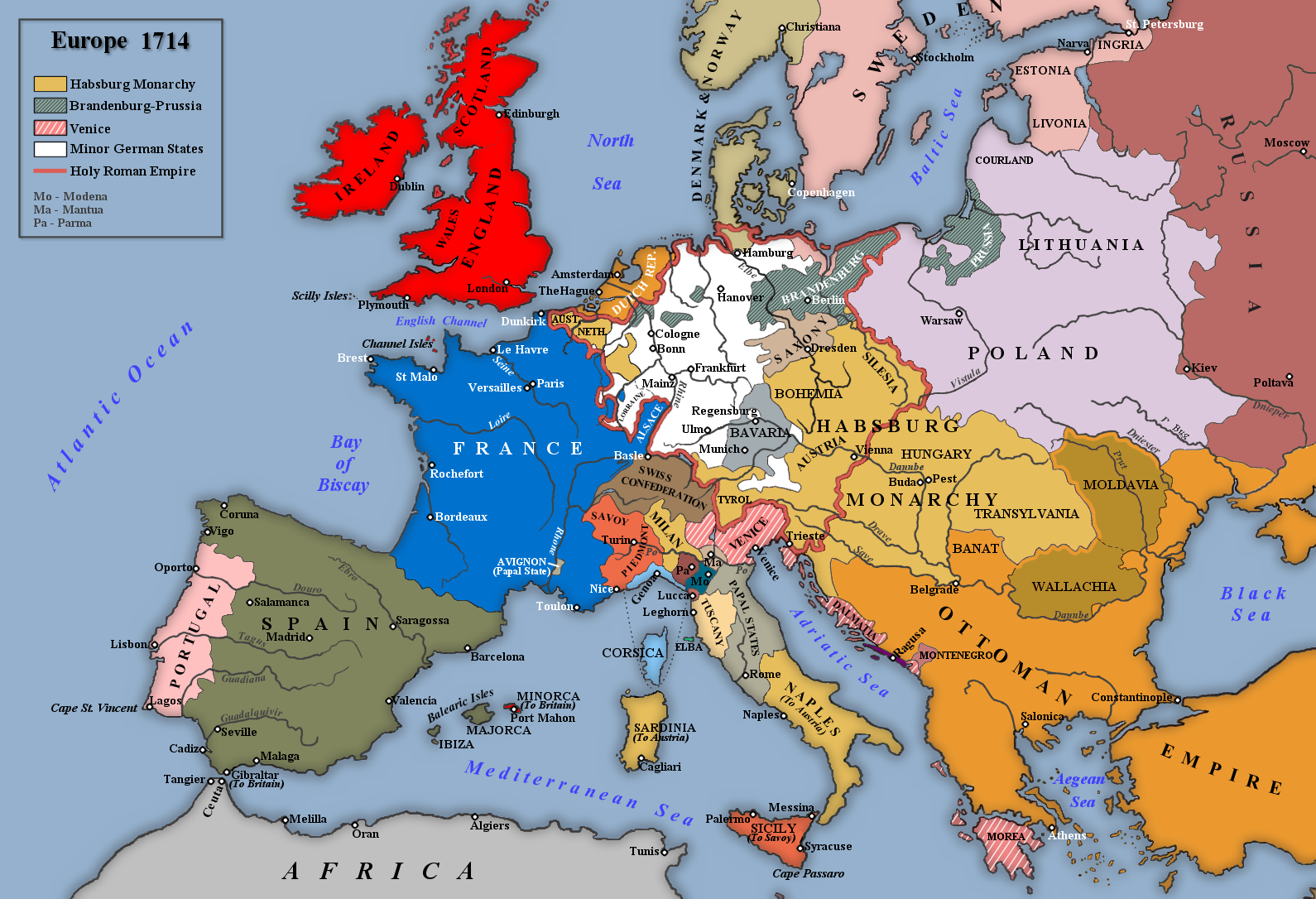
| DescriptionEurope, 1714.png |
English: Map of Europe in 1714 |
| Date | |
| Source | Own work |
| Author | Rebel Redcoat |
Licensing
| Public domainPublic domainfalsefalse |
| I, the copyright holder of this work, release this work into the public domain. This applies worldwide. In some countries this may not be legally possible; if so: I grant anyone the right to use this work for any purpose, without any conditions, unless such conditions are required by law. |
Captions
Add a one-line explanation of what this file represents
Items portrayed in this file
depicts
some value
18 June 2010
File history
Click on a date/time to view the file as it appeared at that time.
| Date/Time | Thumbnail | Dimensions | User | Comment | |
|---|---|---|---|---|---|
| current | 17:42, 2 May 2014 | | 1,590 × 1,086 (986 KB) | Spiridon Ion Cepleanu | According with H.E.Stier (dir.) Grosser Atlas zur Weltgeschichte, Westermann 1984, p.119, ISBN 3141009198, & all sources, the Danubian principalities were not turkish provinces but christian states (ruled by Greek hospodars), vassal of the Ottoman sult... |
| 19:21, 7 January 2014 |  | 1,590 × 1,086 (1.07 MB) | Rebel Redcoat~commonswiki | Some minor improvements/accuracy | |
| 11:59, 17 January 2013 |  | 1,590 × 1,086 (1.06 MB) | Rebel Redcoat~commonswiki | Added St. Petersburg | |
| 15:00, 26 May 2012 |  | 1,590 × 1,086 (1.06 MB) | Rebel Redcoat~commonswiki | Correction: Sicily | |
| 18:48, 6 May 2012 |  | 1,590 × 1,086 (1.06 MB) | Rebel Redcoat~commonswiki | Better quality | |
| 23:30, 17 June 2010 |  | 1,594 × 1,090 (222 KB) | Rebel Redcoat~commonswiki | {{Information |Description={{en|1=Map of Europe in 1714}} |Source={{own}} |Author=Rebel Redcoat |Date=18 June 2010 |Permission= |other_versions= }} Category:Maps |
File usage
The following pages on the English Wikipedia use this file (pages on other projects are not listed):
Global file usage
The following other wikis use this file:
- Usage on ar.wikipedia.org
- Usage on bg.wikipedia.org
- Usage on ca.wikipedia.org
- Usage on fa.wikipedia.org
- Usage on fr.wikipedia.org
- Usage on gcr.wikipedia.org
- Usage on id.wikipedia.org
- Usage on ja.wikipedia.org
- Usage on mk.wikipedia.org
- Usage on nl.wikipedia.org
- Usage on nn.wikipedia.org
- Usage on ru.wikipedia.org
- Usage on sh.wikipedia.org
- Usage on tr.wikipedia.org
- Usage on uk.wikipedia.org
- Usage on www.wikidata.org
Metadata
This file contains additional information, probably added from the digital camera or scanner used to create or digitize it.
If the file has been modified from its original state, some details may not fully reflect the modified file.
| Horizontal resolution | 47 dpc |
|---|---|
| Vertical resolution | 47 dpc |
Retrieved from "https://en.wikipedia.org/wiki/File:Europe,_1714.png"