更多信息 {{Infobox mountain}}, {{Infobox mountain/sandbox}} ...
关闭
更多信息 {{Infobox mountain}}, {{Infobox mountain/sandbox}} ...
关闭
更多信息 {{Infobox mountain}}, {{Infobox mountain/sandbox}} ...
左右对比| {{Infobox mountain}} | {{Infobox mountain/sandbox}} |
|---|
| K2 |
|---|
 K2 in Summer | |
| 海拔 | 8,611米(28,251英尺) Ranked 2nd |
|---|
| 地形突起度 | 4,017米(13,179英尺) |
|---|
| 坐标 | 35°52′57″N 76°30′48″E [1] |
|---|
|
Location on Pakistan/China border | | 位置 | Taxkorgan Tajik Autonomous County, Xinjiang, China/Northern Areas, Pakistan This is an example of a long line. |
|---|
| 所属山脉 | Karakoram |
|---|
|
| 首次登頂 | July 31, 1954 by Lacedelli & Compagnoni |
|---|
| 最简路线 | Rock, snow and ice climb |
|---|
|
| K2 |
|---|
 K2 in Summer | |
| 海拔 | 8,611米(28,251英尺) Ranked 2nd |
|---|
| 相對高度 | 4,017米(13,179英尺) |
|---|
| 坐标 | 35°52′57″N 76°30′48″E [1] |
|---|
|
Location on Pakistan/China border | | 位置 | Taxkorgan Tajik Autonomous County, Xinjiang, China/Northern Areas, Pakistan This is an example of a long line. |
|---|
| 山脈 | Karakoram |
|---|
|
| 首次登頂 | July 31, 1954 by Lacedelli & Compagnoni |
|---|
| 最簡路線 | Rock, snow and ice climb |
|---|
|
关闭
Label is bold
更多信息 {{Infobox mountain}}, {{Infobox mountain/sandbox}} ...
关闭
更多信息 {{Infobox mountain}}, {{Infobox mountain/sandbox}} ...
关闭
更多信息 {{Infobox mountain}}, {{Infobox mountain/sandbox}} ...
关闭
更多信息 {{Infobox mountain}}, {{Infobox mountain/sandbox}} ...
关闭
更多信息 {{Infobox mountain}}, {{Infobox mountain/sandbox}} ...
关闭
更多信息 {{Infobox mountain}}, {{Infobox mountain/sandbox}} ...
关闭
更多信息 {{Infobox mountain}}, {{Infobox mountain/sandbox}} ...
左右对比| {{Infobox mountain}} | {{Infobox mountain/sandbox}} |
|---|
| Ben Nevis |
|---|
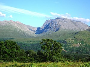 Ben Nevis from Banavie. The summit is beyond and to the left of the apparent highest point. | | 譯名 | Venomous mountain or mountain with its head in the clouds(Scottish Gaelic language) |
|---|
|
| 海拔 | 1,344米(4,409英尺) |
|---|
| 地形突起度 | 1,344米(4,409英尺)Ranked 1st in British Isles |
|---|
| 母峰 | none - HP Great Britain |
|---|
| 列表 | Munro, Marilyn, Council top (Highland), County top (Inverness-shire) |
|---|
| 坐标 | 56.796986°N 5.004784°W / 56.796986; -5.004784 |
|---|
|
| | 位置 | Lochaber,  苏格兰 苏格兰 |
|---|
| OS格網系統 | NN166713 |
|---|
| 地形圖 | OS Landranger 41, Explorer 392 |
|---|
|
| 首次登頂 | 17 August 1771, by James Robertson |
|---|
| 最简路线 | Walk |
|---|
|
| Ben Nevis |
|---|
Ben Nevis from Banavie. The summit is beyond and to the left of the apparent highest point. | |
| 海拔 | 1,344米(4,409英尺) |
|---|
| 相對高度 | 1,344米(4,409英尺) Ranked 1st in British Isles |
|---|
| 母峰 | none - HP Great Britain |
|---|
| 列表 | Munro, Marilyn, Council top (Highland), County top (Inverness-shire) |
|---|
| 坐标 | 56.796986°N 5.004784°W / 56.796986; -5.004784 |
|---|
|
| 譯名 | Venomous mountain or mountain with its head in the clouds (Scottish Gaelic language) |
|---|
|
| | OS格網系統 | NN166713 |
|---|
| 地形圖 | OS Landranger 41, Explorer 392 |
|---|
|
| 首次登頂 | 17 August 1771, by James Robertson |
|---|
| 最簡路線 | Walk |
|---|
|
关闭
更多信息 {{Infobox mountain}}, {{Infobox mountain/sandbox}} ...
左右对比| {{Infobox mountain}} | {{Infobox mountain/sandbox}} |
|---|
| Hauhungatahi |
|---|
 Composite satellite image of snow-covered Ruapehu, with Hauhungatahi visible behind it. | |
| 海拔 | 1,521米(4,990英尺)[2] |
|---|
| 地形突起度 | approx 400米(1,300英尺)[2] |
|---|
| 坐标 | 39°13′46″S 175°26′39″E |
|---|
|
| | 位置 | North Island, New Zealand |
|---|
| 地形圖 | NZTopo50-BJ34[2] |
|---|
|
| 火山島弧/帶 | Taupo Volcanic Zone |
|---|
|
| 最简路线 | Tramping from the west, starting near Erua |
|---|
|
| Hauhungatahi |
|---|
 Composite satellite image of snow-covered Ruapehu, with Hauhungatahi visible behind it. | |
| 海拔 | 1,521米(4,990英尺) [2] |
|---|
| 相對高度 | approx 400米(1,300英尺)[2] |
|---|
| 坐标 | 39°13′46″S 175°26′39″E |
|---|
|
| | 地形圖 | NZTopo50-BJ34[2] |
|---|
|
| 火山島弧/帶 | Taupo Volcanic Zone |
|---|
|
| 最簡路線 | Tramping from the west, starting near Erua |
|---|
|
关闭
更多信息 {{Infobox mountain}}, {{Infobox mountain/sandbox}} ...
关闭
更多信息 {{Infobox mountain}}, {{Infobox mountain/sandbox}} ...
左右对比| {{Infobox mountain}} | {{Infobox mountain/sandbox}} |
|---|
| Mount Fuji |
|---|
 Mt. Fuji at sunrise from Lake Kawaguchi | | 别名 | 富士山 |
|---|
|
| 海拔 | 3,776米(12,388英尺)some citation |
|---|
| 地形突起度 | 3,776米(12,388英尺)Ranked 35th |
|---|
| 列表 | Country high point
Ultra |
|---|
| 坐标 | 35°21′28.8″N 138°43′51.6″E |
|---|
|
Location of Mount Fuji in Japan | | 位置 | Chubu region, Honshu, Japan  |
|---|
|
| 山脈類型 | Stratovolcano |
|---|
| 最近噴發 | 1707 |
|---|
|
| 首次登頂 | 663 by an anonymous monk |
|---|
| 最简路线 | Hiking |
|---|
|
| Mount Fuji |
|---|
|
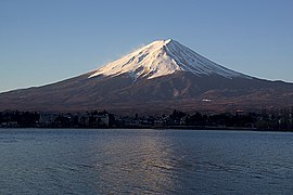 Mt. Fuji at sunrise from Lake Kawaguchi | |
| 海拔 | 3,776米(12,388英尺) some citation |
|---|
| 相對高度 | 3,776米(12,388英尺) Ranked 35th |
|---|
| 列表 | Country high point
Ultra |
|---|
| 坐标 | 35°21′28.8″N 138°43′51.6″E |
|---|
|
Location of Mount Fuji in Japan | | 位置 | Chubu region, Honshu, Japan |
|---|
|
| 山脈類型 | Stratovolcano |
|---|
| 最近噴發 | 1707 |
|---|
|
| 首次登頂 | 663 by an anonymous monk |
|---|
| 最簡路線 | Hiking |
|---|
|
关闭
更多信息 {{Infobox mountain}}, {{Infobox mountain/sandbox}} ...
左右对比| {{Infobox mountain}} | {{Infobox mountain/sandbox}} |
|---|
| Mount Baker |
|---|
 Mount Baker and Boulder Glacier from the southeast | |
| 海拔 | 10,781英尺(3,286米)[4] |
|---|
| 地形突起度 | 8,812英尺(2,686米)[4] |
|---|
| 地形孤立度 | 131英里(211公里)
to Liberty Cap[4] |
|---|
| 列表 | Ultra
List of Cascade volcanoes |
|---|
| 坐标 | 48°46′38″N 121°48′48″W [5] |
|---|
|
| 位置 | Whatcom County, Washington, USA |
|---|
| 所属山脉 | Cascade Range |
|---|
| 地形圖 | USGS Mount Baker |
|---|
|
| 岩石年代 | Less than 1 Myr |
|---|
| 火山島弧/帶 | Cascade Volcanic Arc |
|---|
| 最近噴發 | 1880 [6] |
|---|
|
| 首次登頂 | 1868 by Edmund T. Coleman and party |
|---|
| 最简路线 | snow (ice) climb |
|---|
|
| Mount Baker |
|---|
 Mount Baker and Boulder Glacier from the southeast | |
| 海拔 | 10,781英尺(3,286米) [4] |
|---|
| 相對高度 | 8,812英尺(2,686米) [4] |
|---|
| 隔离 | 131英里(211公里)
to Liberty Cap [4] |
|---|
| 列表 | Ultra
List of Cascade volcanoes |
|---|
| 坐标 | 48°46′38″N 121°48′48″W [5] |
|---|
|
| 位置 | Whatcom County, Washington, USA |
|---|
| 山脈 | Cascade Range |
|---|
| 地形圖 | USGS Mount Baker |
|---|
|
| 岩石年代 | Less than 1 Myr |
|---|
| 火山島弧/帶 | Cascade Volcanic Arc |
|---|
| 最近噴發 | 1880 [6] |
|---|
|
| 首次登頂 | 1868 by Edmund T. Coleman and party |
|---|
| 最簡路線 | snow (ice) climb |
|---|
|
关闭
Test of an infobox without a photo.
更多信息 {{Infobox mountain}}, {{Infobox mountain/sandbox}} ...
关闭
Another photo-free test case
更多信息 {{Infobox mountain}}, {{Infobox mountain/sandbox}} ...
关闭
Test rounding of elevation and prominence
更多信息 {{Infobox mountain}}, {{Infobox mountain/sandbox}} ...
左右对比| {{Infobox mountain}} | {{Infobox mountain/sandbox}} |
|---|
| Aiguille de Tré la Tête |
|---|
 View of the Aiguille de Tré la Tête | |
| 山峰 | Aiguille Centrale SE |
|---|
| 海拔 | 3,930米(12,890英尺) |
|---|
| 地形突起度 | 900米(3,000英尺)(fake) |
|---|
| 坐标 | 45°47′42″N 6°48′54″E |
|---|
|
| 位置 | Aosta Valley, Italy
(mountain partially in France) |
|---|
| 所属山脉 | Mont Blanc massif |
|---|
|
| 首次登頂 | 12 July 1864 by Anthony Adams Reilly and Edward Whymper with Michel Croz, Michel Payot and H. Charlet |
|---|
| 最简路线 | ENE arête (PD+) then the Bivouac Rainetto |
|---|
|
| Aiguille de Tré la Tête |
|---|
 View of the Aiguille de Tré la Tête | |
| 山峰 | Aiguille Centrale SE |
|---|
| 海拔 | 3,930米(12,890英尺) |
|---|
| 相對高度 | 900米(3,000英尺) (fake) |
|---|
| 坐标 | 45°47′42″N 6°48′54″E |
|---|
|
| 位置 | Aosta Valley, Italy
(mountain partially in France) |
|---|
| 山脈 | Mont Blanc massif |
|---|
|
| 首次登頂 | 12 July 1864 by Anthony Adams Reilly and Edward Whymper with Michel Croz, Michel Payot and H. Charlet |
|---|
| 最簡路線 | ENE arête (PD+) then the Bivouac Rainetto |
|---|
|
关闭
更多信息 {{Infobox mountain}}, {{Infobox mountain/sandbox}} ...
关闭
更多信息 {{Infobox mountain}}, {{Infobox mountain/sandbox}} ...
左右对比| {{Infobox mountain}} | {{Infobox mountain/sandbox}} |
|---|
|
|
| Appalachian Mountains |
|---|
|
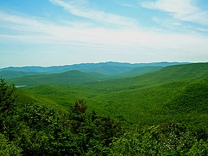
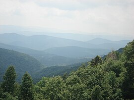 View from the slopes of Back Allegheny Mountain, looking east, in the Appalachian Mountains. Visible are Allegheny Mountain (in the Monongahela National Forest of West Virginia, middle distance) and Shenandoah Mountain (in the George Washington National Forest of Virginia, far distance). | |
| 山峰 | Mount Mitchell |
|---|
| 海拔 | 6,684英尺(2,037米) |
|---|
|
| | 国家 | United States and Canada |
|---|
| 州/省 | |
|---|
|
| 造山运动 | Taconic |
|---|
| 岩石年代 | Ordovician |
|---|
|
关闭
更多信息 {{Infobox mountain}}, {{Infobox mountain/sandbox}} ...
关闭
更多信息 {{Infobox mountain}}, {{Infobox mountain/sandbox}} ...
左右对比| {{Infobox mountain}} | {{Infobox mountain/sandbox}} |
|---|
Andes
Quechua: Anti(s/kuna) |
|---|
 | 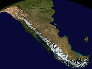 Composite satellite image of the southern Andes | |
| 山峰 | Aconcagua(Las Heras Department, Mendoza, Argentina) |
|---|
| 海拔 | 6,962米(22,841英尺) |
|---|
| 坐标 | 32°39′10″S 70°0′40″W |
|---|
|
| 长度 | 7,000公里(4,300英里) |
|---|
| 宽度 | 500公里(310英里) |
|---|
|
| 国家 | Argentina、Bolivia、Chile、Colombia、Ecuador、Peru和Venezuela |
|---|
| 聚居地 | Bogotá, Santiago, Medellín, La Paz, Cali, Quito, Pasto, Mérida, Arequipa, Mendoza, Cuenca, Cochabamba, Pereira, Ibagué, Salta, Manizales, Cúcuta, Cusco and Bucaramanga |
|---|
|
| Andes |
|---|
|
| |
| 山峰 | Aconcagua (Las Heras Department, Mendoza, Argentina) |
|---|
| 海拔 | 6,962米(22,841英尺) |
|---|
| 坐标 | 32°39′10″S 70°0′40″W |
|---|
|
| 长度 | 7,000公里(4,300英里) |
|---|
| 宽度 | 500公里(310英里) |
|---|
|
Composite satellite image of the southern Andes
| | 国家 |
- Argentina
- Bolivia
- Chile
- Colombia
- Ecuador
- Peru
- Venezuela
|
|---|
| 定居点 |
- Bogotá
- Santiago
- Medellín
- La Paz
- Cali
- Quito
- Pasto
- Mérida
- Arequipa
- Mendoza
- Cuenca
- Cochabamba
- Pereira
- Ibagué
- Salta
- Manizales
- Cúcuta
- Cusco
- Bucaramanga
|
|---|
|
关闭
更多信息 {{Infobox mountain}}, {{Infobox mountain/sandbox}} ...
左右对比| {{Infobox mountain}} | {{Infobox mountain/sandbox}} |
|---|
| Sierra Nevada |
|---|
 The Sierra's Mills Creek cirque (center) is on the west side of the Sierra Crest, south of Mono Lake (top, blue). |  Position of Sierra Nevada inside California | | 别名 | the Sierra, the High Sierra, the Sierras, Range of Light (1894, John Muir)[13] |
|---|
| 语源 | 1777: Spanish for "snowy mountain range" |
|---|
|
| 山峰 | Mount Whitney |
|---|
| 海拔 | 14,505英尺(4,421米)[17] |
|---|
| 坐标 | 36°34′43″N 118°17′31″W |
|---|
|
| 长度 | 400英里(640公里) north-south from Fredonyer Pass to Tehachapi Pass[14] |
|---|
| 宽度 | 65英里(105公里)[15] |
|---|
| 面积 | 24,370平方英里(63,100平方公里)[16] |
|---|
|
| 国家 | United States |
|---|
| 州或邦 | California和Nevada |
|---|
| 山脉坐标 | 37.73°N 119.57°W / 37.73; -119.57 |
|---|
|
| 岩石年代 | Mesozoic |
|---|
| 岩石类型 | batholith和igneous |
|---|
|
| Sierra Nevada |
|---|
The Sierra's Mills Creek cirque (center) is on the west side of the Sierra Crest, south of Mono Lake (top, blue). | |
| 山峰 | Mount Whitney |
|---|
| 海拔 | 14,505英尺(4,421米) [17] |
|---|
| 坐标 | 36°34′43″N 118°17′31″W |
|---|
|
| 长度 | 400英里(640公里) north-south from Fredonyer Pass to Tehachapi Pass [14] |
|---|
| 宽度 | 65英里(105公里) [15] |
|---|
| 面积 | 24,370平方英里(63,100平方公里) [16] |
|---|
|
| 语源 | 1777: Spanish for "snowy mountain range" |
|---|
| 昵称 | the Sierra, the High Sierra, the Sierras, Range of Light (1894, John Muir)[13] |
|---|
|
Position of Sierra Nevada inside California
| | 国家 | United States |
|---|
| 州 | California and Nevada |
|---|
| 距離坐標 | 37.73°N 119.57°W / 37.73; -119.57 |
|---|
|
| 岩石年代 | Mesozoic |
|---|
| 岩石类型 | batholith and igneous |
|---|
|
关闭
更多信息 {{Infobox mountain}}, {{Infobox mountain/sandbox}} ...
左右对比| {{Infobox mountain}} | {{Infobox mountain/sandbox}} |
|---|
| Catskill Mountains |
|---|
 Slide Mountain and the peaks around it as seen from Twin Mountain in the northern Catskills. | 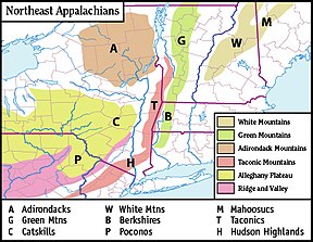 Map of the main regions of the northeast Appalachians, with the Catskills as "C". | |
| 山峰 | Slide Mountain(S of Shandaken) |
|---|
| 海拔 | 4,154英尺(1,266米) |
|---|
| 坐标 | 41°59′55″N 74°23′11″W |
|---|
|
| 长度 | 111英里(179公里) N/S |
|---|
| 宽度 | 102英里(164公里) E/W |
|---|
| 面积 | 15,259平方英里(39,520平方公里) |
|---|
|
| 国家 | United States |
|---|
| 州或邦 | New York |
|---|
| 地区 | Hudson Valley |
|---|
| Counties | Ulster, Greene, Sullivan, Delaware and Schoharie |
|---|
| Communities | Hunter, Tannersville, Monticello and Liberty |
|---|
| 所属山脉 | Appalachian |
|---|
| 边界 | Poconos and Shawangunk Ridge |
|---|
|
| 岩石年代 | Devonian和Mississippian |
|---|
| 岩石类型 | Sedimentary |
|---|
|
| Catskill Mountains |
|---|
Slide Mountain and the peaks around it as seen from Twin Mountain in the northern Catskills. | |
| 山峰 | Slide Mountain (S of Shandaken) |
|---|
| 海拔 | 4,154英尺(1,266米) |
|---|
| 坐标 | 41°59′55″N 74°23′11″W |
|---|
|
| 长度 | 111英里(179公里) N/S |
|---|
| 宽度 | 102英里(164公里) E/W |
|---|
| 面积 | 15,259平方英里(39,520平方公里) |
|---|
|
Map of the main regions of the northeast Appalachians, with the Catskills as "C".
| | 国家 | United States |
|---|
| 州 | New York |
|---|
| 區 | Hudson Valley |
|---|
| Counties |
- Ulster
- Greene
- Sullivan
- Delaware
- Schoharie
|
|---|
| Communities | Hunter, Tannersville, Monticello and Liberty |
|---|
| 山脈 | Appalachian |
|---|
| 边界 | Poconos and Shawangunk Ridge |
|---|
|
| 岩石年代 | Devonian and Mississippian |
|---|
| 岩石类型 | Sedimentary |
|---|
|
关闭
更多信息 {{Infobox mountain}}, {{Infobox mountain/sandbox}} ...
关闭
更多信息 {{Infobox mountain}}, {{Infobox mountain/sandbox}} ...
左右对比| {{Infobox mountain}} | {{Infobox mountain/sandbox}} |
|---|
| Buckskin Mountains (Arizona) |
|---|
Buckskin Mountains (Arizona) in Arizona | |
| 山峰 | Battleship Peak |
|---|
| 海拔 | 2,569英尺(783米) |
|---|
| 坐标 | 34°04′28″N 113°48′29″W |
|---|
|
| 长度 | 30英里(48公里) E-W & (SW x NE) |
|---|
|
| 国家 | United States |
|---|
| 州或邦 | Arizona |
|---|
| County | La Paz |
|---|
| Communities | Bouse, AZ and Parker Dam, CA |
|---|
| 山脉坐标 | 34°10′12.123″N 113°50′46.345″W |
|---|
| 边界 | Bill Williams & Rawhide Mountains-N
Bill Williams River-N
Butler Valley–Harcuvar Mountains-SE
Gibralter Mountain Wilderness-W
Buckskin Mountain State Park-W
Alamo Lake State Park-NE |
|---|
|
| Buckskin Mountains (Arizona) |
|---|
Buckskin Mountains (Arizona) in Arizona | |
| 山峰 | Battleship Peak |
|---|
| 海拔 | 2,569英尺(783米) |
|---|
| 坐标 | 34°04′28″N 113°48′29″W |
|---|
|
| 长度 | 30英里(48公里) E-W & (SW x NE) |
|---|
|
| 国家 | United States |
|---|
| 州 | Arizona |
|---|
| County | La Paz |
|---|
| Communities | Bouse, AZ and Parker Dam, CA |
|---|
| 距離坐標 | 34°10′12.123″N 113°50′46.345″W |
|---|
| 边界 | Bill Williams & Rawhide Mountains-N
Bill Williams River-N
Butler Valley–Harcuvar Mountains-SE
Gibralter Mountain Wilderness-W
Buckskin Mountain State Park-W
Alamo Lake State Park-NE |
|---|
|
关闭
更多信息 {{Infobox mountain}}, {{Infobox mountain/sandbox}} ...
关闭
更多信息 {{Infobox mountain}}, {{Infobox mountain/sandbox}} ...
关闭
更多信息 {{Infobox mountain}}, {{Infobox mountain/sandbox}} ...
关闭
更多信息 {{Infobox mountain}}, {{Infobox mountain/sandbox}} ...
关闭
You must specify name when using {{cite gvp}}. Sierra Nevada. Ecological Subregions of California. United States Forest Service.


