File:Sumatra_2007_earthquakes_map.gif
維基百科,自由的 encyclopedia
此为最大尺寸。
Sumatra_2007_earthquakes_map.gif (505 × 496像素,文件大小:30 KB,MIME类型:image/gif)
摘要
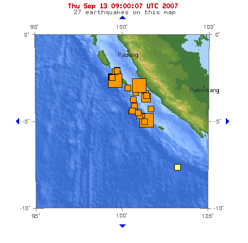
Image: This map shows the location of the 3 major earthquakes and it's many aftershocks off the coast of Sumatra on September 12 and September 13, 2007. It shows a total of 27 earthquakes, 25 of them in the last 24 hours.
Source: https://earthquake.usgs.gov/eqcenter/recenteqsww/Maps/10/100_-5.php (dynamic)
许可协议
| Public domainPublic domainfalsefalse |
|
Bahasa Indonesia ∙ català ∙ čeština ∙ Deutsch ∙ eesti ∙ English ∙ español ∙ français ∙ galego ∙ italiano ∙ Nederlands ∙ português ∙ polski ∙ sicilianu ∙ suomi ∙ Tiếng Việt ∙ Türkçe ∙ български ∙ македонски ∙ русский ∙ മലയാളം ∙ 한국어 ∙ 日本語 ∙ 中文 ∙ 中文(简体) ∙ 中文(繁體) ∙ العربية ∙ فارسی ∙ +/− |
文件历史
点击某个日期/时间查看对应时刻的文件。
| 日期/时间 | 缩略图 | 大小 | 用户 | 备注 | |
|---|---|---|---|---|---|
| 当前 | 2007年9月13日 (四) 09:53 | | 505 × 496(30 KB) | TheDJ | == Summary == '''Image:''' This map shows the location of the 3 major earthquakes and it's many aftershocks off the coast of Sumatra on September 12 and September 13, 2007. It shows a total of 27 earthquakes, 25 of them in the last 24 hours. |
文件用途
以下2个页面使用本文件:
全域文件用途
以下其他wiki使用此文件:
- de.wikipedia.org上的用途
- en.wikipedia.org上的用途
- id.wikipedia.org上的用途
- ja.wikipedia.org上的用途
- wuu.wikipedia.org上的用途