File:Panulirus_interruptus_distribution.png
維基百科,自由的 encyclopedia
此为最大尺寸。
Panulirus_interruptus_distribution.png (711 × 527像素,文件大小:67 KB,MIME类型:image/png)
| 描述Panulirus interruptus distribution.png |
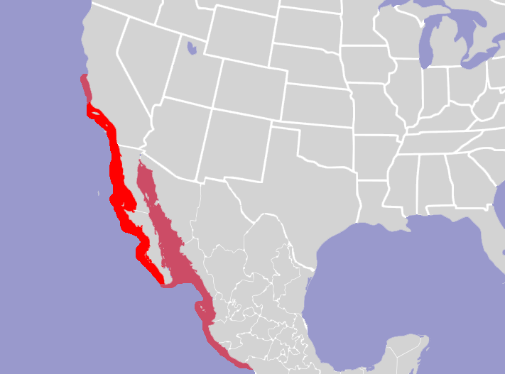
English: Map of North America and its second-level political divisions. Canadian provinces, US and Mexican states. Canada, Mexico, United States. Non-contiguous parts of a states/provinces are "grouped" together with the main area of the state/provinces, so any state/provinces can be coloured in completion with one click anywhere on the state/provinces's area. Also, all states/provinces have a "id" attached to them, making them easy to find. Select "find" and then enter in the state/provinces's ISO 3166-2 code in the "id" field to find it. The codes can be found here (Canada), here (USA) and here (Mexico). |
| 日期 | (UTC) |
| 来源 | |
| 作者 |
|
| 这是一张修改过的图片,这意味着它已在原版本的基础上通过软件进行了编辑,改动内容:Added distribution of Panulirus interruptus'。其原始版本为:North America second level political division 2.svg。修改者:Stemonitis。
|
我,本作品著作权人,特此采用以下许可协议发表本作品:
本文件采用知识共享署名-相同方式共享 2.5 通用许可协议授权。
- 您可以自由地:
- 共享 – 复制、发行并传播本作品
- 修改 – 改编作品
- 惟须遵守下列条件:
- 署名 – 您必须对作品进行署名,提供授权条款的链接,并说明是否对原始内容进行了更改。您可以用任何合理的方式来署名,但不得以任何方式表明许可人认可您或您的使用。
- 相同方式共享 – 如果您再混合、转换或者基于本作品进行创作,您必须以与原先许可协议相同或相兼容的许可协议分发您贡献的作品。
原始上传日志
This image is a derivative work of the following images:
- File:North_America_second_level_political_division_2.svg licensed with Cc-by-sa-2.5
- 2007-12-08T23:23:36Z Lokal Profil 1712x1992 (335351 Bytes) Code cleanup
- 2007-10-07T07:55:13Z AlexCovarrubias 1712x1992 (350437 Bytes) == Summary == {{Information |Description=Map of North America and its second-level political divisions. Canadian provinces, US and Mexican states. Canada, Mexico, United States. |Source=Canada and US map by Alan Rockefeller.
Uploaded with derivativeFX
说明
添加一行文字以描述该文件所表现的内容
此文件中描述的项目
描繪內容
知识共享署名-相同方式共享2.5通用 简体中文(已转写)
12 4 2010
文件历史
点击某个日期/时间查看对应时刻的文件。
| 日期/时间 | 缩略图 | 大小 | 用户 | 备注 | |
|---|---|---|---|---|---|
| 当前 | 2010年4月12日 (一) 18:36 | | 711 × 527(67 KB) | Stemonitis | {{Information |Description={{en|Map of North America and its second-level political divisions. Canadian provinces, US and Mexican states. Canada, Mexico, United States. Non-contiguous parts of a states/provinces are "grouped" together with the main area |
文件用途
以下页面使用本文件:
全域文件用途
以下其他wiki使用此文件:
- ceb.wikipedia.org上的用途
- en.wikipedia.org上的用途
- es.wikipedia.org上的用途
- la.wikipedia.org上的用途
- sd.wikipedia.org上的用途
- sv.wikipedia.org上的用途
- vi.wikipedia.org上的用途
- www.wikidata.org上的用途