File:LocationByzantineEmpire.png
維基百科,自由的 encyclopedia
本预览的尺寸:800 × 520像素。 其他分辨率:320 × 208像素 | 640 × 416像素 | 1,084 × 705像素。
原始文件 (1,084 × 705像素,文件大小:29 KB,MIME类型:image/png)
摘要
| 描述LocationByzantineEmpire.png |
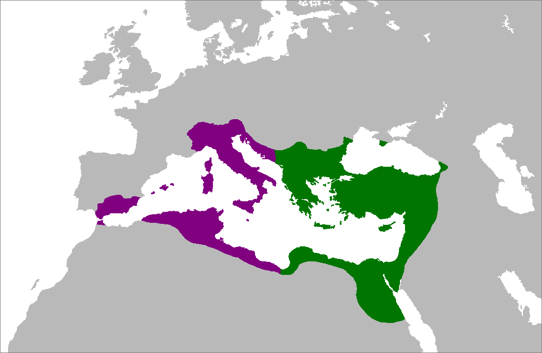
English: Map of the Byzantine Empire at its greatest extent in the 6th century. Territories in purple were reconquered during the reign of Justinian I.
العربية: خريطة الإمبراطورية البيزنطية في أقصى امتداد لها في القرن السادس. تمت السيطرة على الأراضي باللون الأرجواني في عهد جستنيان الأول. |
|||||
| 日期 | ||||||
| 来源 | 自己的作品 (原始文本: Self-made from Image:LocationRomanEmpire.png; borders based on a map from http://www.bartleby.com/.) | |||||
| 作者 | Zakuragi | |||||
| 其他版本 |
|


许可协议

|
已授权您依据自由软件基金会发行的无固定段落及封面封底文字(Invariant Sections, Front-Cover Texts, and Back-Cover Texts)的GNU自由文件许可协议1.2版或任意后续版本的条款,复制、传播和/或修改本文件。该协议的副本请见“GNU Free Documentation License”。http://www.gnu.org/copyleft/fdl.htmlGFDLGNU Free Documentation Licensetruetrue |
| 本文件采用知识共享署名-相同方式共享 3.0 未本地化版本许可协议授权。 | ||
| ||
| 本许可协议标签作为GFDL许可协议更新的组成部分被添加至本文件。http://creativecommons.org/licenses/by-sa/3.0/CC BY-SA 3.0Creative Commons Attribution-Share Alike 3.0truetrue |
说明
添加一行文字以描述该文件所表现的内容
خريطة الإمبراطورية البيزنطية في أقصى امتداد لها في القرن السادس. تم السيطرة على الأراضي باللون الأرجواني في عهد جستنيان الأول.
此文件中描述的项目
描繪內容
5 7 2007
文件历史
点击某个日期/时间查看对应时刻的文件。
| 日期/时间 | 缩略图 | 大小 | 用户 | 备注 | |
|---|---|---|---|---|---|
| 当前 | 2007年7月5日 (四) 15:28 | | 1,084 × 705(29 KB) | Tonym88~commonswiki | minor fix |
| 2007年7月4日 (三) 21:58 |  | 1,084 × 705(29 KB) | Tonym88~commonswiki | {{Information |Description= Map of the Byzantine Empire at its greatest extent in the 6th century. Territories in purple were reconquered during the reign of Justinian I. |Source= Self-made from Image:LocationRomanEmpire.png; borders based on a map f |
文件用途
没有页面链接到本图像。
全域文件用途
以下其他wiki使用此文件:
- en.wikipedia.org上的用途
- es.wikipedia.org上的用途
- hy.wikipedia.org上的用途
- ro.wikipedia.org上的用途