File:Korea_topographic_map.png
維基百科,自由的 encyclopedia
本预览的尺寸:390 × 599像素。 其他分辨率:156 × 240像素 | 312 × 480像素 | 896 × 1,376像素。
原始文件 (896 × 1,376像素,文件大小:1.18 MB,MIME类型:image/png)
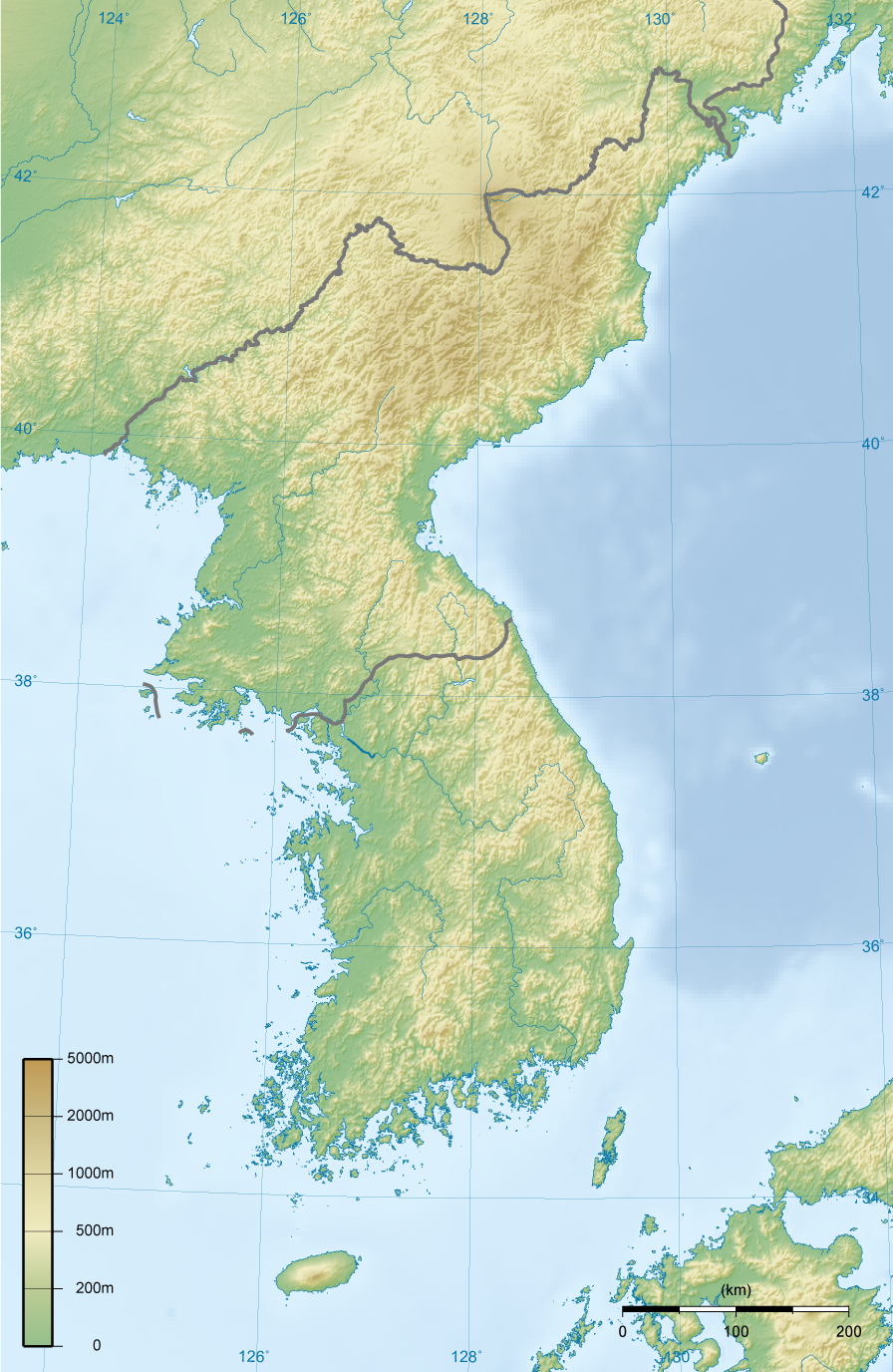
| 描述Korea topographic map.png |
English: Topographic map of Korea.
한국어: 한국의 지형도. |
||||||||||
| 日期 | |||||||||||
| 来源 | 自己的作品 | ||||||||||
| 作者 | Ksiom | ||||||||||
| 授权 (二次使用本文件) |
|
||||||||||
| 其他版本 | 此文件衍生的作品: North Korea topographic map.png |

说明
添加一行文字以描述该文件所表现的内容
此文件中描述的项目
描繪內容
9 8 2008
文件历史
点击某个日期/时间查看对应时刻的文件。
| 日期/时间 | 缩略图 | 大小 | 用户 | 备注 | |
|---|---|---|---|---|---|
| 当前 | 2009年2月27日 (五) 18:00 | | 896 × 1,376(1.18 MB) | Ksiom | Reverted to version as of 23:21, 21 February 2009. Unimpaired scale bar |
| 2009年2月22日 (日) 15:08 |  | 802 × 1,376(1.11 MB) | Valentim | Reverted to version as of 10:45, 31 January 2009. Focused view better. | |
| 2009年2月21日 (六) 23:21 |  | 896 × 1,376(1.18 MB) | Ksiom | Reverted to version as of 22:04, 13 November 2008 | |
| 2009年1月31日 (六) 10:45 |  | 802 × 1,376(1.11 MB) | Valentim | View centered on North and South Korea | |
| 2008年11月13日 (四) 22:04 |  | 896 × 1,376(1.18 MB) | Ksiom | ||
| 2008年8月16日 (六) 23:11 |  | 899 × 1,379(1.3 MB) | Ksiom | ||
| 2008年8月15日 (五) 19:33 |  | 1,039 × 1,494(1.36 MB) | Ksiom | ||
| 2008年8月15日 (五) 18:34 |  | 1,040 × 1,494(1.36 MB) | Ksiom | UTM Projection | |
| 2008年8月9日 (六) 00:52 |  | 1,000 × 1,450(1.33 MB) | Ksiom | {{Information |Description={{en|1=Topographic map of Korea.}} {{ko|1=한국의 지형도.}} |Source=Own work by uploader |Author=Ksiom |Date=2008-08-09 |Permission={{GFDL-GMT}} |other_versions= }} {{ImageUpload|full}} [[Category:Maps of Ko |
文件用途
没有页面链接到本图像。
全域文件用途
以下其他wiki使用此文件:
- ang.wikipedia.org上的用途
- br.wikipedia.org上的用途
- da.wikipedia.org上的用途
- da.wikibooks.org上的用途
- en.wikipedia.org上的用途
- fr.wikipedia.org上的用途
- fr.wiktionary.org上的用途
- mt.wikipedia.org上的用途