File:Italy_1494_AD-it.svg
維基百科,自由的 encyclopedia

此SVG文件的PNG预览的大小:443 × 599像素。 其他分辨率:177 × 240像素 | 355 × 480像素 | 568 × 768像素 | 757 × 1,024像素 | 1,515 × 2,048像素 | 688 × 930像素。
原始文件 (SVG文件,尺寸为688 × 930像素,文件大小:418 KB)
此地图或文件名的实际准确度存在争议。
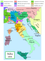
原因:This map and its derivatives need correction and update, as it is mostly based on the Shepherd's map which shows innacurate history of Venetian Republic on Eastern Adriatic, specifically of Dalmatia. It is showing seriouly erroneous and misleading Venetian control over whole region of modern Dalmatia - which became in full extent only in the late 17th and 18th century. It was never the case in the 15th and 16th century, as then most part of Dalmatian hinterland was under Hungarian-Croatian Kingdom and then Ottoman Empire. Venetian Dalmatia at the time included only the very coastal part of Dalmatia with very near hinterland of the Dalmatian city-states, the majority of the hinterland was not Venetian at all. The borders of the Ottoman conquest are also significantly erroneous for the time period as in the map look like modern borders of Bosnia and Herzegovina which became the case only many centuries later. |  |
摘要
Political map of Italy in early 1494, before the invasion of Italy by Charles VIII of France, created by MapMaster.
This is a companion map to Image:Italy 1000 AD.svg, Image:Italy 1796.png, and Image:Italy c 1810.png.
| 此SVG檔案包含可翻譯至您的語言的内嵌文字,可以使用任何可用SVG編輯器、文本編輯器或SVG翻譯工具來翻譯。詳情請見:關於翻譯SVG檔案。 |
Versions
[编辑]
PNG:
-
 阿拉伯语
阿拉伯语 -
 英语
英语 -
 希腊语
希腊语


SVG:
-
 加泰罗尼亚语
 -
 西班牙语
西班牙语 -
 法语
法语 -
 意大利语
意大利语 -
 匈牙利语
匈牙利语


See similar versions (disputed too): Map of Italy (1494)
References
- Bjorklund, Oddvar; Holmboe, Haakon; Rohr, Anders (1970) Historical Atlas of the World, Barnes & Noble, NY, SBN: 389-00253-4.
- Matthew, Donald, (1983), Atlas of Medieval Europe, Checkmark Books, New York.
- Online maps, including this 1882 map from Shepherd (the University of Texas)
- this one from A B Longman, textbook publisher.
许可协议
我,本作品著作权人,特此采用以下许可协议发表本作品:

|
已授权您依据自由软件基金会发行的无固定段落及封面封底文字(Invariant Sections, Front-Cover Texts, and Back-Cover Texts)的GNU自由文件许可协议1.2版或任意后续版本的条款,复制、传播和/或修改本文件。该协议的副本请见“GNU Free Documentation License”。http://www.gnu.org/copyleft/fdl.htmlGFDLGNU Free Documentation Licensetruetrue |
| 本文件采用知识共享署名-相同方式共享 3.0 未本地化版本许可协议授权。 | ||
| ||
| 本许可协议标签作为GFDL许可协议更新的组成部分被添加至本文件。http://creativecommons.org/licenses/by-sa/3.0/CC BY-SA 3.0Creative Commons Attribution-Share Alike 3.0truetrue |
- 您可以自由地:
- 共享 – 复制、发行并传播本作品
- 修改 – 改编作品
- 惟须遵守下列条件:
- 署名 – 您必须对作品进行署名,提供授权条款的链接,并说明是否对原始内容进行了更改。您可以用任何合理的方式来署名,但不得以任何方式表明许可人认可您或您的使用。
- 相同方式共享 – 如果您再混合、转换或者基于本作品进行创作,您必须以与原先许可协议相同或相兼容的许可协议分发您贡献的作品。
您可以选择您需要的许可协议。
derivative works
此文件衍生的作品: Italy 1494 AD-fr.svg
说明
添加一行文字以描述该文件所表现的内容
此文件中描述的项目
描繪內容
GNU自由文档许可证1.2或更高版本 简体中文(已转写)
知识共享署名-相同方式共享2.0通用 简体中文(已转写)
知识共享署名-相同方式共享2.5通用 简体中文(已转写)
知识共享署名-相同方式共享1.0通用 简体中文(已转写)
文件历史
点击某个日期/时间查看对应时刻的文件。
| 日期/时间 | 缩略图 | 大小 | 用户 | 备注 | |
|---|---|---|---|---|---|
| 当前 | 2013年6月28日 (五) 18:27 | | 688 × 930(418 KB) | Fulvio314 | Legenda, added small territories |
| 2013年5月26日 (日) 20:46 |  | 576 × 812(417 KB) | Fulvio314 | Font | |
| 2007年2月27日 (二) 15:31 |  | 567 × 812(1.17 MB) | MapMaster | Some modifications based on feedback from User:Paolo da Reggio | |
| 2007年2月23日 (五) 03:31 |  | 567 × 812(1.17 MB) | MapMaster | Italia, 1494. |
文件用途
以下页面使用本文件:
全域文件用途
以下其他wiki使用此文件:
- ar.wikipedia.org上的用途
- ast.wikipedia.org上的用途
- bg.wikipedia.org上的用途
- br.wikipedia.org上的用途
- el.wikipedia.org上的用途
- en.wikipedia.org上的用途
- eo.wikipedia.org上的用途
- eu.wikipedia.org上的用途
- fi.wikipedia.org上的用途
- fr.wikipedia.org上的用途
- hu.wikipedia.org上的用途
- it.wikipedia.org上的用途
- it.wikiquote.org上的用途
- ja.wikipedia.org上的用途
- ko.wikipedia.org上的用途
- la.wikipedia.org上的用途
- nn.wikipedia.org上的用途
- ru.wikipedia.org上的用途
- uk.wikipedia.org上的用途
- www.wikidata.org上的用途
元数据
此文件中包含有扩展的信息。这些信息可能是由数码相机或扫描仪在创建或数字化过程中所添加。
如果此文件的源文件已经被修改,一些信息在修改后的文件中将不能完全反映出来。
| 宽度 | 688.25183 |
|---|---|
| 高度 | 929.9646 |