File:Italy_1000_AD-es.svg
維基百科,自由的 encyclopedia

此SVG文件的PNG预览的大小:418 × 600像素。 其他分辨率:167 × 240像素 | 334 × 480像素 | 535 × 768像素 | 713 × 1,024像素 | 1,427 × 2,048像素 | 565 × 811像素。
原始文件 (SVG文件,尺寸为565 × 811像素,文件大小:710 KB)
摘要
| 描述Italy 1000 AD-es.svg |
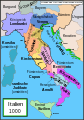
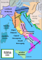
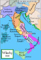
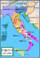
Español: Mapa de Italia hacia el año 1000. Creado por MapMaster, traducido por Molorco
English: Political map of Italy in 1000 AD (CE). Created by MapMaster, translated by Molorco
Part of a series of maps on the history of Italy:
|
| 日期 | 2008年4月10日 (原始上传日期) |
| 来源 | 无法识别来源。根据版权声明推断为其自己的作品。 |
| 作者 | 无法识别作者。根据版权声明推断作者为Molorco。 |


Other versions
[编辑]
SVG:
-
 català
 -
 čeština
 -
 Deutsch
 -
 English
 -
 español
 -
 français
 -
 Ido
Ido -
 italiano
 -
 magyar
 -
 polski
 -
 português
 -
 Türkçe
 -
 русский
 -
 українська
 -
 العربية
 -
 עברית
עברית -
 한국어
한국어 -
 中文
中文


PNG:
-
 polski
 -
 Türkçe
 -
 Ελληνικά
 -
 中文
中文


| 此SVG檔案包含可翻譯至您的語言的内嵌文字,可以使用任何可用SVG編輯器、文本編輯器或SVG翻譯工具來翻譯。詳情請見:關於翻譯SVG檔案。 |
References
- Bjorklund, Oddvar; Holmboe, Haakon; Rohr, Anders (1970) Historical Atlas of the World, Barnes & Noble, NY, SBN: 389-00253-4.
- This map from Allyn & Bacon, Longman, textbook publishers.
- This map of the w:en:Holy Roman Empire
- A map from Attilios
- This map of 1050 AD Italy, from the 1923 The Historical Atlas by William R. Shepherd
- This map of 1000 AD Italy from Fordham University, adapted from Muir's Historical Atlas, (1911).
In addition, a number of other sources were consulted in an effort to determine the following matters:
- The extent of Venetian control over the cities of Dalmatia such as Zara and Spalato. Although the Venetians had been pushed off the mainland earlier, in the period around the year 1000, the Venetians made an effort to recover these cities.
- The extent of Saracen control over Corsica and Sardinia. Information is sparse. The apparent situation is that the Muslims had several bases on the coasts of these islands, but did not control the countryside (such as they did in Sicily).
- Whether or not the principalities of Capua and Benevento were separate states in the year 1000. Based on lists of their rulers (various Pandulfs and Landulfs), the answer seems to be "yes".
- Who controlled the Balkans on the southeastern border of the Kingdom of Croatia. Candidates include Bulgaria, the Byzantine Empire, Croatia, and Serbia.
As noted, there is significant disagreement among sources on these questions.
This map was commissioned by Attilios, and there is also a discussion to be found on MapMaster's English talk page.
许可协议
我,本作品著作权人,特此采用以下许可协议发表本作品:

|
已授权您依据自由软件基金会发行的无固定段落及封面封底文字(Invariant Sections, Front-Cover Texts, and Back-Cover Texts)的GNU自由文件许可协议1.2版或任意后续版本的条款,复制、传播和/或修改本文件。该协议的副本请见“GNU Free Documentation License”。http://www.gnu.org/copyleft/fdl.htmlGFDLGNU Free Documentation Licensetruetrue |
| 本文件采用知识共享署名-相同方式共享 3.0 未本地化版本许可协议授权。 | ||
| ||
| 本许可协议标签作为GFDL许可协议更新的组成部分被添加至本文件。http://creativecommons.org/licenses/by-sa/3.0/CC BY-SA 3.0Creative Commons Attribution-Share Alike 3.0truetrue |
说明
添加一行文字以描述该文件所表现的内容
此文件中描述的项目
描繪內容
10 4 2008
image/svg+xml
文件历史
点击某个日期/时间查看对应时刻的文件。
| 日期/时间 | 缩略图 | 大小 | 用户 | 备注 | |
|---|---|---|---|---|---|
| 当前 | 2021年8月5日 (四) 19:56 | | 565 × 811(710 KB) | Rowanwindwhistler | Cleanup and fake text added |
| 2015年8月7日 (五) 09:37 |  | 565 × 811(414 KB) | Rowanwindwhistler | Ducado de Amalfi | |
| 2015年8月7日 (五) 09:33 |  | 565 × 811(414 KB) | Rowanwindwhistler | Easier to read font used, sea colour and coast colour from https://en.wikipedia.org/wiki/Wikipedia:WikiProject_Maps/Conventions | |
| 2008年10月18日 (六) 13:00 |  | 565 × 811(1.78 MB) | Durero | Borgoña nunca fue un reino | |
| 2008年4月27日 (日) 15:42 |  | 565 × 811(1.82 MB) | Molorco | {{Information |Description= |Source= |Date= |Author= |Permission= |other_versions= }} | |
| 2008年4月11日 (五) 15:12 |  | 565 × 811(1.74 MB) | Molorco | {{Information |Description= |Source= |Date= |Author= |Permission= |other_versions= }} | |
| 2008年4月10日 (四) 16:19 |  | 565 × 811(332 KB) | Molorco | {{Information |Description=Italia año 1000 }} |
文件用途
以下页面使用本文件:
全域文件用途
以下其他wiki使用此文件:
- ar.wikipedia.org上的用途
- ast.wikipedia.org上的用途
- bg.wikipedia.org上的用途
- ca.wikipedia.org上的用途
- en.wikipedia.org上的用途
- es.wikipedia.org上的用途
- Historia de Italia
- Roger I de Sicilia
- Principado de Capua
- Guaimario IV de Salerno
- Domenico Selvo
- República amalfitana
- Marca de Verona
- Ducado de Benevento
- Conquista normanda de Italia Meridional
- Principado de Salerno
- Ducado de Spoleto
- Marca de Toscana
- Anexo:Antiguos Estados de Italia
- Reino de Italia (Sacro Imperio Romano Germánico)
- Ducado de Amalfi
- Anexo:Príncipes de Capua
- Emirato de Sicilia
- Reino lombardo
- Batalla de Stilo
- Historia territorial de Italia
- Casa de Cotoner
- Kalbíes
- Historia del islam en el sur de Italia
- Familia Cesina
- gl.wikipedia.org上的用途
- io.wikipedia.org上的用途
- www.wikidata.org上的用途
元数据
此文件中包含有扩展的信息。这些信息可能是由数码相机或扫描仪在创建或数字化过程中所添加。
如果此文件的源文件已经被修改,一些信息在修改后的文件中将不能完全反映出来。
| 宽度 | 565.08997 |
|---|---|
| 高度 | 811.03571 |