File:Hong_Kong_Skyline_Restitch_-_Dec_2007.jpg
維基百科,自由的 encyclopedia
原始文件 (4,250 × 1,844像素,文件大小:3.93 MB,MIME类型:image/jpeg)
摘要
| 描述Hong Kong Skyline Restitch - Dec 2007.jpg |
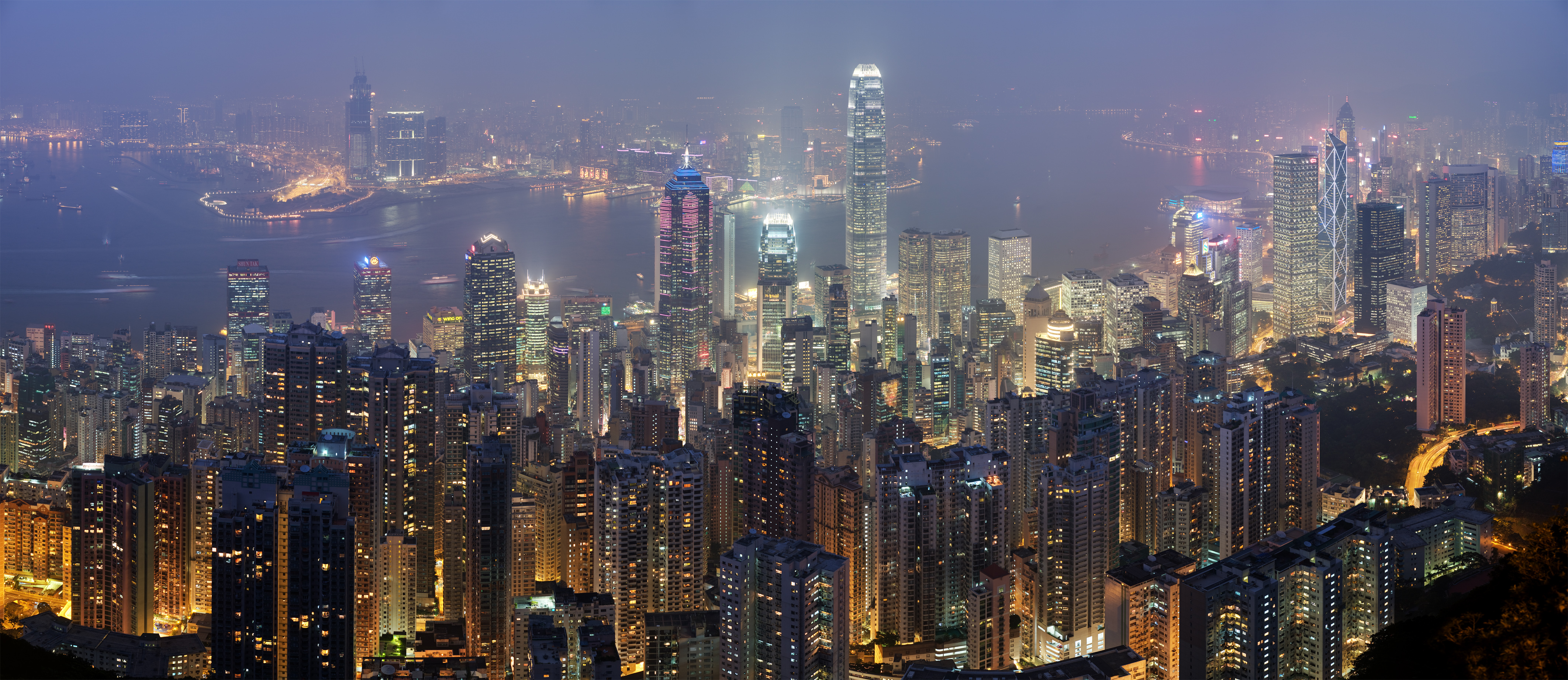
Deutsch: Skyline von Hong Kong betrachtet vom Victoria Peak. Zusammengesetzt aus 78 Aufnahmen (26×3).
English: A 26 segment × 3 exposure (78 frames in total) panoramic view of the Hong Kong skyline taken from a path around Victoria Peak.
Français : Vue panoramique de Hong Kong depuis un sentier de Victoria Peak. Image construite en assemblant 78 clichés (26 visées × 3 expositions) réalisés avecun appareil Canon 5D et un objectif 85mm f/1.8 réglé sur f/5.6. |
| 日期 | |
| 来源 | 自己的作品 |
| 作者 | Diliff |
| 授权 (二次使用本文件) |
Summary:In using this image or any subsequent derivatives of it, you are required to release the image under the same license. As such, any reproduction of this image, in any medium, must appear with a copy of, or full URL of the license.Attribution of this image to the author (DAVID ILIFF) is also required, preferably in a prominent location near the image.No other conditions may be added to, or removed from this license without the permission of the author and copyright holder.Suggested attribution: "Photo by DAVID ILIFF. License: CC BY-SA 3.0"Please review the full license requirements carefully before using this image. If you would like to clarify the terms of the license or negotiate less restrictive commercial licensing outside of the bounds of GFDL/CC-BY-SA, please contact me by email, or if you don't have a Wikipedia account you can either leave a message on my talk page with your contact details and your request, or you can contact me on Facebook. Please also send a 'friend request' to ensure that I am aware of your message. |
| 其他版本 |
|

| 相机位置 | 22° 16′ 41.36″ 北, 114° 08′ 48.68″ 东 | 在以下服务上查看本图像和附近其他图像: OpenStreetMap |
|---|
|
English: Panoramic view of the Hong Kong skyline taken from a path around Victoria Peak 其他语言:
Bosanski: Panoramski pogled na hongkoški horizont sa staze kod vrha Viktorija. English: Panoramic view of the Hong Kong skyline taken from a path around Victoria Peak Español: Vista panorámica del distrito central de Hong Kong desde la Cumbre Victoria. Français : Vue panoramique de Hong Kong depuis un sentier de Victoria Peak. Image construite en assemblant 78 clichés (26 visées × 3 expositions) réalisés avec un appareil Canon 5D et un objectif 85mm f/1.8 réglé sur f/5.6. Italiano: Vista di Hong Kong dal Victoria Peak, Cina. Magyar: Hongkongi panorámakép a Viktória-csúcsról nézve Nederlands: Panorama van het stedelijk silhouet van Hongkong, gezien vanaf een pad rond Victoria Peak, de hoogste berg van Hongkong Island Português: Vista panorâmica do distrito central de Hong Kong, feita dos arredores do pico Victoria. Suomi: Näkymä Hong Kongin yli läheiseltä Victoria Peak -vuorelta Беларуская: Панарама Ганконга з гары Вікторыя-Пік. Українська: Панорама Гонконгу з гори Вікторія (Victoria Peak) मराठी: हाँग काँग चे परिदृश्य 한국어: 홍콩 빅토리아 피크에서 바라본 야경. العربية : صورة بانورامية للأفق في هونج كونج. |
| 照相机型号 | Canon EOS 5D |
|---|---|
| 光圈 | f/5.6 |
| 鏡頭 | 85 mm f/1.8 |
|
العربية ∙ جازايرية ∙ беларуская ∙ беларуская (тарашкевіца) ∙ български ∙ বাংলা ∙ català ∙ čeština ∙ Cymraeg ∙ Deutsch ∙ Schweizer Hochdeutsch ∙ Zazaki ∙ Ελληνικά ∙ English ∙ Esperanto ∙ español ∙ eesti ∙ euskara ∙ فارسی ∙ suomi ∙ français ∙ galego ∙ עברית ∙ हिन्दी ∙ hrvatski ∙ magyar ∙ հայերեն ∙ Bahasa Indonesia ∙ italiano ∙ 日本語 ∙ Jawa ∙ ქართული ∙ 한국어 ∙ kurdî ∙ Lëtzebuergesch ∙ lietuvių ∙ македонски ∙ മലയാളം ∙ मराठी ∙ Bahasa Melayu ∙ Nederlands ∙ Norfuk / Pitkern ∙ polski ∙ português ∙ português do Brasil ∙ rumantsch ∙ română ∙ русский ∙ sicilianu ∙ slovenčina ∙ slovenščina ∙ shqip ∙ српски / srpski ∙ svenska ∙ தமிழ் ∙ తెలుగు ∙ ไทย ∙ Tagalog ∙ Türkçe ∙ toki pona ∙ українська ∙ vèneto ∙ Tiếng Việt ∙ 中文 ∙ 中文(简体) ∙ 中文(繁體) ∙ +/− |
许可协议

|
已授权您依据自由软件基金会发行的无固定段落及封面封底文字(Invariant Sections, Front-Cover Texts, and Back-Cover Texts)的GNU自由文件许可协议1.2版或任意后续版本的条款,复制、传播和/或修改本文件。该协议的副本请见“GNU Free Documentation License”。http://www.gnu.org/copyleft/fdl.htmlGFDLGNU Free Documentation Licensetruetrue |
- 您可以自由地:
- 共享 – 复制、发行并传播本作品
- 修改 – 改编作品
- 惟须遵守下列条件:
- 署名 – 您必须对作品进行署名,提供授权条款的链接,并说明是否对原始内容进行了更改。您可以用任何合理的方式来署名,但不得以任何方式表明许可人认可您或您的使用。
说明
此文件中描述的项目
描繪內容
GNU自由文档许可证1.2或更高版本 简体中文(已转写)
13 12 2007
共享资源质量评价 简体中文(已转写)
22°16'41.362386686407"N, 114°8'48.677558898926"E
image/jpeg
文件历史
点击某个日期/时间查看对应时刻的文件。
| 日期/时间 | 缩略图 | 大小 | 用户 | 备注 | |
|---|---|---|---|---|---|
| 当前 | 2008年4月29日 (二) 21:55 | | 4,250 × 1,844(3.93 MB) | Diliff | == Summary == {{Information |Description={{en|A 26 segment x 3 exposure (78 frames in total) panoramic view of the Hong Kong skyline taken from a path around Victoria Peak. Taken by myself with a Canon 5D and 85mm f/1.8 lens at f/5.6.}} {{de|Skyline von H |
文件用途
以下64个页面使用本文件:
- Talk:擁有最多摩天大樓的城市列表
- User:*angys*/个人信息
- User:Amy 98se
- User:Andywu476/用戶框
- User:AvriLeslie
- User:Beurre de champignons
- User:Dksh1412
- User:Dr.Vu
- User:Edmonomer
- User:Edmonomer/用戶主頁
- User:Hanjack
- User:HenryMakerCH
- User:HugoKoo
- User:Huleizhulei
- User:ItsLiana
- User:Jack Zhaodong
- User:Kagayuta
- User:Ljhanson
- User:Lodi Leung/用戶框
- User:Marcus16011
- User:Piggy Studio/用戶框
- User:Pillow lin
- User:Ponytailor
- User:Prydain Fawr
- User:QuYi96
- User:Recollections
- User:Rethliopuks/用戶框
- User:SalmonGenZ
- User:Selums
- User:Sin-siōng
- User:Skiate
- User:SteveLLL
- User:StevenK234
- User:StevenK234/MainPage/Userbox
- User:Subscriptshoe9/用戶頁/存檔/1
- User:Takahitooh
- User:Teshiohoshimi
- User:Trustwk/userbox
- User:WMwiki
- User:WenChuanHighway
- User:Win of Switzerland
- User:XunZiReturn
- User:Zhuerba1
- User:哈哈哈哈哈哈呵呵呵呵呵呵
- User:喜歡多元討論的天龍人
- User:天言
- User:御坂雪奈
- User:暁月凛奈
- User:暁月凛奈/UBX
- User:杜春綺
- User:章戍衡
- User:肆意醉飲思緒清/我的用戶框
- User:鐵路1/用戶框
- User:鬼人正邪
- User:麦丝鱿鱼
- Wikipedia:每日图片/2008年7月
- Wikipedia:每日图片/2008年7月6日
- Wikipedia:用戶框/文化
- Wikipedia:用戶框/興趣
- Template:User Modern architecture
- Portal:中国/挑选出来的图片/2
- Portal:中国/挑选出来的文章和图片
- Portal:中国/特色图片/2
- Portal:中国/特色图片/存档
全域文件用途
以下其他wiki使用此文件:
- ace.wikipedia.org上的用途
- af.wikipedia.org上的用途
- arc.wikipedia.org上的用途
- ar.wikipedia.org上的用途
- arz.wikipedia.org上的用途
- as.wikipedia.org上的用途
- azb.wikipedia.org上的用途
- bn.wikipedia.org上的用途
- bxr.wikipedia.org上的用途
- ca.wikipedia.org上的用途
- ceb.wikipedia.org上的用途
- crh.wikipedia.org上的用途
- cs.wikipedia.org上的用途
- cv.wikipedia.org上的用途
- da.wikipedia.org上的用途
- de.wikipedia.org上的用途
- diq.wikipedia.org上的用途
- dv.wikipedia.org上的用途
- el.wikipedia.org上的用途
- en.wikipedia.org上的用途
- User:Diliff
- Portal:Politics/Featured content
- Wikipedia:WikiProject Urban studies and planning
- Portal:China/Selected article and pictures
- Wikipedia:WikiProject Countries/Assessment
- Portal:Capitalism/Selected article
- Portal:Capitalism/Selected article/1
- Wikipedia:Featured pictures/Places/Panorama
- Wikipedia:WikiProject China/Featured and good content
- Portal:China/Selected picture
- Portal:Architecture/Townscape images
查看此文件的更多全域用途。
元数据
此文件中包含有扩展的信息。这些信息可能是由数码相机或扫描仪在创建或数字化过程中所添加。
如果此文件的源文件已经被修改,一些信息在修改后的文件中将不能完全反映出来。
| 宽度 | 8,663 px |
|---|---|
| 高度 | 6,966 px |
| 压缩方案 | PackBits(Macintosh RLE) |
| 像素构成 | RGB |
| 方向 | 正常 |
| 色彩组分数 | 4 |
| 水平分辨率 | 300 dpi |
| 垂直分辨率 | 300 dpi |
| 数据排布 | 大块格式 |
| 使用软件 | Adobe Photoshop CS3 Windows |
| 文件修改日期时间 | 2008年4月29日 (二) 22:50 |
| 色彩空间 | 未标定 |
| 图像宽度 | 4,250 px |
| 图像高度 | 1,844 px |
| 每色彩组分位数 |
|
| 数字化日期时间 | 2008年4月29日 (二) 23:50 |
| 元数据最后修改日期 | 2008年4月29日 (二) 23:50 |