File:Basse_Mesopotamie_PB.PNG
維基百科,自由的 encyclopedia
此为最大尺寸。
Basse_Mesopotamie_PB.PNG (440 × 393像素,文件大小:157 KB,MIME类型:image/png)
| 描述Basse Mesopotamie PB.PNG |
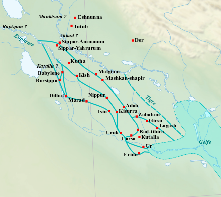
English: Location map of the main cities of Lower Mesopotamia during the Old Babylonian period (2004-1595 BC). With the approximate course of the rivers and the ancient shoreline of the Gulf. Français : Carte de localisation des principales villes de la Basse Mésopotamie durant la période paléo-babylonienne (2004-1595 av. J.-C.). Avec le tracé approximatif des fleuves et l'ancien trait de côte du Golfe. |
| 日期 | (UTC) |
| 来源 | |
| 作者 |
|
| 这是一张修改过的图片,这意味着它已在原版本的基础上通过软件进行了编辑,改动内容:Ajout des villes, du tracé des fleuves antiques et du trait de côte du Golfe.。其原始版本为:Near East topographic map-blank.svg。修改者:Zunkir。
|
我,本作品著作权人,特此采用以下许可协议发表本作品:
- 您可以自由地:
- 共享 – 复制、发行并传播本作品
- 修改 – 改编作品
- 惟须遵守下列条件:
- 署名 – 您必须对作品进行署名,提供授权条款的链接,并说明是否对原始内容进行了更改。您可以用任何合理的方式来署名,但不得以任何方式表明许可人认可您或您的使用。
- 相同方式共享 – 如果您再混合、转换或者基于本作品进行创作,您必须以与原先许可协议相同或相兼容的许可协议分发您贡献的作品。

|
已授权您依据自由软件基金会发行的无固定段落及封面封底文字(Invariant Sections, Front-Cover Texts, and Back-Cover Texts)的GNU自由文件许可协议1.2版或任意后续版本的条款,复制、传播和/或修改本文件。该协议的副本请见“GNU Free Documentation License”。http://www.gnu.org/copyleft/fdl.htmlGFDLGNU Free Documentation Licensetruetrue |
您可以选择您需要的许可协议。
原始上传日志
This image is a derivative work of the following images:
- File:Near_East_topographic_map-blank.svg licensed with Cc-by-sa-3.0,2.5,2.0,1.0, GFDL
- 2009-08-18T18:31:37Z Sémhur 2425x1581 (2442670 Bytes) 3 - New try
- 2009-08-17T15:39:22Z Sémhur 2425x1581 (1815374 Bytes) 2 - With the background...
- 2009-08-17T15:37:36Z Sémhur 2425x1581 (2836 Bytes) {{Information |Description={{en|1=Blank physical map of the [[:en:Near East|Near East]]}} {{fr|1=Carte physique vierge du [[:fr:Proche-Orient|Proche-Orient]].}} |Source={{own}} |Author=[[User:Sémhur|Sémhur]] |Date=2008-08-1
Uploaded with derivativeFX
说明
添加一行文字以描述该文件所表现的内容
此文件中描述的项目
描繪內容
知识共享署名-相同方式共享2.0通用 简体中文(已转写)
知识共享署名-相同方式共享2.5通用 简体中文(已转写)
知识共享署名-相同方式共享1.0通用 简体中文(已转写)
GNU自由文档许可证1.2或更高版本 简体中文(已转写)
image/png
160,646 字节
393 像素
440 像素
文件历史
点击某个日期/时间查看对应时刻的文件。
| 日期/时间 | 缩略图 | 大小 | 用户 | 备注 | |
|---|---|---|---|---|---|
| 当前 | 2023年2月26日 (日) 10:21 | | 440 × 393(157 KB) | Zunkir | opacité, cours d'eau, villes |
| 2017年12月10日 (日) 21:02 |  | 1,026 × 736(588 KB) | Bulldoc | aggiunta Umma ed il terreno della Guedemma, causa della guerra con Lagash | |
| 2017年1月13日 (五) 01:17 |  | 1,026 × 736(814 KB) | Kindattu2004 | Cities of Kisurra and Kutalla added | |
| 2010年9月28日 (二) 16:59 |  | 1,026 × 736(826 KB) | Zunkir | {{Information |Description={{en|1=Location map of the main cities of Lower Mesopotamia during the paleo-babylonian period (2004-1595 BC). With the approximate course of the rivers and the ancient shoreline of the Gulf.}} {{fr|1=Carte de localisation des p |
文件用途
没有页面链接到本图像。
全域文件用途
以下其他wiki使用此文件:
- ar.wikipedia.org上的用途
- arz.wikipedia.org上的用途
- ca.wikipedia.org上的用途
- ceb.wikipedia.org上的用途
- en.wikipedia.org上的用途
- es.wikipedia.org上的用途
- fi.wikibooks.org上的用途
- fr.wikipedia.org上的用途
- it.wikipedia.org上的用途
- pl.wikipedia.org上的用途
查看此文件的更多全域用途。