File:1771_Bonne_Map_of_Tonkin_(Vietnam)_China,_Formosa_(Taiwan)_and_Luzon_(Philippines)_-_Geographicus_-_Formosa-bonne-1771.jpg
維基百科,自由的 encyclopedia
本预览的尺寸:800 × 583像素。 其他分辨率:320 × 233像素 | 640 × 466像素 | 1,024 × 746像素 | 1,280 × 933像素 | 2,560 × 1,866像素 | 4,000 × 2,915像素。
原始文件 (4,000 × 2,915像素,文件大小:3.17 MB,MIME类型:image/jpeg)
| Rigobert Bonne:Carte Hydro-Geo-Graphique des Indes Orientales en deca et au dela du Gange avec leur Archipel Dressee et assujettie aux Observations Astronomiques.
( |
|||||||||||||||||||||||
|---|---|---|---|---|---|---|---|---|---|---|---|---|---|---|---|---|---|---|---|---|---|---|---|
| 艺术家 |
artist QS:P170,Q721492 |
||||||||||||||||||||||
| 标题 |
Carte Hydro-Geo-Graphique des Indes Orientales en deca et au dela du Gange avec leur Archipel Dressee et assujettie aux Observations Astronomiques. |
||||||||||||||||||||||
| 描述 |
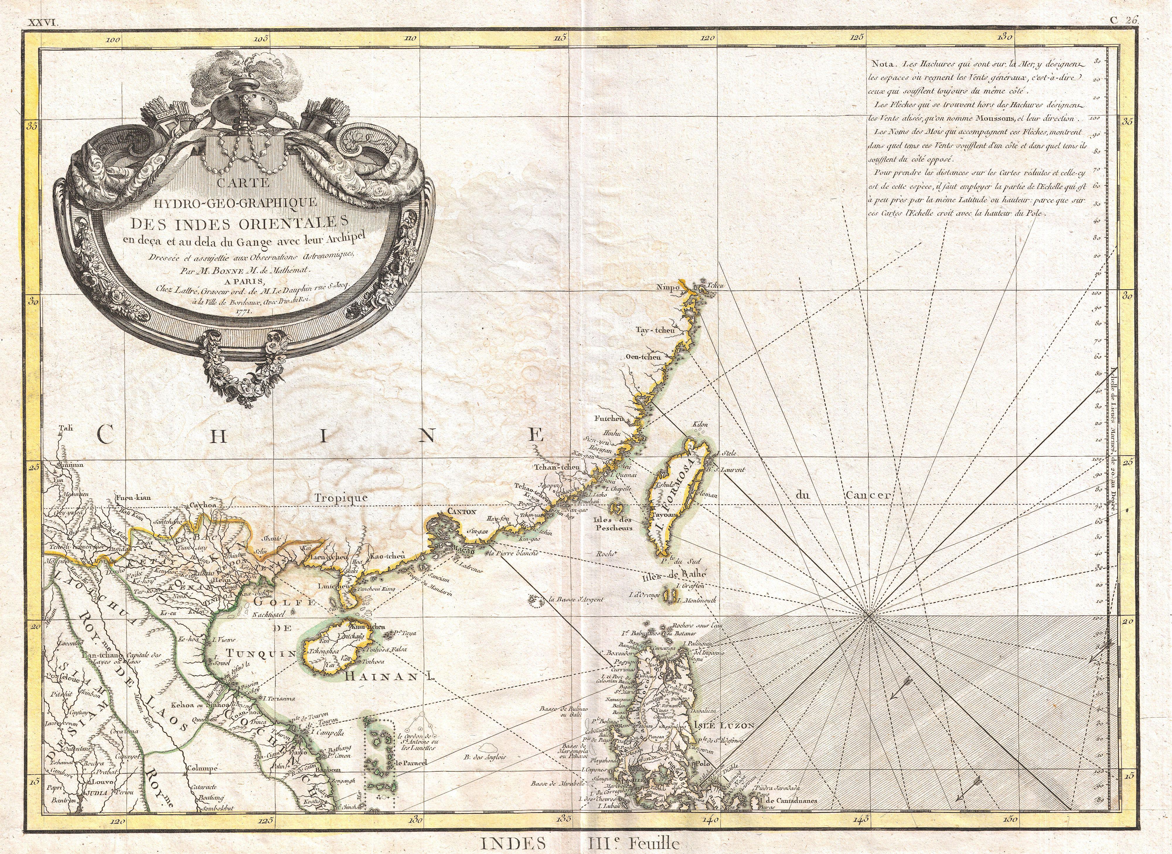
English: A beautiful example of Rigobert Bonne's 1771 uncommon map of southeastern China. Covers from the Kingdom of Siam (Thailand) to include Laos, Tonkin (northern Vietnam), Cochin Chi (southern Vietnam), the island of Hainan, Formosa (Taiwan) and the Island of Luzon (northern Philippines). Notes Macao and Canton and shows, but does not label, Hong Kong Island. Tayoan is noted on Formosa. Offers little inland detail with regard to China itself. Notes in the upper right hand corner comment on the Monsoons. Rhumb lines throughout. Arrows in the lower right show the direction of the prevailing winds. A fine map of the region. Drawn by R. Bonne in 1771 for issue as plate no. C 26 in Jean Lattre's 1776 issue of the Atlas Moderne . |
||||||||||||||||||||||
| 日期 | 1771年 (dated) | ||||||||||||||||||||||
| 尺寸 |
高度:12英寸(30.4厘米);宽度:16.5英寸(41.9厘米) dimensions QS:P2048,12U218593 dimensions QS:P2049,16.5U218593 |
||||||||||||||||||||||
| 登录号 |
Geographicus link: Formosa-bonne-1771 |
||||||||||||||||||||||
| 来源/摄影师 |
Lattre, Jean, Atlas Moderne ou Collection de Cartes sur Toutes les Parties du Globe Terrestre, c. 1775.
|
||||||||||||||||||||||
| 授权 (二次使用本文件) |
|
||||||||||||||||||||||
| 其他版本 |
|
||||||||||||||||||||||
.jpg)
_map_by_Bonne.jpg)
说明
添加一行文字以描述该文件所表现的内容
此文件中描述的项目
描繪內容
image/jpeg
3,326,036 字节
2,915 像素
4,000 像素
文件历史
点击某个日期/时间查看对应时刻的文件。
| 日期/时间 | 缩略图 | 大小 | 用户 | 备注 | |
|---|---|---|---|---|---|
| 当前 | 2011年3月23日 (三) 02:47 | | 4,000 × 2,915(3.17 MB) | BotMultichillT | {{subst:User:Multichill/Geographicus |link=http://www.geographicus.com/P/AntiqueMap/Formosa-bonne-1771 |product_name=1771 Bonne Map of Tonkin (Vietnam) China, Formosa (Taiwan) and Luzon (Philippines) |map_title=Carte Hydro-Geo-Graphique des Indes Oriental |
文件用途
以下页面使用本文件:
全域文件用途
以下其他wiki使用此文件:
- en.wikipedia.org上的用途
- id.wikipedia.org上的用途
- www.wikidata.org上的用途
_China,_Formosa_(Taiwan)_and_Luzon_(Philippines)_-_Geographicus_-_Formosa-bonne-1771.jpg)