File:World_in_820.png
From Wikipedia, the free encyclopedia
預覽大細:800 × 400 像素。 第啲解像度:320 × 160 像素|640 × 320 像素。
原本檔案 (1,200 × 600 像素,檔案大細:42 KB ,MIME類型:image/png)
摘要
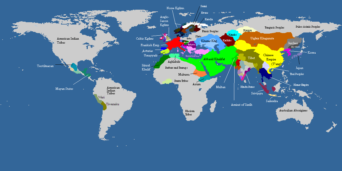
| 描述World in 820.png |
Deutsch: Weltkarte, ca. um 820 n.Chr. Farbige Gebiete zeigen den Einfluss von grösseren Mächten in dieser Zeit, die Kontrolle über manche dieser Gebiete sind z.T. nur nominell vorhanden. Graue Gebiete waren entweder vorwiegend von Ureinwohnern besiedelt oder unbewohnt.
English: Map of the world, c. AD 820. Colored areas show the extent of influence for the major empires of the period; control over some areas may have been purely nominal. Gray areas showed areas that are mainly inhabited by Indigineous populations, or completely uninhabited.
한국어: 서기 820년의 세계지도입니다. 색깔이 있는 지역은 이 시대의 현존했던 왕국과 제국의 영향력을 보여주는 것입니다. 회색지역은 인디언이나 국가가 없던 지역이거나 혹은 사람이 살지 않은 곳입니다. |
||
| 日期 | not stated | ||
| 來源 | from academic sources | ||
| 作者 | multiple authors | ||
| Other versions |
|

| Maps of world history | |
| BC | |
|
| |
| AD |
1 · 50 · 100 · 200 · 250 · 300 · 400 · 500 · 700 · 750 · 820 · 900 · 1200 · 1500 · 1556 · 1648 · 1700 · 1750 · 1815 · 1859 · 1871 · 1914 · 1935 · 1954 · 1989 · 2000 · |
|
Maps of colonization history | |
|
see also: Eastern Hemisphere only maps template (1300BC-1500AD) | |
| (this template: · view · discuss ) | |
.jpg)
._LOC_2001620596.jpg)

|
This historical map image could be recreated using vector graphics as an SVG file. This has several advantages; see Commons:Media for cleanup for more information. If an SVG form of this image is already available, please upload it. After uploading an SVG, replace this template with {{vector version available|new image name.svg}}.
|
協議
| 呢個檔案用共享創意 姓名標示-非商業性-相同方式分享3.0 未本地化版本條款授權。 Subject to disclaimers. | ||
| ||
| This licensing tag was added to this file as part of the GFDL licensing update.http://creativecommons.org/licenses/by-sa/3.0/CC BY-SA 3.0Creative Commons Attribution-Share Alike 3.0truetrue |

|
根據自由軟體基金會發佈嘅無固定段落、封面文字同封底文字GNU自由文件授權條款第1.2或打後嘅版本,你獲授權可以重製、散佈同埋修改爾份文件。授權條款嘅副本喺章節GNU自由文件授權條款。 Subject to disclaimers.http://www.gnu.org/copyleft/fdl.htmlGFDLGNU Free Documentation Licensetruetrue |
Captions
Add a one-line explanation of what this file represents
Items portrayed in this file
圖中顯示嘅係
檔案歷史
撳個日期/時間去睇響嗰個時間出現過嘅檔案。
| 日期/時間 | 縮圖 | 尺寸 | 用戶 | 註解 | |
|---|---|---|---|---|---|
| 現時 | 2022年11月20號 (日) 10:06 | | 1,200 × 600(42 KB) | Roy17 | Reverted to version as of 15:56, 11 May 2009 (UTC) Commons:Overwriting existing files ✘ Major changes (e.g. a radical crop) |
| 2019年11月16號 (六) 12:52 |  | 4,974 × 2,519(629 KB) | Anchuhu | [[Media:]] | |
| 2016年8月10號 (三) 12:44 |  | 646 × 408(27 KB) | Garam | Reverted to version as of 13:11, 11 July 2012 (UTC) | |
| 2013年12月14號 (六) 14:28 |  | 1,170 × 486(40 KB) | Billinghurst | Reverted to version as of 00:40, 7 June 2009, prior to expansion to other areas | |
| 2012年7月11號 (三) 13:11 |  | 646 × 408(27 KB) | Runehelmet | updated | |
| 2011年4月11號 (一) 08:30 |  | 644 × 408(15 KB) | Garam | Fix. (The northern area of Taedong River is Balhae territory. Now version border is Goryeo territory.) | |
| 2011年4月10號 (日) 09:21 |  | 644 × 408(15 KB) | Garam | Fix the name (Goryeo - A.D. 918 ~ A.D. 1392, Silla - B.C. 57 ~ A.D. 935, Later Three Kingdoms - A.D. 892 ~ A.D. 936) | |
| 2010年3月19號 (五) 17:19 |  | 644 × 408(10 KB) | Aiyizo | compressed with pngout | |
| 2010年1月17號 (日) 19:29 |  | 644 × 408(30 KB) | Ecthelion83 | Reverted to version as of 19:28, 17 January 2010 | |
| 2010年1月17號 (日) 19:29 |  | 644 × 408(30 KB) | Ecthelion83 | Reverted to version as of 19:27, 17 January 2010 |
檔案用途
無嘢連來呢份檔案。
全域檔案使用情況
下面嘅維基都用緊呢個檔案:
- en.wikipedia.org嘅使用情況
- es.wikipedia.org嘅使用情況