File:Mapa_Geografico_de_America_Meridional_(1790).jpg
From Wikipedia, the free encyclopedia
預覽大細:424 × 599 像素。 第啲解像度:170 × 240 像素|339 × 480 像素|543 × 768 像素|1,059 × 1,497 像素。
原本檔案 (1,059 × 1,497 像素,檔案大細:558 KB ,MIME類型:image/jpeg)
摘要
| 描述Mapa Geografico de America Meridional (1790).jpg |
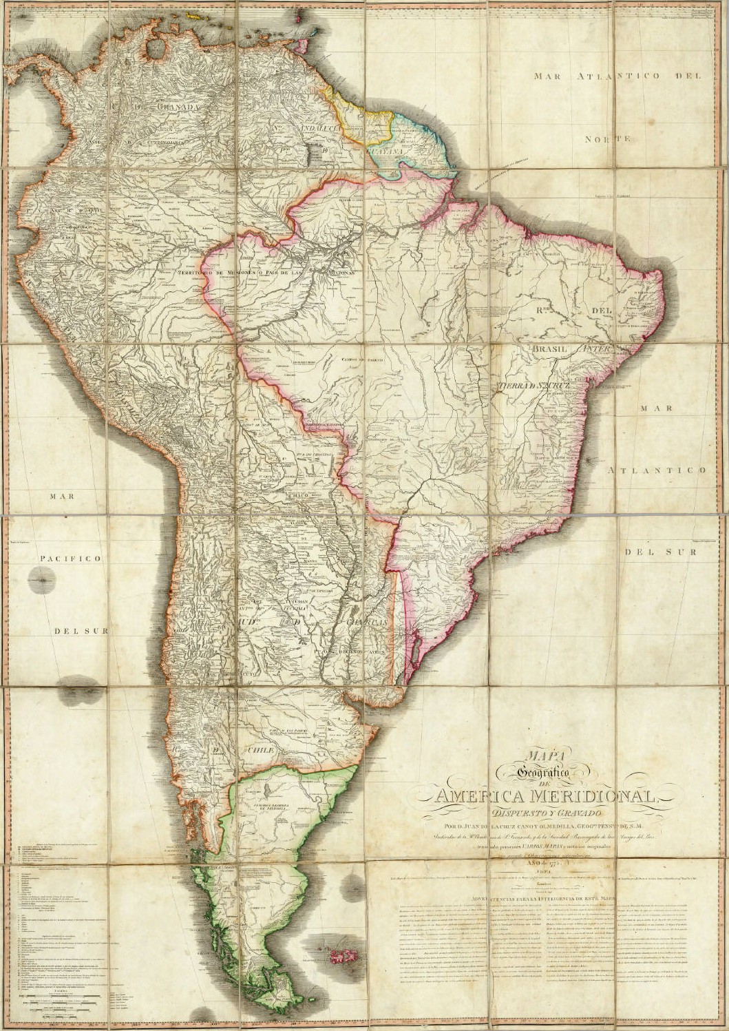
English: Geographical Map of South America, Drawn and Engraved by Mr. Juan de la Cruz Cano y Olmedilla, Geographer to His Majesty...
Español: Mapa Geografico de America Meridional, dispuesto y gravado por D. Juan de la Cruz Cano y Olmedilla, Geogfo. Pensdo. de S. M. Individuo de la R. Academia de Sn. Fernando, y da la Sociedad Bascongada de los Amigos del Pais, teniendo presentes Varios Mapas y noticias originales con arreglo a Observaciones astronómicas (Año 1775.) Londres, Publicado por William Faden, Geografo del Rey, y del Principe de Gales, Enero 1 de 1799. |
||||||||||||||||||||||
| 日期 | 1775, reprinted 1799 | ||||||||||||||||||||||
| 來源 | Unknown sourceUnknown source | ||||||||||||||||||||||
| 作者 |
creator QS:P170,Q8008902 |
||||||||||||||||||||||
| Other versions |
|
||||||||||||||||||||||
.jpg)
協議
|
This is a faithful photographic reproduction of a two-dimensional, public domain work of art. The work of art itself is in the public domain for the following reason:
The official position taken by the Wikimedia Foundation is that "faithful reproductions of two-dimensional public domain works of art are public domain".
This photographic reproduction is therefore also considered to be in the public domain in the United States. In other jurisdictions, re-use of this content may be restricted; see Reuse of PD-Art photographs for details. | |||||
Captions
Add a one-line explanation of what this file represents
Items portrayed in this file
圖中顯示嘅係
1790
檔案歷史
撳個日期/時間去睇響嗰個時間出現過嘅檔案。
| 日期/時間 | 縮圖 | 尺寸 | 用戶 | 註解 | |
|---|---|---|---|---|---|
| 現時 | 2006年5月14號 (日) 02:37 | | 1,059 × 1,497(558 KB) | Fbaltra | |
| 2006年5月14號 (日) 02:32 |  | 1,097 × 1,536(360 KB) | Fbaltra | == Summary == Mapa Geografico de America Meridional de Juan de la Cruz Cano y Olmedilla, 1790. Publicado en 1799 por William Faden, Londres. == Licensing == {{PD-Art}} Category:Historical maps of South America Category:Historical maps of Chile |
檔案用途
無嘢連來呢份檔案。
全域檔案使用情況
下面嘅維基都用緊呢個檔案:
- de.wikipedia.org嘅使用情況
- en.wikipedia.org嘅使用情況
- es.wikipedia.org嘅使用情況
- it.wikipedia.org嘅使用情況
- roa-tara.wikipedia.org嘅使用情況
Metadata
呢個檔案有額外嘅資料。佢應該係數碼相機或者掃描器整出來嘅。如果佢整咗之後畀人改過,裏面嘅資料未必同改過之後相符。
| _error | 0 |
|---|
.jpg)