File:Stockport_bus_station_-_geograph.org.uk_-_1413991_cropped.jpg
From Wikipedia, the free encyclopedia
預覽大細:800 × 456 像素。 第啲解像度:320 × 182 像素|640 × 365 像素|930 × 530 像素。
原本檔案 (930 × 530 像素,檔案大細:310 KB ,MIME類型:image/jpeg)
| 描述Stockport bus station - geograph.org.uk - 1413991 cropped.jpg |
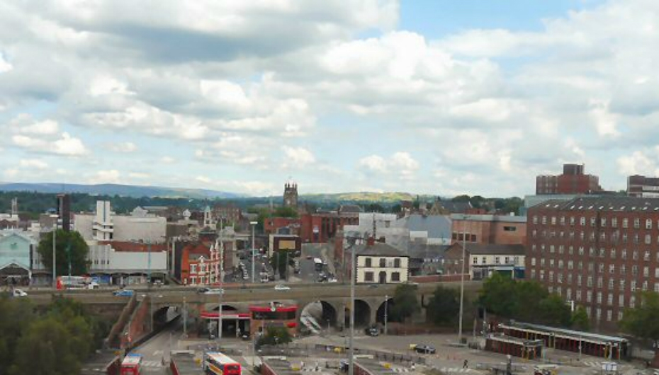
English: Stockport bus station, Stockport, Greater Manchester, England as viewed from the viaduct. Another view. In mid-distance is St Mary's church and to the right is the Hat Museum. |
| 日期 | |
| 來源 |
This file was derived from: Stockport bus station - geograph.org.uk - 1413991.jpg |
| 作者 |
|
| 姓名標示 (required by the license) InfoField | Gerald England / Stockport bus station / |
InfoField | Gerald England / Stockport bus station |
| Camera location | 53° 24′ 32.55″ N, 2° 09′ 49.6″ W | View this and other nearby images on: OpenStreetMap |
|---|
| This is a retouched picture, which means that it has been digitally altered from its original version. Modifications: cropped. The original can be viewed here: Stockport bus station - geograph.org.uk - 1413991.jpg:
|
This file is licensed under the Creative Commons Attribution-Share Alike 2.0 Generic license.
姓名標示: Gerald England
- 你可以:
- 去分享 – 複製、發佈同傳播呢個作品
- 再改 – 創作演繹作品
- 要遵照下面嘅條件:
- 署名 – 你一定要畀合適嘅表彰、畀返指向呢個授權條款嘅連結,同埋寫明有無改過嚟。你可以用任何合理方式去做,但唔可以用任何方式暗示授權人認可咗你或者你嘅使用方式。
- 相同方式分享 – 如果你用任何方式改過呢個作品,你必須要用返原本或者相似嘅條款發佈。
Original upload log
This image is a derivative work of the following images:
- File:Stockport_bus_station_-_geograph.org.uk_-_1413991.jpg licensed with Cc-by-sa-2.0, Geograph
Uploaded with derivativeFX
Captions
Add a one-line explanation of what this file represents
Items portrayed in this file
圖中顯示嘅係
53°24'32.548"N, 2°9'49.604"W
25 7 2009
檔案歷史
撳個日期/時間去睇響嗰個時間出現過嘅檔案。
| 日期/時間 | 縮圖 | 尺寸 | 用戶 | 註解 | |
|---|---|---|---|---|---|
| 現時 | 2015年6月17號 (三) 17:21 | | 930 × 530(310 KB) | Joe Vitale 5 | better image |
| 2011年6月19號 (日) 21:40 |  | 640 × 320(112 KB) | BaldBoris | {{Information |Description={{en|1=Stockport bus station The bus station 1135589 at Stockport as viewed from the viaduct. In mid-distance is St Mary's church 1405627 and to the right is the Hat Museum 1349948.}} |date=2009-07-25 |Source=*[[:Fil |
檔案用途
以下嘅1版用到呢個檔:
全域檔案使用情況
下面嘅維基都用緊呢個檔案:
- an.wikipedia.org嘅使用情況
- ar.wikipedia.org嘅使用情況
- arz.wikipedia.org嘅使用情況
- ast.wikipedia.org嘅使用情況
- azb.wikipedia.org嘅使用情況
- az.wikipedia.org嘅使用情況
- be.wikipedia.org嘅使用情況
- cs.wikipedia.org嘅使用情況
- cy.wikipedia.org嘅使用情況
- da.wikipedia.org嘅使用情況
- de.wikivoyage.org嘅使用情況
- en.wikivoyage.org嘅使用情況
- eo.wikipedia.org嘅使用情況
- eu.wikipedia.org嘅使用情況
- fr.wikipedia.org嘅使用情況
- ga.wikipedia.org嘅使用情況
- he.wikipedia.org嘅使用情況
- hy.wikipedia.org嘅使用情況
- it.wikipedia.org嘅使用情況
- it.wikivoyage.org嘅使用情況
- ka.wikipedia.org嘅使用情況
- ko.wikipedia.org嘅使用情況
- lld.wikipedia.org嘅使用情況
- nl.wikipedia.org嘅使用情況
- nn.wikipedia.org嘅使用情況
- pt.wikipedia.org嘅使用情況
- ro.wikipedia.org嘅使用情況
- ru.wikipedia.org嘅使用情況
- sco.wikipedia.org嘅使用情況
- sr.wikipedia.org嘅使用情況
- sv.wikipedia.org嘅使用情況
- sw.wikipedia.org嘅使用情況
- th.wikipedia.org嘅使用情況
- tr.wikipedia.org嘅使用情況
- tt.wikipedia.org嘅使用情況
- uk.wikipedia.org嘅使用情況
- uk.wikivoyage.org嘅使用情況
- ur.wikipedia.org嘅使用情況
- www.wikidata.org嘅使用情況
- zh.wikipedia.org嘅使用情況