File:Nemuro_subpref_Hokkaido.png
維基百科,自由的 encyclopedia
此為最大尺寸。
Nemuro_Subprefecture_of_Hokkaido.png (300 × 152 像素,檔案大小:15 KB,MIME 類型:image/png)
摘要
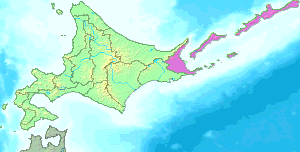
| 描述Nemuro Subprefecture of Hokkaido.png |
English: This map shows the jurisdiction of the Nemuro Subprefecture in Hokkaido with the claimed islands (Northern Territories): Habomai islands, Shikotan, Kunashiri and Etorofu.
日本語:北海道・根室支庁の所管地域を示した図。 |
| 日期 | 2004年10月21日 (原始上傳日期) |
| 來源 |
|
| 作者 | 日文維基百科的Birdman |
授權條款
| 此檔案採用創用CC 姓名標示-相同方式分享 3.0 未在地化版本授權條款。 受免責聲明的約束。 | ||
| ||
| 已新增授權條款標題至此檔案,作為GFDL授權更新的一部份。http://creativecommons.org/licenses/by-sa/3.0/CC BY-SA 3.0Creative Commons Attribution-Share Alike 3.0truetrue |

|
已授權您依據自由軟體基金會發行的無固定段落、封面文字和封底文字GNU自由文件授權條款1.2版或任意後續版本,對本檔進行複製、傳播和/或修改。該協議的副本列在GNU自由文件授權條款中。 受免責聲明的約束。http://www.gnu.org/copyleft/fdl.htmlGFDLGNU Free Documentation Licensetruetrue |
原始上傳日誌
The original description page was here. All following user names refer to ja.wikipedia.
- 2005-09-30 17:34 Birdman 300×152× (14946 bytes) 支庁界変更を反映
- 2005-07-15 15:00 Birdman 300×152× (14974 bytes) 北海道・[[根室支庁]]の所管地域を示した図。{{GFDL}}
- 2004-10-21 20:22 Birdman 300×132× (2087 bytes) 北海道根室支庁の所管区域図。[[:画像:Hokkaido bw.png]]を基に投稿者が作成。
| This file was moved from Japanese Wikipedia.
See below for original file information. | ||||||||||||||||||||||||||||||||||||
| ||||||||||||||||||||||||||||||||||||
|
| ||||||||||||||||||||||||||||||||||||
說明
添加單行說明來描述出檔案所代表的內容
在此檔案描寫的項目
描繪內容
21 10 2004
image/png
檔案歷史
點選日期/時間以檢視該時間的檔案版本。
| 日期/時間 | 縮圖 | 尺寸 | 使用者 | 備註 | |
|---|---|---|---|---|---|
| 目前 | 2020年9月20日 (日) 20:12 | | 300 × 152(15 KB) | OgreBot | (BOT): Reverting to most recent version before archival |
| 2020年9月20日 (日) 20:12 |  | 300 × 152(15 KB) | OgreBot | (BOT): Uploading old version of file from ja.wikipedia; originally uploaded on 2005-07-15 15:00:52 by Birdman | |
| 2020年9月20日 (日) 20:12 |  | 300 × 132(2 KB) | OgreBot | (BOT): Uploading old version of file from ja.wikipedia; originally uploaded on 2004-10-21 20:22:49 by Birdman | |
| 2006年3月25日 (六) 16:17 |  | 300 × 152(15 KB) | Maksim | La bildo estas kopiita de wikipedia:ja. La originala priskribo estas: 北海道・根室支庁の所管地域を示した図。 *[http://www2.demis.nl/mapserver/mapper.asp DEMIS World Map Server]の生成した画像データ(public domain)と、[[: |
檔案用途
沒有使用此檔案的頁面。
全域檔案使用狀況
以下其他 wiki 使用了這個檔案:
- eo.wikipedia.org 的使用狀況
- it.wikipedia.org 的使用狀況
- ja.wikipedia.org 的使用狀況