File:Map_Union_of_Arras_and_Utrecht_1579-en.svg
維基百科,自由的 encyclopedia

此 SVG 檔案的 PNG 預覽的大小:515 × 600 像素。 其他解析度:206 × 240 像素 | 412 × 480 像素 | 660 × 768 像素 | 879 × 1,024 像素 | 1,759 × 2,048 像素 | 749 × 872 像素。
原始檔案 (SVG 檔案,表面大小:749 × 872 像素,檔案大小:140 KB)
摘要
The factual accuracy of 此地圖 or the file name is disputed.
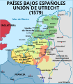
Reason: Cambrai and the Cambrésis did not belong to the Habsburg Netherlands, and wasn't a member of the Union of Arras. |  |
Map of the Union of Utrecht in 1579
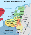
SVG source of Image:Map-1579 Union of Utrecht.png
[編輯]
-
 български
 -
 English
 -
 español
 -
 français (original)
 -
 magyar
 -
 galego
 -
 Nederlands
 -
 norsk
norsk


授權條款
此檔案採用創用CC 姓名標示-相同方式分享 2.5 通用版授權條款。
- 您可以自由:
- 分享 – 複製、發佈和傳播本作品
- 重新修改 – 創作演繹作品
- 惟需遵照下列條件:
- 姓名標示 – 您必須指名出正確的製作者,和提供授權條款的連結,以及表示是否有對內容上做出變更。您可以用任何合理的方式來行動,但不得以任何方式表明授權條款是對您許可或是由您所使用。
- 相同方式分享 – 如果您利用本素材進行再混合、轉換或創作,您必須基於如同原先的相同或兼容的條款,來分布您的貢獻成品。
說明
添加單行說明來描述出檔案所代表的內容
Map of the Spanish Netherlands, the Union of Utrecht and the Union of Arras (1579).
Union von Arras und Utrecht
創用CC姓名標示-相同方式分享2.5通用版 繁體中文 (已轉換拼寫)
image/svg+xml
檔案歷史
點選日期/時間以檢視該時間的檔案版本。
| 日期/時間 | 縮圖 | 尺寸 | 使用者 | 備註 | |
|---|---|---|---|---|---|
| 目前 | 2006年5月31日 (三) 13:23 | | 749 × 872(140 KB) | Moyogo | layers |
| 2005年9月21日 (三) 20:12 |  | 744 × 1,052(138 KB) | Moyogo | SVG source of Image:Map-1579 Union of Utrecht.png |
檔案用途
下列2個頁面有用到此檔案:
全域檔案使用狀況
以下其他 wiki 使用了這個檔案:
- cs.wikipedia.org 的使用狀況
- de.wikipedia.org 的使用狀況
- en.wikipedia.org 的使用狀況
- et.wikipedia.org 的使用狀況
- fa.wikipedia.org 的使用狀況
- it.wikipedia.org 的使用狀況
- ja.wikipedia.org 的使用狀況
- ka.wikipedia.org 的使用狀況
- ko.wikipedia.org 的使用狀況
- pt.wikipedia.org 的使用狀況
- ro.wikipedia.org 的使用狀況
- sh.wikipedia.org 的使用狀況
- sr.wikipedia.org 的使用狀況
- th.wikipedia.org 的使用狀況