File:Lake_Merritt_Oakland_California_panorama.jpg
維基百科,自由的 encyclopedia
此為最大尺寸。
Lake_Merritt_Oakland_California_panorama.jpg (800 × 299 像素,檔案大小:27 KB,MIME 類型:image/jpeg)
| 描述Lake Merritt Oakland California panorama.jpg |
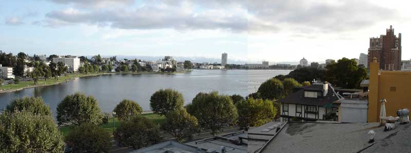
English: Composite of two images taken by Aran Johnson on September 8, 2005 at 18:42 PM local time. Looking west across Lake Merritt. The street visible through the trees in the foreground is Grand Avenue. On the other side of the lake, the road running alongside the curve of the lake is Lakeshore Drive. The low lying building at the far end of the lake just to the right of center, is the Henry J. Kaiser Convention Center. To the right of that, the square building with the peaked roof is the Oakland Court House. The brick building at the far right of the image is the Bellevue-Staten Building a residential high rise dating from the 1920's. |
| 日期 | |
| 來源 | 原始上傳者自己的作品 |
| 作者 | Konky2000 |
| 目標地點 | 37° 48′ 23.32″ 北, 122° 15′ 18.01″ 西 | 位於此地的本圖片與其他圖片: OpenStreetMap |
|---|
授權條款
此檔案採用創用CC 姓名標示-相同方式分享 2.5 通用版授權條款。
- 您可以自由:
- 分享 – 複製、發佈和傳播本作品
- 重新修改 – 創作演繹作品
- 惟需遵照下列條件:
- 姓名標示 – 您必須指名出正確的製作者,和提供授權條款的連結,以及表示是否有對內容上做出變更。您可以用任何合理的方式來行動,但不得以任何方式表明授權條款是對您許可或是由您所使用。
- 相同方式分享 – 如果您利用本素材進行再混合、轉換或創作,您必須基於如同原先的相同或兼容的條款,來分布您的貢獻成品。
原始上傳日誌
The original description page was here. All following user names refer to en.wikipedia.
- 2005-09-09 17:16 Konky2000 800×299× (27702 bytes) Composite of two images taken by Aran Johnson on September 8, 2005 at 18:42 PM local time. Looking west across Lake Merritt. The street visible through the trees in the foreground is Grand Avenue. On the other side of the lake, the road running alongsi
說明
添加單行說明來描述出檔案所代表的內容
創用CC姓名標示-相同方式分享2.5通用版 繁體中文 (已轉換拼寫)
8 9 2005
描述地坐標 中文 (已轉換拼寫)
37°48'23.321"N, 122°15'18.011"W
檔案歷史
點選日期/時間以檢視該時間的檔案版本。
| 日期/時間 | 縮圖 | 尺寸 | 使用者 | 備註 | |
|---|---|---|---|---|---|
| 目前 | 2009年6月19日 (五) 16:35 | 800 × 299(27 KB) | File Upload Bot (Magnus Manske) | {{BotMoveToCommons|en.wikipedia|year={{subst:CURRENTYEAR}}|month={{subst:CURRENTMONTHNAME}}|day={{subst:CURRENTDAY}}}} {{Information |Description={{en|Composite of two images taken by Aran Johnson on September 8, 2005 at 18:42 PM local time. Looking wes |
檔案用途
下列頁面有用到此檔案:
全域檔案使用狀況
以下其他 wiki 使用了這個檔案:
- ar.wikipedia.org 的使用狀況
- arz.wikipedia.org 的使用狀況
- be.wikipedia.org 的使用狀況
- bg.wikipedia.org 的使用狀況
- ca.wikipedia.org 的使用狀況
- ce.wikipedia.org 的使用狀況
- cs.wikipedia.org 的使用狀況
- cy.wikipedia.org 的使用狀況
- de.wikipedia.org 的使用狀況
- el.wikipedia.org 的使用狀況
- en.wikipedia.org 的使用狀況
- en.wikivoyage.org 的使用狀況
- fr.wikipedia.org 的使用狀況
- ga.wikipedia.org 的使用狀況
- gl.wikipedia.org 的使用狀況
- hu.wikipedia.org 的使用狀況
- hy.wikipedia.org 的使用狀況
- ml.wikipedia.org 的使用狀況
- mzn.wikipedia.org 的使用狀況
- nl.wikipedia.org 的使用狀況
- no.wikipedia.org 的使用狀況
- oc.wikipedia.org 的使用狀況
- os.wikipedia.org 的使用狀況
- pl.wikipedia.org 的使用狀況
- pt.wikipedia.org 的使用狀況
- ru.wikipedia.org 的使用狀況
- sr.wikipedia.org 的使用狀況
- th.wikipedia.org 的使用狀況
- tl.wikipedia.org 的使用狀況
- tr.wikipedia.org 的使用狀況
- tt.wikipedia.org 的使用狀況
- ur.wikipedia.org 的使用狀況
- www.wikidata.org 的使用狀況
詮釋資料
此檔案中包含其他資訊,這些資訊可能是由數位相機或掃描器在建立或數位化過程中所新增的。若檔案自原始狀態已被修改,一些詳細資料可能無法完整反映出已修改的檔案。
| _error | 0 |
|---|