File:Compare_world_low_high_res.png
維基百科,自由的 encyclopedia
此為最大尺寸。
Compare_world_low_high_res.png (655 × 267 像素,檔案大小:51 KB,MIME 類型:image/png)
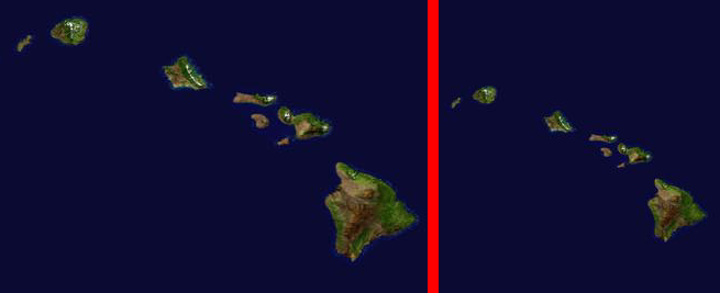
This is a comparison of the Southern Hawaiian Islands in actual pixels from:
Image:Whole world - land and oceans_12000.jpg - To the left and Image:Whole world - land and oceans.jpg - To the right
あなたはログインしていません。あなたのIPアドレスはこの項目の履歴に記録されます
| 描述Compare world low high res.png | Satellite composition of the whole Earth's surface. |
| 日期 | image released 11. Feb. 2002 |
| 來源 |
NASA - Visible Earth, images combined from modifications by Dbenbenn and HighInBC |
| 作者 | NASA/Goddard Space Flight Center |
| 授權許可 (重用此檔案) |
Copyright information from http://visibleearth.nasa.gov/useterms.php - With the exception of images produced by the SeaWiFS, QuickBird, and IKONOS instruments all images on the Visible Earth are governed by NASA's Terms of Use below. [...] For all non-private uses, NASA's Terms Of Use are as follows: 1. The imagery is free of licensing fees 2. NASA requires that they be provided a credit as the owners of the imagery [...] |
| 其他版本 | Image:Whole world - land and oceans 12000.jpg(source left) and Image:Whole world - land and oceans.jpg(source right). |
| Public domainPublic domainfalsefalse |
| 本作品由NASA創作,屬於公有領域。根據NASA的版權政策:“NASA的創作除非另有聲明否則不受版權保護。”(參見:Template:PD-USGov/zh,NASA版權政策或JPL圖像使用政策) | ||
 |
警告:
|
說明
添加單行說明來描述出檔案所代表的內容
在此檔案描寫的項目
描繪內容
image/png
52,321 位元組
267 像素
655 像素
檔案歷史
點選日期/時間以檢視該時間的檔案版本。
| 日期/時間 | 縮圖 | 尺寸 | 使用者 | 備註 | |
|---|---|---|---|---|---|
| 目前 | 2006年8月23日 (三) 17:34 | 655 × 267(51 KB) | HInBC | This is a comparison of the Southern Hawaiian Islands in actual pixels from: Image:Whole world - land and oceans_12000.jpg - '''To the left''' and Image:Whole world - land and oceans.jpg - '''To the right''' {{Information| |Description = |
檔案用途
沒有使用此檔案的頁面。
全域檔案使用狀況
以下其他 wiki 使用了這個檔案: