File:Carmen_1974_track.png
維基百科,自由的 encyclopedia
預覽大小:800 × 495 像素。 其他解析度:320 × 198 像素 | 640 × 396 像素 | 1,024 × 633 像素。
原始檔案 (1,024 × 633 像素,檔案大小:439 KB,MIME 類型:image/png)
摘要
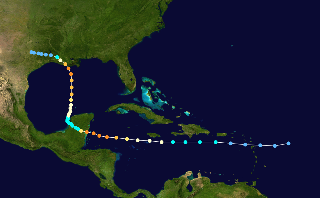
| 描述Carmen 1974 track.png |
English: Hurricane Carmen track. Uses the color scheme from the Saffir-Simpson Hurricane Scale. The points show the location of each storm at six-hour intervals. The colour represents the storm's maximum sustained wind speeds as classified in the Saffir-Simpson Hurricane Scale (see below), and the shape of the data points represent the nature of the storm.
Storm type |
| 日期 | August 29–September 10, 1974 |
| 來源 | Created using Wikipedia:WikiProject Tropical cyclones/Tracks. The background image was created by NASA. The tracking data is from the National Hurricane Center's Atlantic hurricane database |
| 作者 | Nilfanion |
授權條款:
| Public domainPublic domainfalsefalse |
| 此作品已由其作者,Nilfanion,釋出至公有領域。此授權條款在全世界均適用。 這可能在某些國家不合法,如果是的話: Nilfanion授予任何人有權利使用此作品於任何用途,除受法律約束外,不受任何限制。 |
說明
添加單行說明來描述出檔案所代表的內容
在此檔案描寫的項目
描繪內容
image/png
449,025 位元組
633 像素
1,024 像素
檔案歷史
點選日期/時間以檢視該時間的檔案版本。
| 日期/時間 | 縮圖 | 尺寸 | 使用者 | 備註 | |
|---|---|---|---|---|---|
| 目前 | 2006年7月13日 (四) 18:19 | | 1,024 × 633(439 KB) | Nilfanion | |
| 2005年11月11日 (五) 17:32 |  | 1,024 × 633(439 KB) | Jdorje~commonswiki | {{Hurricane auto track map|Hurricane Carmen (1974)}} |
檔案用途
全域檔案使用狀況
以下其他 wiki 使用了這個檔案:
- en.wikipedia.org 的使用狀況
- fi.wikipedia.org 的使用狀況
- fr.wikipedia.org 的使用狀況
- pt.wikipedia.org 的使用狀況