| 名稱
|
年代
|
公布
|
位置
|
描述
|
圖片
|
| 安貝利大廈(Ann Baillie Building)[2][3]
|
1904
|
1997
|
金斯頓
44°13′25.56″N 76°29′32.53″W
|
|
|
| 貝勒瑜之家(Bellevue House)[4]
|
1841
|
1995
|
金斯頓
44°13′22″N 76°30′12″W
|
|

|
| 卡塔拉基公墓(Cataraqui Cemetery)[5][6]
|
1850
|
2011
|
金斯頓
44°15′52″N 76°32′28″W
|
|

|
| 伊莉莎白小屋(Elizabeth Cottage)[7]
|
1843
|
1993
|
金斯頓
44°13′54.46″N 76°29′20.26″W
|
|

|
| 芳堤娜堡(Fort Frontenac)[8][9]
|
1673
|
1923
|
金斯頓
44°14′00″N 76°28′43″W
|
|

|
| 亨利堡(Fort Henry)[10][11]
|
1840
|
1923
|
金斯頓
44°13′48.95″N 76°27′34.85″W
|
|

|
| 芳堤娜縣法院(Frontenac County Court House)[12][13]
|
1858
|
1980
|
金斯頓
44.227777°N 76.489777°W / 44.227777; -76.489777 (Frontenac County Court House)
|
|

|
| 金斯頓市政廳(Kingston City Hall)和集市廣場[14][15]
|
1844
|
1961
|
金斯頓
44°13′47.68″N 76°28′50.1″W
|
|

|
| 金斯頓海關(Kingston Customs House)[16][17]
|
1859
|
1971
|
金斯頓
44°13′46.64″N 76°28′56.45″W
|
|

|
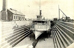
| 金斯頓干船塢(Kingston Dry Dock)[18][19]
|
1892
|
1978
|
金斯頓
44°13′30.63″N 76°29′0.16″W
|
|
|
| 金士頓防禦工事(Kingston Fortifications)[20][21]
|
1840
|
1989
|
金斯頓
44.222275°N 76.490357°W / 44.222275; -76.490357 (Kingston Fortifications)
|
|

|
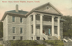
| 金斯頓總醫院(Kingston General Hospital)[22][23]
|
1833-1924
|
1995
|
金斯頓
44°13′27″N 076°29′35″W
|
|
|
| 金斯頓海軍船塢(Kingston Navy Yard)[24]
|
1788
|
1928
|
金斯頓
44°13′44″N 76°28′07″W
|
|

|
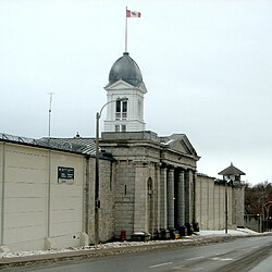
| 金斯頓監獄(Kingston Penitentiary)[25][26]
|
1835
|
1990
|
金斯頓
44.22069°N 76.51340°W / 44.22069; -76.51340 (Kingston Penitentiary)
|
|
|
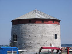
| 默尼塔(Murney Tower)[27][28]
|
1846
|
1930
|
金斯頓
44.22228°N 76.490582°W / 44.22228; -76.490582 (Murney Tower)
|
|

|
| 金斯敦老郵局(Old Kingston Post Office)[29][30]
|
1859
|
1971
|
金斯頓
44°13′47.91″N 76°28′58.89″W
|
|

|
| 弗雷德里克角大廈(Point Frederick Buildings)[31][32]
|
|
1973
|
金斯頓
44°13′40.73″N 76°28′10.12″W
|
|

|
| 麗都運河(Rideau Canal)[33][34]
|
1837
|
1925
|
渥太華到金斯頓
45°25′33″N 75°41′50″W
|
|

|
| 玫瑰草坪(Roselawn)[35][36]
|
1841
|
1969
|
金斯頓
44°13′31.98″N 76°30′36.66″W
|
|

|
| 淺灘塔(Shoal Tower)[37][38]
|
1847
|
1930
|
金斯頓
44°13′43.69″N 76°28′41.14″W
|
|
|
| 麥克唐納爵士墓(Sir John A. Macdonald Gravesite)[39][40]
|
1891
|
1938
|
金斯頓
44.262080°N 76.542188°W / 44.262080; -76.542188 (Sir John A. Macdonald Gravesite)
|
|
|
| 1812年戰爭沉船(War of 1812 Shipwrecks)[41]
|
1814
|
2015
|
金斯頓
44.231003°N 76.452241°W / 44.231003; -76.452241
|
|
|


.jpg)


.JPG)

