巴塘海峡
来自维基百科,自由的百科全书
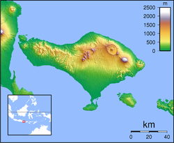
巴塘海峡是印度尼西亚的海峡,位于峇厘岛东南和珀尼达岛之间,约长60公里、宽20公里。第二次世界大战期间,该海峡在1942年2月发生巴塘海峡战役,大日本帝国在此击溃同盟国海军,随后占领峇厘岛。[1][2][3]
| 巴塘海峡 Selat Badung(印尼语) | |
|---|---|
| 坐标 | 8°37′50″S 115°23′17″E |
| 类型 | 海峡 |
| 所在国家 | |
| 最大长度 | 60千米(37英里) |
| 最大宽度 | 20千米(12英里) |
| 参考 | Selat Badung: Indonesia |
 | |
参考资料
Wikiwand in your browser!
Seamless Wikipedia browsing. On steroids.
Every time you click a link to Wikipedia, Wiktionary or Wikiquote in your browser's search results, it will show the modern Wikiwand interface.
Wikiwand extension is a five stars, simple, with minimum permission required to keep your browsing private, safe and transparent.

