圣弗朗西斯河
美国河流 来自维基百科,自由的百科全书
圣弗朗西斯河(英语:St. Francis River)是密西西比河的一条支流,长约426英里(686千米)[3],位于美国密苏里州的东南部和阿肯色州东北部。
此条目的引用需要清理,使其符合格式。 (2018年2月13日) |
| 圣弗朗西斯河 St. Francis River | |
|---|---|
 位于阿肯色州莱克城的圣弗朗西斯河 | |
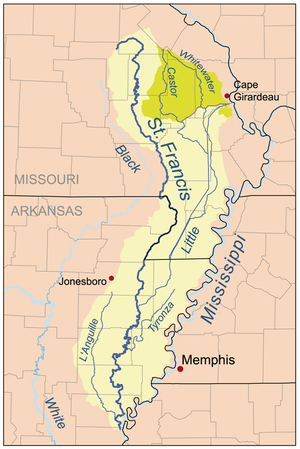
 Map of the St. Francis River watershed. The Castor/Whitewater headwaters (darker shade on the map) were historically part of the St. Francis watershed but are now diverted to the Mississippi. | |
| 国家 | |
| 州 | |
| 地区 | Ozark Plateau、Mississippi Alluvial Plain |
| 区 | St. Francois Mountains、Crowleys Ridge |
| 流域 | |
| 源头 | Elephant Rocks State Park |
| • 位置 | 密苏里州Ozark Plateau菲利普斯县艾昂县 |
| • 海拔 | 1,568英尺(478米) |
| 河口 | 密西西比河 |
| • 位置 | 阿肯色州Mississippi Alluvial Plain菲利普斯县海伦娜-西海伦娜附近 |
| • 坐标 | 34°37′28″N 90°35′31″W[1] |
| • 海拔 | 171英尺(52米)[1] |
| 流域面积 | 7,550 sq mi(19,600 km2)[2] |
| 城市 | Farmington, Missouri、Fisk, Missouri、Lake City, Arkansas、Marked Tree, Arkansas |
| 本貌 | |
| 长度 | 426 mi(686 km) |
| 特征 | |
| 左岸支流 | 小圣弗朗西斯河、Twelvemile Creek、Blue Spring、Mingo Ditch、Little River |
| 右岸支流 | Stouts Creek、Marble Creek、Big Creek、Otter Creek、L'Anguille River |
参考文献
外部链接
Wikiwand - on
Seamless Wikipedia browsing. On steroids.
