File:Michigan_US_Congressional_District_3_(since_2013).tif
维基百科,自由的 encyclopedia

此TIF文件的PNG预览的大小:800 × 382像素。 其他分辨率:320 × 153像素 | 640 × 306像素 | 1,024 × 489像素 | 2,110 × 1,008像素。
原始文件 (2,110 × 1,008像素,文件大小:2.9 MB,MIME类型:image/tiff)
摘要
| 描述Michigan US Congressional District 3 (since 2013).tif |
English: Boundaries for Michigan’s 3rd United States Federal Congressional District. |
| 日期 | |
| 来源 | GIS shapefile data created by the United States Department of the Interior, as part of the "1 Million Scale" geospatial data project. Retrieved from: http://nationalatlas.gov/atlasftp-1m.html?openChapters=#chpbound |
| 作者 | 1: GIS (congressional districts, 2013) shapefile data was created by the United States Department of the Interior. 2: Data was rendered using ArcGIS® software by Esri. 3: File developed for use on Wikipedia and elsewhere by 7partparadigm. |
许可协议
| Public domainPublic domainfalsefalse |
本地图取自美国国家地图集的某个版本。正如几乎所有美国联邦政府作品一样,来自国家地图集的作品在美国属于公有领域。
在线访问:NationalAtlas.gov | 1970年印刷版:国会图书馆、Perry-Castañeda图书馆 čeština | Deutsch | English | français | Bahasa Indonesia | italiano | македонски | മലയാളം | sicilianu | 中文 | 中文(简体) | 中文(繁體) | +/− |
文件历史
点击某个日期/时间查看对应时刻的文件。
| 日期/时间 | 缩略图 | 大小 | 用户 | 备注 | |
|---|---|---|---|---|---|
| 当前 | 2014年5月15日 (四) 02:53 | 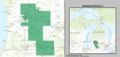 | 2,110 × 1,008(2.9 MB) | 7partparadigm | User created page with UploadWizard |
文件用途
以下页面使用本文件:
全域文件用途
以下其他wiki使用此文件:
- en.wikipedia.org上的用途
- fr.wikipedia.org上的用途
- hu.wikipedia.org上的用途
- simple.wikipedia.org上的用途
- www.wikidata.org上的用途
元数据
此文件中包含有扩展的信息。这些信息可能是由数码相机或扫描仪在创建或数字化过程中所添加。
如果此文件的源文件已经被修改,一些信息在修改后的文件中将不能完全反映出来。
| 宽度 | 2,110 px |
|---|---|
| 高度 | 1,008 px |
| 压缩方案 | LZW |
| 像素构成 | RGB |
| 方向 | 正常 |
| 色彩组分数 | 4 |
| 每带行数 | 1 |
| 水平分辨率 | 96.012 dpi |
| 垂直分辨率 | 96.012 dpi |
| 数据排布 | 大块格式 |