File:Italy_c_1810.png
维基百科,自由的 encyclopedia
本预览的尺寸:413 × 599像素。 其他分辨率:165 × 240像素 | 331 × 480像素 | 529 × 768像素 | 1,251 × 1,814像素。
原始文件 (1,251 × 1,814像素,文件大小:90 KB,MIME类型:image/png)
摘要
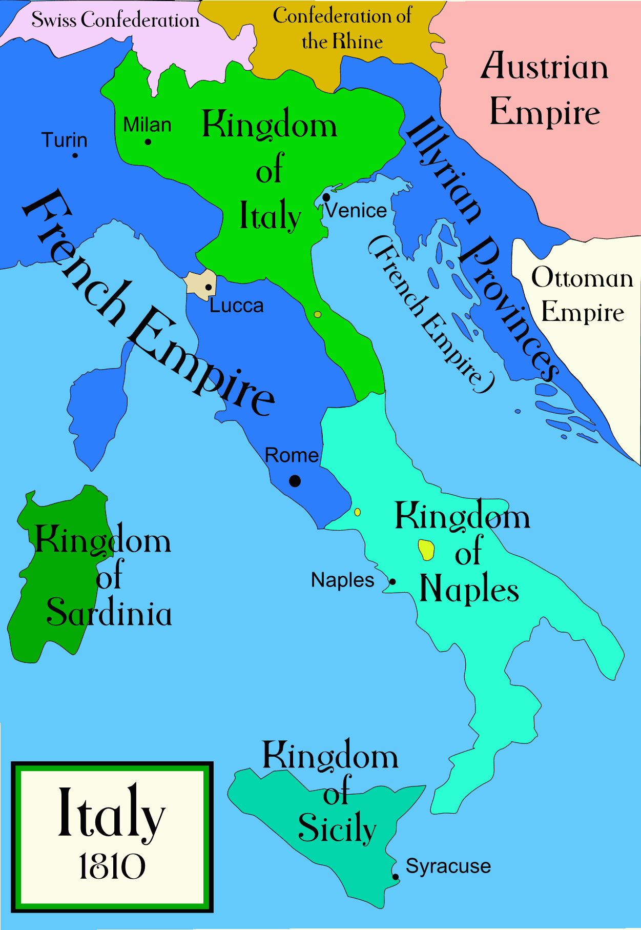
Political map of Italy in the years around 1810, during the Napoleonic era, created by MapMaster. This is a companion map to Image:Italy 1796.png and Image:Italy 1494_v2.png. An SVG version of this map (with Slovenian labels) can be found at Image:Italija_1810_Slovenscina.svg.
Spanish version: File:Italy c 1810-es.png, uploaded by Aibdescalzo

|
此historical map图片可使用矢量图形重新创建为SVG文件。这具有很多好处;更多信息请参见共享资源:待清理媒体。如果存在此图片的SVG格式,请将其上传,然后将此模板替换为
{{vector version available|新图片名称}}。
建议您将SVG命名为“Italy c 1810.svg”,这样在使用Vector version available(或Vva)模板时就不需要填写新图片名称参数。 |
References
- Bjorklund, Oddvar; Holmboe, Haakon; Rohr, Anders (1970) Historical Atlas of the World, Barnes & Noble, NY, SBN: 389-00253-4.
- Other maps, including Image:1french-empire1811.jpg from the 1912 Cambridge Modern History Atlas.
许可协议
我,本作品著作权人,特此采用以下许可协议发表本作品:

|
已授权您依据自由软件基金会发行的无固定段落及封面封底文字(Invariant Sections, Front-Cover Texts, and Back-Cover Texts)的GNU自由文件许可协议1.2版或任意后续版本的条款,复制、传播和/或修改本文件。该协议的副本请见“GNU Free Documentation License”。http://www.gnu.org/copyleft/fdl.htmlGFDLGNU Free Documentation Licensetruetrue |
| 本文件采用知识共享署名-相同方式共享 3.0 未本地化版本许可协议授权。 | ||
| ||
| 本许可协议标签作为GFDL许可协议更新的组成部分被添加至本文件。http://creativecommons.org/licenses/by-sa/3.0/CC BY-SA 3.0Creative Commons Attribution-Share Alike 3.0truetrue |
您可以选择您需要的许可协议。
derivative works
Derivative works of this file:
[编辑]
-
 阿拉伯语
阿拉伯语 -
 英语
英语 -
 西班牙语
西班牙语 -
 韩语
韩语


说明
添加一行文字以描述该文件所表现的内容
此文件中描述的项目
描绘内容
GNU自由文档许可证1.2或更高版本 简体中文(已转写)
知识共享署名-相同方式共享3.0未本地化版本 简体中文(已转写)
文件历史
点击某个日期/时间查看对应时刻的文件。
| 日期/时间 | 缩略图 | 大小 | 用户 | 备注 | |
|---|---|---|---|---|---|
| 当前 | 2009年4月21日 (二) 01:32 | | 1,251 × 1,814(90 KB) | Capmo | pallette reduction to 64 colours |
| 2006年10月19日 (四) 04:01 |  | 1,251 × 1,814(385 KB) | MapMaster | Further improvements to bring it into line with Image:Italy 1796.png | |
| 2006年10月13日 (五) 12:41 |  | 1,251 × 1,814(403 KB) | MapMaster | Map was slightly improved. | |
| 2006年10月13日 (五) 12:00 |  | 1,265 × 1,816(402 KB) | MapMaster | Political map of Italy in the years around 1810, during the Napoleonic era, created by MapMaster. |
文件用途
以下2个页面使用本文件:
全域文件用途
以下其他wiki使用此文件:
- an.wikipedia.org上的用途
- be.wikipedia.org上的用途
- br.wikipedia.org上的用途
- ceb.wikipedia.org上的用途
- cs.wikipedia.org上的用途
- da.wikipedia.org上的用途
- de.wikipedia.org上的用途
- en.wikipedia.org上的用途
- eo.wikipedia.org上的用途
- es.wikipedia.org上的用途
- et.wikipedia.org上的用途
- fa.wikipedia.org上的用途
- fr.wikipedia.org上的用途
- he.wikipedia.org上的用途
- hi.wikipedia.org上的用途
- hr.wikipedia.org上的用途
- hu.wikipedia.org上的用途
- id.wikipedia.org上的用途
- is.wikipedia.org上的用途
- it.wikipedia.org上的用途
- ja.wikipedia.org上的用途
查看此文件的更多全域用途。