File:First_global_geologic_map_of_Titan_(PIA23174).jpg
维基百科,自由的 encyclopedia
原始文件 (4,608 × 2,732像素,文件大小:6.83 MB,MIME类型:image/jpeg)
 | 这个file中的所有图片名上传在JPEG格式,即使它包含非照片数据。该信息可以以PNG或SVG格式更有效或更准确地存储。如果可能,请上传此图像的PNG或SVG版本,没有压缩失真,源自非JPEG源(或去除现存的失真)。完成后,请使用{{Superseded|NewImage.ext}}标记JPEG版本并删除此标记。此标签不应应用于照片或扫描件。如需更多信息,请参阅{{BadJPEG}}。 |  |
摘要
| 描述First global geologic map of Titan (PIA23174).jpg |
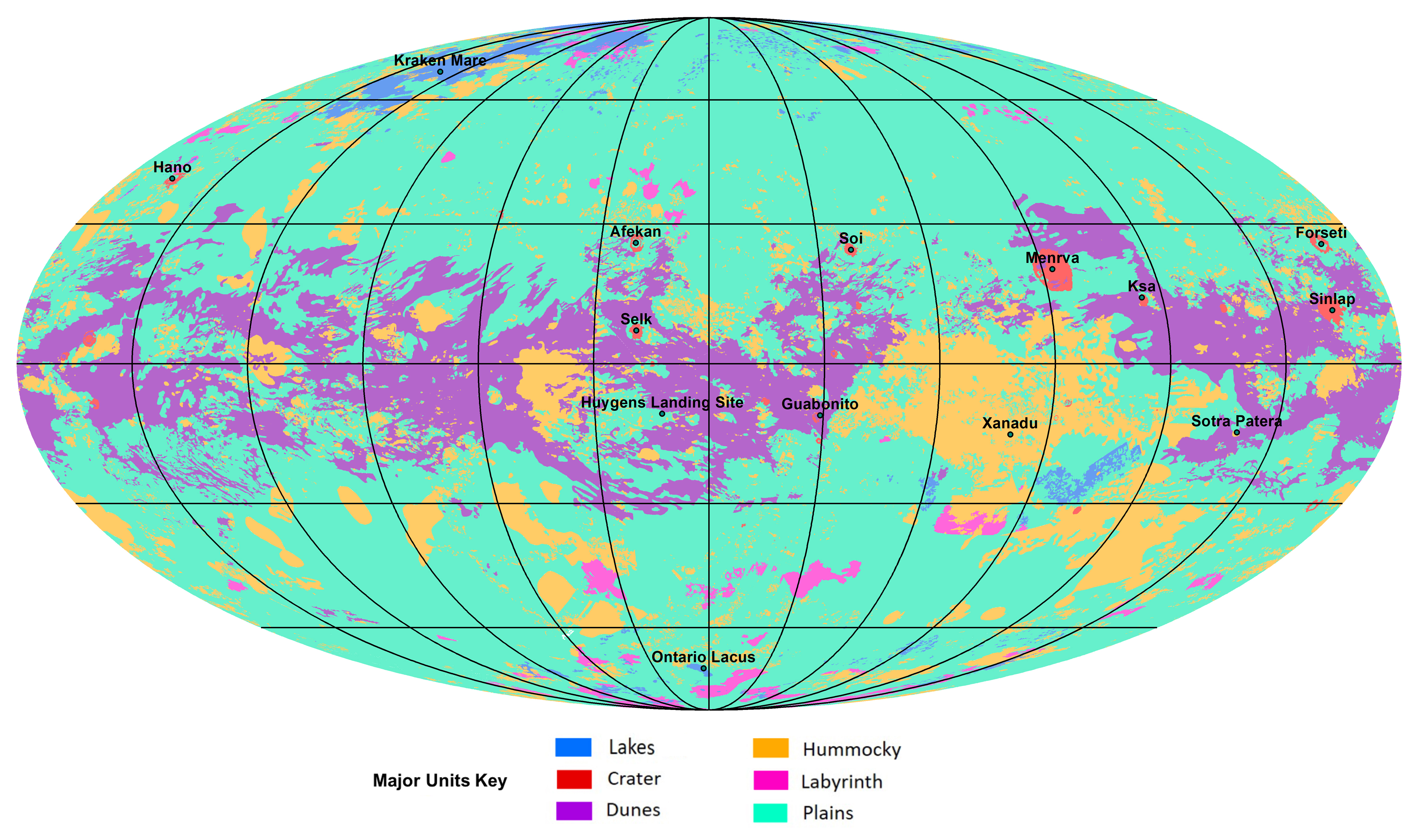
English: The first global geologic map of Saturn's largest moon, Titan, is based on radar and visible and infrared images from NASA's Cassini mission, which orbited Saturn from 2004 to 2017.
Black lines mark 30 degrees of latitude and longitude. Map is in Mollweide projection, a global view that attempts to minimize the size or area distortion, especially at the poles (although shapes are increasingly distorted away from the center of the map). It is centered on 0 degrees latitude, 180 degrees longitude. Map scale is 1:20,000,000. In the annotated figure, the map is labeled with several of the named surface features. Also located is the landing site of the European Space Agency's (ESA) Huygens Probe, part of NASA's Cassini mission. The map legend colors represent the broad types of geologic units found on Titan: plains (broad, relatively flat regions), labyrinth (tectonically disrupted regions often containing fluvial channels), hummocky (hilly, with some mountains), dunes (mostly linear dunes, produced by winds in Titan's atmosphere), craters (formed by impacts) and lakes (regions now or previously filled with liquid methane or ethane). Titan is the only planetary body in our solar system other than Earth known to have stable liquid on its surface — methane and ethane. The map was developed using Cassini radar data and Imaging Science Subsystem (ISS) images. |
| 日期 | |
| 来源 | NASA Jet Propulsion Laboratory https://www.jpl.nasa.gov/spaceimages/details.php?id=PIA23174 |
| 作者 | NASA/JPL-Caltech/ASU |
许可协议
| Public domainPublic domainfalsefalse |
| 本文件完全由NASA创作,在美国属于公有领域。根据NASA的版权方针,NASA的材料除非另有声明否则不受版权保护。(参见Template:PD-USGov/zh、NASA版权方针页面或JPL图片使用方针。) | ||
 |
警告:
|
说明
此文件中描述的项目
描绘内容
文件历史
点击某个日期/时间查看对应时刻的文件。
| 日期/时间 | 缩略图 | 大小 | 用户 | 备注 | |
|---|---|---|---|---|---|
| 当前 | 2019年11月18日 (一) 23:55 | | 4,608 × 2,732(6.83 MB) | Bri | User created page with UploadWizard |
文件用途
以下页面使用本文件:
全域文件用途
以下其他wiki使用此文件:
- en.wikipedia.org上的用途
- fr.wikibooks.org上的用途
- mk.wikipedia.org上的用途
- nl.wikipedia.org上的用途
- ru.wikipedia.org上的用途
元数据
此文件中包含有扩展的信息。这些信息可能是由数码相机或扫描仪在创建或数字化过程中所添加。
如果此文件的源文件已经被修改,一些信息在修改后的文件中将不能完全反映出来。
| 方向 | 正常 |
|---|---|
| 水平分辨率 | 300 dpi |
| 垂直分辨率 | 300 dpi |
| 使用软件 | Adobe Photoshop CS5 Macintosh |
| 文件修改日期时间 | 2019年11月14日 (四) 15:21 |
| 色彩空间 | 未标定 |
.jpg)