File:Br-map1.jpg
维基百科,自由的 encyclopedia
此为最大尺寸。
Br-map1.jpg (330 × 354像素,文件大小:34 KB,MIME类型:image/jpeg)
| 描述Br-map1.jpg |
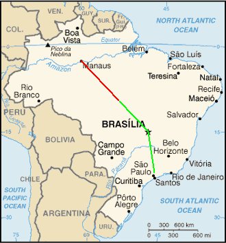
English: Map of Brazil showing the presumed flight paths of Gol Transportes Aéreos Flight 1907 and the Embraer Legacy 600 aircraft that it collided with to the crash site (source: CENIPA Final report)
|
||||||||
| 日期 | |||||||||
| 来源 | Derivative work of File:Brazil-CIA_WFB_Map.png | ||||||||
| 作者 | Crum375 (talk) | ||||||||
| 授权 (二次使用本文件) |
|

说明
添加一行文字以描述该文件所表现的内容
此文件中描述的项目
描绘内容
戈尔航空1907号班机空难 简体中文(已转写)
GNU自由文档许可证1.2或更高版本 简体中文(已转写)
知识共享署名-相同方式共享3.0未本地化版本 简体中文(已转写)
6 10 2006
媒体类型 简体中文(已转写)
image/jpeg
数据大小 简体中文(已转写)
34,778 字节
354 像素
330 像素
文件历史
点击某个日期/时间查看对应时刻的文件。
| 日期/时间 | 缩略图 | 大小 | 用户 | 备注 | |
|---|---|---|---|---|---|
| 当前 | 2006年10月6日 (五) 17:21 | | 330 × 354(34 KB) | Xamã~commonswiki | Original was Br-map.gif from WikiCommmons, placed crash coords 10.29S 53.15W, drew lines between Sao Paulo, Manaus and Brasilia, to crash coord location, per GoogleMaps as reference |
文件用途
以下页面使用本文件:
全域文件用途
以下其他wiki使用此文件:
- de.wikipedia.org上的用途
- en.wikipedia.org上的用途
- es.wikipedia.org上的用途
- fr.wikipedia.org上的用途
- it.wikipedia.org上的用途
- ja.wikipedia.org上的用途
- nl.wikipedia.org上的用途
- pt.wikipedia.org上的用途
- ru.wikipedia.org上的用途
元数据
此文件中包含有扩展的信息。这些信息可能是由数码相机或扫描仪在创建或数字化过程中所添加。
如果此文件的源文件已经被修改,一些信息在修改后的文件中将不能完全反映出来。
| _error | 0 |
|---|