File:AMH-6670-NA_Map_of_the_island_of_Formosa.jpg
维基百科,自由的 encyclopedia
本预览的尺寸:800 × 554像素。 其他分辨率:320 × 222像素 | 640 × 443像素 | 1,024 × 709像素 | 1,280 × 886像素 | 2,400 × 1,662像素。
原始文件 (2,400 × 1,662像素,文件大小:691 KB,MIME类型:image/jpeg)
摘要
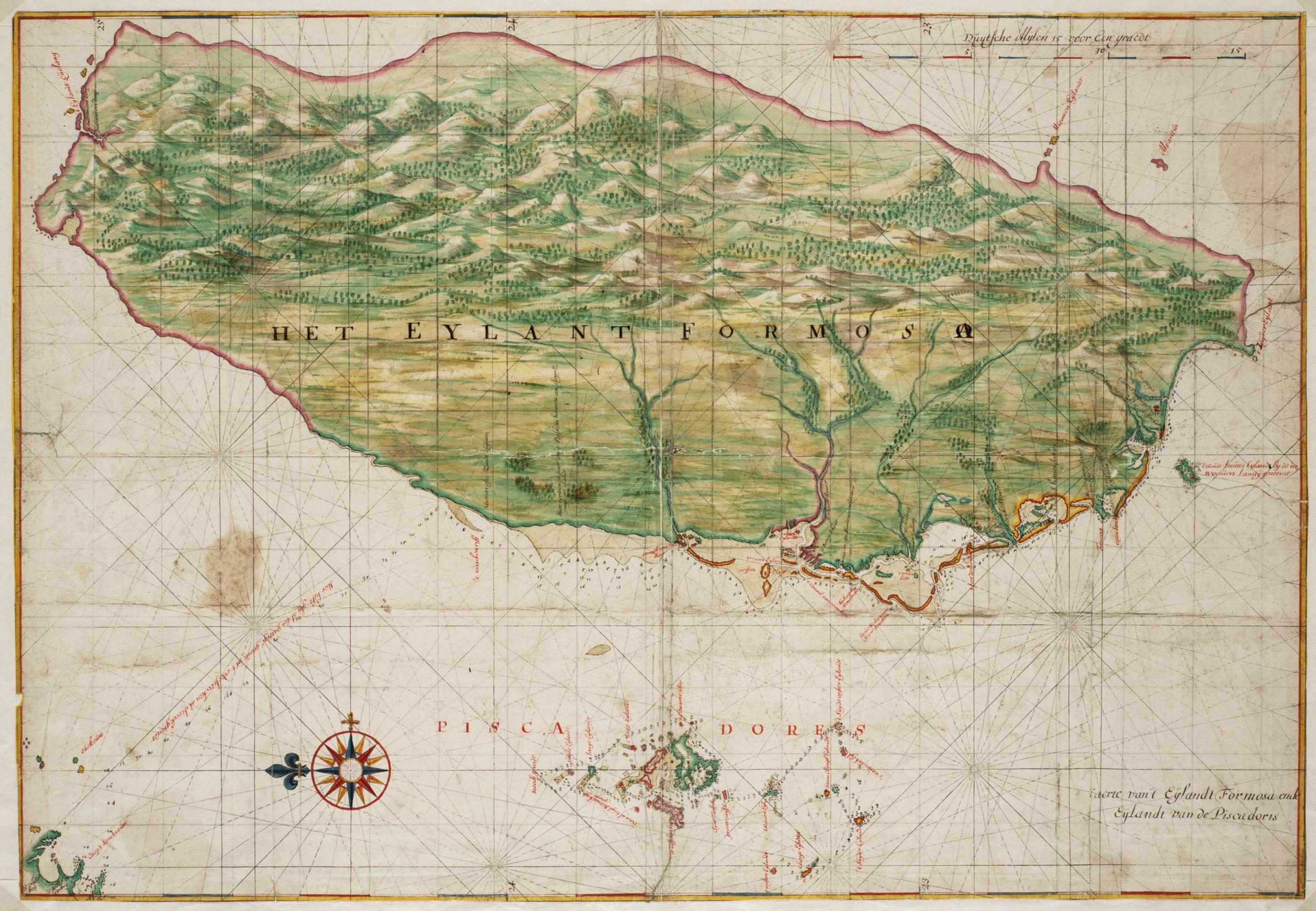
Nederlands: Kaart van het eiland Formosa
English: Map of the island of Formosa( |
||||||||||||||||||||||||
|---|---|---|---|---|---|---|---|---|---|---|---|---|---|---|---|---|---|---|---|---|---|---|---|---|
| 作者 |
creator QS:P170,Q2232496
Nederlands: Johannes Vingboons (landmeter / kaartenmaker)
English: Johannes Vingboons (land surveyor / mapmaker) |
|||||||||||||||||||||||
| 标题 |
Nederlands: Kaart van het eiland Formosa
English: Map of the island of Formosa |
|||||||||||||||||||||||
| 描述 |
Nederlands: Titel catalogus Leupe (Nationaal Archief): Kaart van de kusten van Formosa en de Pescadores.
Lodingen aangegeven op de kaart. Op de achterzijde zijn strookjes papier geplakt met daarop letters en woorden geschreven die echter geen samenhangende tekst vormen. De contouren van Formosa en de Pescadores zijn op deze kaart exact dezelfde als die in de Atlas Blaeu-Van der Hem uit de Österreichische Nationalbibiothek , Wenen, inv. nr. Van der Hem 41:02.English: Title in the Leupe catalogue (National Archives): Kaart van de kusten van Formosa en de Pescadores.
Soundings indicated on the chart. Strips of paper have been pasted on the reverse. The strips bear letters and words, but these do not combine into a coherent text. The outlines of The island Formosa and the Pescadores on this map are exactly the same as the ones on the map in the Atlas Blaeu-Van der Hem from the Österreichische Nationalbibiothek , Vienna, inv. nr. Van der Hem 41:02. |
|||||||||||||||||||||||
| 日期 |
约1665年 date QS:P571,+1665-00-00T00:00:00Z/9,P1480,Q5727902 |
|||||||||||||||||||||||
| 表现形式 |
Nederlands: aquarel/waterverf op papier
English: watercolour on paper |
|||||||||||||||||||||||
| 尺寸 |
高度:68厘米;宽度:47厘米 dimensions QS:P2048,68U174728 dimensions QS:P2049,47U174728 |
|||||||||||||||||||||||
| 藏于 |
institution QS:P195,Q1857081 |
|||||||||||||||||||||||
| 登录号 |
NL-HaNA_4.VELH_619.52 (old number: VELH0619.52) |
|||||||||||||||||||||||
| 题记 |
Het Eylant Formosa
|
|||||||||||||||||||||||
| 备注 |
English: Subjects: chart / map / plan, compass / dial
Nederlands: Onderwerpen: plattegrond / kaart, kompas / windroos
English: Post: this image is related to a VOC trading post called Chi-lung |
|||||||||||||||||||||||
| 来源/摄影师 |
|
|||||||||||||||||||||||
| 授权 (二次使用本文件) |
|
|||||||||||||||||||||||
| 其他版本 |
|
|||||||||||||||||||||||


| 物体位置 | 25° 07′ 49.88″ 北, 121° 44′ 24.32″ 东 | 在以下服务上查看本图像和附近其他图像: OpenStreetMap |
|---|
说明
添加一行文字以描述该文件所表现的内容
此文件中描述的项目
描绘内容
维基媒体VRTS工单号码 简体中文(已转写)
描述地坐标 中文(已转写)
25°7'49.876"N, 121°44'24.317"E
媒体类型 简体中文(已转写)
image/jpeg
数据大小 简体中文(已转写)
707,779 字节
1,662 像素
2,400 像素
文件历史
点击某个日期/时间查看对应时刻的文件。
| 日期/时间 | 缩略图 | 大小 | 用户 | 备注 | |
|---|---|---|---|---|---|
| 当前 | 2014年6月11日 (三) 09:39 | | 2,400 × 1,662(691 KB) | HuskyBot | == {{int:filedesc}} == {{Artwork |title = {{nl|1=Kaart van het eiland Formosa}} {{en|1=Map of the island of Formosa}} |description = {{nl|1=Titel catalogus Leupe (Nationaal Archief): ''Kaart van de kusten van F... |
文件用途
以下页面使用本文件:
全域文件用途
以下其他wiki使用此文件:
- ast.wikipedia.org上的用途
- en.wikipedia.org上的用途
- es.wikipedia.org上的用途
- fy.wikipedia.org上的用途
- nl.wikipedia.org上的用途
- tr.wikipedia.org上的用途