畢士利區
来自维基百科,自由的百科全书
畢士利區(英語:London Borough of Bexley,ⓘ)是英國英格蘭大倫敦外倫敦的自治市,人口221,600,面積60.56km²。
| 畢士利區 London Borough of Bexley | |
|---|---|
| 自治市鎮(區) | |
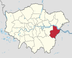
 畢士利區在大倫敦的位置 | |
| 坐標:51°27′20″N 0°09′13″E | |
| 國家 | 英國 |
| 構成國 | 英格蘭 |
| 郡及區域 | 大倫敦 |
| 行政總部 | 畢士利希思百老匯 |
| 政府 | |
| • 類型 | Leader & Cabinet |
| • 市長 | Nigel Betts |
| • 立法 | |
| • 議員 | John Austin Derek Conway David Evennett |
| • 倫敦議會成員 | 畢士利與布朗姆利 James Cleverly |
| 面積 | |
| • 總計 | 60.56 平方公里(23.38 平方哩) |
| 面積排名 | 289 |
| • 排名 | (共354區) |
| ONS編碼 | 00AD |
| 種族 | 英國白人 愛爾蘭人 其他白人 白人-加勒比海黑人 白人-加勒比海非裔 亞裔白人 其他混血兒 印度人 巴基斯坦人 孟加拉人 其他亞裔 加勒比海黑人 非裔黑人 其他黑人 英籍華人 其他 |
| 網站 | www |
畢士利區位於倫敦東部外圍、泰晤士河南岸。畢士利區是1965年時,根據《1963年倫敦政府法案》(London Government Act 1963),由畢士利市自治市(Municipal Borough of Bexley)、艾利斯市自治市(Municipal Borough of Erith)、克雷福城區(Crayford Urban District)與一部份的奇索赫斯特與錫德卡普城區(Chislehurst and Sidcup Urban District)合併而成,是個人口221,600(2006年統計)、面積60.56平方公里、中產階級聚居的郊區市鎮。
畢士利位於大倫敦的最東,其東面的行政區邊界是與根德郡的達特福自治市(Borough of Dartford)相連。
註釋
參考文獻
外部連結
Wikiwand - on
Seamless Wikipedia browsing. On steroids.
