漢諾威省
来自维基百科,自由的百科全书
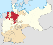
漢諾威省(德語:Provinz Hannover)是1868年至1946年普魯士和普魯士自由邦的一個省分。
| 漢諾威省 Provinz Hannover | |||||||||||
|---|---|---|---|---|---|---|---|---|---|---|---|
| 普魯士的省份 | |||||||||||
| 1868—1946 | |||||||||||
 The Province of Hanover (red), within the Kingdom of Prussia (white), within the German Empire (beige) | |||||||||||
| 坐標:52°22′N 9°43′E | |||||||||||
| 國家 | 普魯士 | ||||||||||
| 首府 | 漢諾威 | ||||||||||
| 面積 | |||||||||||
• 1939 | 38,705平方公里(14,944平方英里) | ||||||||||
| 人口 | |||||||||||
• 1939 | 3.537.390 | ||||||||||
| 歷史 | |||||||||||
• 建立 | 1868 | ||||||||||
• 廢除 | 1946 | ||||||||||
| 行政分區 |
| ||||||||||
| |||||||||||
在普奧戰爭期間,漢諾威王國曾嘗試與其它一些參與德意志邦聯的城邦一同維持中立地位。當1866年6月14日漢諾瓦投票同意動員德意志邦聯軍隊與普魯士作戰的時候,這就被普魯士視為能向漢諾瓦宣戰的藉口。之後不久,漢諾瓦王國很快就被打敗,並被普魯士合併。被罷黜的漢諾威王朝的私人財產則為奧托·馮·俾斯麥提供資金,以利用對付巴伐利亞的路德維希二世。
1946年,英國佔領區將漢諾威省、奧爾登堡、不倫瑞克和紹姆堡-利泊等地組成新的下薩克森州的主要部分,而漢諾威則成為這個新州分的首府。

參見
Wikiwand - on
Seamless Wikipedia browsing. On steroids.


