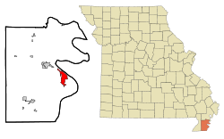
卡拉瑟斯維爾 (密蘇里州)
来自维基百科,自由的百科全书
卡拉瑟斯維爾(英語:Caruthersville)是位於美國密蘇里州佩米斯科特縣的城市。同時該地也是佩米斯科特縣的縣治。
氣候
| 卡拉瑟斯維爾 (密蘇里州),1991–2020年正常值,1898–2012年極端數據 | |||||||||||||
|---|---|---|---|---|---|---|---|---|---|---|---|---|---|
| 月份 | 1月 | 2月 | 3月 | 4月 | 5月 | 6月 | 7月 | 8月 | 9月 | 10月 | 11月 | 12月 | 全年 |
| 歷史最高溫 °F(°C) | 79 (26) |
83 (28) |
93 (34) |
97 (36) |
102 (39) |
109 (43) |
109 (43) |
111 (44) |
108 (42) |
98 (37) |
87 (31) |
79 (26) |
111 (44) |
| 平均高溫 °F(°C) | 46.1 (7.8) |
51.1 (10.6) |
59.9 (15.5) |
70.8 (21.6) |
79.1 (26.2) |
87.5 (30.8) |
90.1 (32.3) |
88.9 (31.6) |
83.0 (28.3) |
72.4 (22.4) |
59.4 (15.2) |
49.0 (9.4) |
69.8 (21.0) |
| 日均氣溫 °F(°C) | 37.9 (3.3) |
41.9 (5.5) |
49.9 (9.9) |
60.4 (15.8) |
69.7 (20.9) |
77.9 (25.5) |
81.1 (27.3) |
79.6 (26.4) |
72.8 (22.7) |
61.5 (16.4) |
49.8 (9.9) |
40.9 (4.9) |
60.3 (15.7) |
| 平均低溫 °F(°C) | 29.6 (−1.3) |
32.7 (0.4) |
39.8 (4.3) |
50.0 (10.0) |
60.4 (15.8) |
68.4 (20.2) |
72.2 (22.3) |
70.2 (21.2) |
62.7 (17.1) |
50.6 (10.3) |
40.1 (4.5) |
32.8 (0.4) |
50.8 (10.4) |
| 歷史最低溫 °F(°C) | −15 (−26) |
−22 (−30) |
5 (−15) |
26 (−3) |
33 (1) |
45 (7) |
54 (12) |
48 (9) |
32 (0) |
20 (−7) |
5 (−15) |
−9 (−23) |
−22 (−30) |
| 平均降水量 吋(mm) | 4.00 (102) |
4.87 (124) |
5.25 (133) |
6.12 (155) |
5.91 (150) |
4.38 (111) |
3.78 (96) |
3.14 (80) |
3.59 (91) |
4.60 (117) |
4.39 (112) |
5.23 (133) |
55.26 (1,404) |
| 平均降水天數(≥ 0.01 in) | 10.5 | 8.2 | 10.3 | 10.7 | 10.0 | 9.2 | 7.6 | 5.6 | 7.1 | 6.8 | 9.9 | 10.2 | 106.1 |
| 數據來源:NOAA[3][4] | |||||||||||||
人口
根據2020年美國人口普查的數據,卡拉瑟斯維爾的面積為13.56平方公里,當中陸地面積為13.36平方公里,而水域面積為0.20平方公里。當地共有人口5562人,而人口密度為每平方公里410人。[1]
參考文獻
Wikiwand in your browser!
Seamless Wikipedia browsing. On steroids.
Every time you click a link to Wikipedia, Wiktionary or Wikiquote in your browser's search results, it will show the modern Wikiwand interface.
Wikiwand extension is a five stars, simple, with minimum permission required to keep your browsing private, safe and transparent.


