File:U.S._Unified_Command_Plan_Map_2008-12-23.png
維基百科,自由的 encyclopedia

預覽大小:776 × 599 像素。 其他解析度:311 × 240 像素 | 622 × 480 像素 | 994 × 768 像素 | 1,280 × 989 像素 | 1,600 × 1,236 像素。
原始檔案 (1,600 × 1,236 像素,檔案大小:1.4 MB,MIME 類型:image/png)
摘要
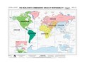
| 描述U.S. Unified Command Plan Map 2008-12-23.png |
English: The world with commanders' areas of responsibility based on the Unified Command Plan 17 December 2008. (National Geospatial-Intelligence Agency map Edition 8 NGA Series 1107. |
| 日期 | |
| 來源 | http://www.defense.gov/pubs/pdfs/MAP12-08.pdf |
| 作者 | National Geospatial-Intelligence Agency |
| 其他版本 |
|

授權條款
| Public domainPublic domainfalsefalse |
This image is a work of the United States National Geospatial-Intelligence Agency or one of its predecessor agencies. As a work of the U.S. federal government, the image is in the public domain.
English ∙ српски / srpski ∙ 日本語 ∙ +/− |
 |
說明
添加單行說明來描述出檔案所代表的內容
在此檔案描寫的項目
描繪內容
23 12 2008
多媒體型式 繁體中文 (已轉換拼寫)
image/png
檔案歷史
點選日期/時間以檢視該時間的檔案版本。
| 日期/時間 | 縮圖 | 尺寸 | 用戶 | 備註 | |
|---|---|---|---|---|---|
| 目前 | 2009年5月28日 (四) 04:57 | | 1,600 × 1,236(1.4 MB) | Sv1xv | {{Information |Description={{en|1=The world with commanders' areas of responsibility based on the Unified Command Plan 17 December 2008. (National Geospatial-Intelligence Agency map Edition 8 NGA Series 1107.}} |Source=[[:File:U.S. Unified Command Plan Ma |
檔案用途
沒有使用此檔案的頁面。
全域檔案使用狀況
以下其他 wiki 使用了這個檔案:
- fr.wikiversity.org 的使用狀況