File:Libya_Montes.jpg
維基百科,自由的 encyclopedia
原始檔案 (2,174 × 987 像素,檔案大小:150 KB,MIME 類型:image/jpeg)
摘要
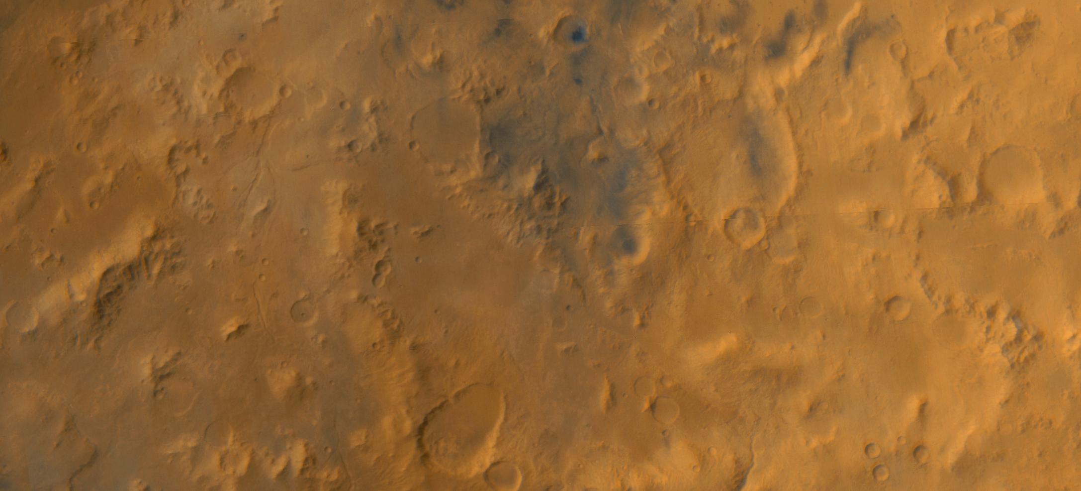
Original Caption Released with Image: The Libya Montes are a ring of mountains up-lifted by the giant impact that created the Isidis basin to the north. During 1999, this region became one of the top two that were being considered for the now-canceled Mars Surveyor 2001 Lander. The Isidis basin is very, very ancient. Thus, the mountains that form its rims would contain some of the oldest rocks available at the Martian surface, and a landing in this region might potentially provide information about conditions on early Mars. In May 1999, the wide angle cameras of the Mars Global Surveyor Mars Orbiter Camera system were used in what was called the "Geodesy Campaign" to obtain nearly global maps of the planet in color and in stereo at resolutions of 240 m/pixel (787 ft/pixel) for the red camera and 480 m/pixel (1575 ft/pixel) for the blue. Shown here are color and stereo views constructed from mosaics of the Geodesy Campaign images for the Libya Montes region of Mars. After they formed by giant impact, the Libya Mountains and valleys were subsequently modified and eroded by other processes, including wind, impact cratering, and flow of liquid water to make the many small valleys that can be seen running northward in the scene. The pictures shown here cover nearly 122,000 square kilometers (47,000 square miles) between latitudes 0.1°N and 4.0°N, longitudes 271.5°W and 279.9°W. The mosaics are about 518 km (322 mi) wide by 235 km (146 mi)high. Red-blue "3-D" glasses are needed to view the stereo image.
Image Credit: NASA/JPL/MSSS
授權條款
| Public domainPublic domainfalsefalse |
| 本作品由NASA創作,屬於公有領域。根據NASA的版權政策:“NASA的創作除非另有聲明否則不受版權保護。”(參見:Template:PD-USGov/zh,NASA版權政策或JPL圖像使用政策) | ||
 |
警告:
|
說明
在此檔案描寫的項目
描繪內容
檔案歷史
點選日期/時間以檢視該時間的檔案版本。
| 日期/時間 | 縮圖 | 尺寸 | 用戶 | 備註 | |
|---|---|---|---|---|---|
| 目前 | 2006年4月12日 (三) 17:25 | | 2,174 × 987(150 KB) | Fabio Bettani | Original Caption Released with Image: The Libya Montes are a ring of mountains up-lifted by the giant impact that created the Isidis basin to the north. During 1999, this region became one of the top two that were being considered for the now-cancele |
檔案用途
下列頁面有用到此檔案:
全域檔案使用狀況
以下其他 wiki 使用了這個檔案:
- en.wikipedia.org 的使用狀況
- es.wikipedia.org 的使用狀況
- it.wikipedia.org 的使用狀況
- pl.wikipedia.org 的使用狀況
- sk.wikipedia.org 的使用狀況
- uk.wikipedia.org 的使用狀況
詮釋資料
此檔案中包含擴展的資訊。這些資訊可能是由數位相機或掃描器在建立時或數位化過程中所加入。
如果此檔案的來源檔案已被修改,一些資訊在修改後的檔案中將不能完全反映出來。
| _error | 0 |
|---|