File:Ireland_amo_2010284_geo.tif
維基百科,自由的 encyclopedia

此 TIF 檔案的 JPG 預覽的大小:436 × 600 像素。 其他解析度:174 × 240 像素 | 349 × 480 像素 | 558 × 768 像素 | 745 × 1,024 像素 | 1,600 × 2,200 像素。
原始檔案 (1,600 × 2,200 像素,檔案大小:4.2 MB,MIME 類型:image/tiff)
摘要
| 描述Ireland amo 2010284 geo.tif |
English: Cloud-free satellite view of Ireland |
| 日期 | |
| 來源 | http://earthobservatory.nasa.gov/IOTD/view.php?id=49687 |
| 作者 | NASA; image taken by the Moderate Resolution Imaging Spectroradiometer (MODIS) on the Aqua satellite |
| 其他版本 |
|
.jpg)
授權條款
| Public domainPublic domainfalsefalse |
| 本作品由NASA創作,屬於公有領域。根據NASA的版權政策:“NASA的創作除非另有聲明否則不受版權保護。”(參見:Template:PD-USGov/zh,NASA版權政策或JPL圖像使用政策) | ||
 |
警告:
|
說明
添加單行說明來描述出檔案所代表的內容
在此檔案描寫的項目
描繪內容
11 10 2010
檔案歷史
點選日期/時間以檢視該時間的檔案版本。
| 日期/時間 | 縮圖 | 尺寸 | 用戶 | 備註 | |
|---|---|---|---|---|---|
| 目前 | 2011年3月18日 (五) 11:14 | 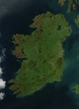 | 1,600 × 2,200(4.2 MB) | Schneelocke | {{Information |Description ={{en|1=Cloud-free satellite view of Ireland}} |Source =http://earthobservatory.nasa.gov/IOTD/view.php?id=49687 |Author =NASA; image taken by the Moderate Resolution Imaging Spectroradiometer (MODIS) on the Aq |
檔案用途
沒有使用此檔案的頁面。
全域檔案使用狀況
以下其他 wiki 使用了這個檔案:
- it.wikibooks.org 的使用狀況
- sc.wikipedia.org 的使用狀況
詮釋資料
此檔案中包含擴展的資訊。這些資訊可能是由數位相機或掃描器在建立時或數位化過程中所加入。
如果此檔案的來源檔案已被修改,一些資訊在修改後的檔案中將不能完全反映出來。
| 寬度 | 1,600 px |
|---|---|
| 高度 | 2,200 px |
| 壓縮方式 | LZW |
| 像素合成 | RGB |
| 方位 | 標準 |
| 像素數量 | 3 |
| 每帶行數 | 54 |
| 水平解析度 | 72 dpi |
| 垂直解析度 | 72 dpi |
| 資料排列 | 矮胖格式 |
| 使用軟體 | Adobe Photoshop CS5 Macintosh |
| 檔案修改日期時間 | 2011年3月16日 (三) 15:43 |
| 色彩空間 | 顏色未校準 |
| warning | wrong data type 13 for "EXIFIFDOffset"; tag ignored. unknown field with tag 33550 (0x830e) encountered. unknown field with tag 33922 (0x8482) encountered. unknown field with tag 34735 (0x87af) encountered. unknown field with tag 34736 (0x87b0) encountered. unknown field with tag 34737 (0x87b1) encountered. |