File:Hungary_geo_divided.jpg
維基百科,自由的 encyclopedia
預覽大小:800 × 499 像素。 其他解析度:320 × 200 像素 | 640 × 400 像素 | 977 × 610 像素。
原始檔案 (977 × 610 像素,檔案大小:98 KB,MIME 類型:image/jpeg)

|
This map has been uploaded by Electionworld from en.wikipedia.org to enable the |
摘要
| 描述Hungary geo divided.jpg |
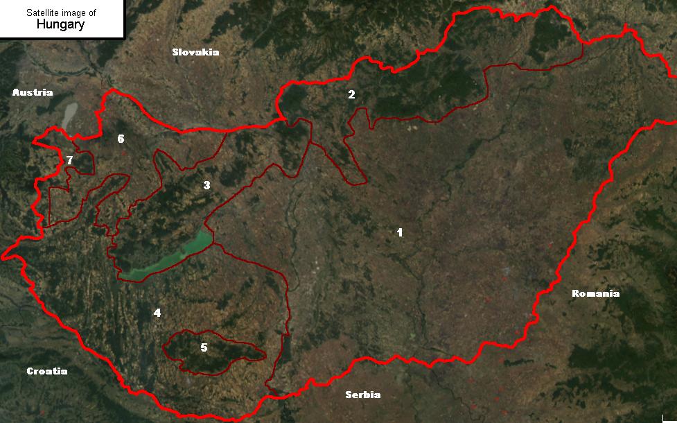
Satellite image of Hungary, with geographical subdivisions. Related: Geography of Hungary. English: Satellite image showing the 7 main geographical regions of Hungary (in parenthesis: mayor region): 1., Great Alföld (Great Alföld) 2., Northern Medium Mountains (Northern Hills) 3., Transdanubian Medium Mountains (Transdanubia) 4., Transdanubian Hills (Transdanubia) 5., Mecsek Mountains (Transdanubia) 6., Little Alföld (Transdanubia) 7., Alpokalja (Transdanubia) |
| 來源 |
|
| 作者 |
授權條款
我,本作品的著作權持有者,決定用以下授權條款發佈本作品:

|
已授權您依據自由軟體基金會發行的無固定段落、封面文字和封底文字GNU自由文件授權條款1.2版或任意後續版本,對本檔進行複製、傳播和/或修改。該協議的副本列在GNU自由文件授權條款中。http://www.gnu.org/copyleft/fdl.htmlGFDLGNU Free Documentation Licensetruetrue |
| 此檔案採用共享創意 姓名標示-相同方式分享 3.0 未在地化版本授權條款。 | ||
| ||
| 已新增授權條款標題至此檔案,作為GFDL授權更新的一部份。http://creativecommons.org/licenses/by-sa/3.0/CC BY-SA 3.0Creative Commons Attribution-Share Alike 3.0truetrue |
- 您可以自由:
- 分享 – 複製、發佈和傳播本作品
- 重新修改 – 創作演繹作品
- 惟需遵照下列條件:
- 姓名標示 – 您必須指名出正確的製作者,和提供授權條款的連結,以及表示是否有對內容上做出變更。您可以用任何合理的方式來行動,但不得以任何方式表明授權條款是對您許可或是由您所使用。
- 相同方式分享 – 如果您利用本素材進行再混合、轉換或創作,您必須基於如同原先的相同或兼容的條款,來分布您的貢獻成品。
您可以選擇您需要的授權條款。
Licensing of the original image:
| Public domainPublic domainfalsefalse |
| 本作品由NASA創作,屬於公有領域。根據NASA的版權政策:“NASA的創作除非另有聲明否則不受版權保護。”(參見:Template:PD-USGov/zh,NASA版權政策或JPL圖像使用政策) | ||
 |
警告:
|
說明
添加單行說明來描述出檔案所代表的內容
在此檔案描寫的項目
描繪內容
共享創意署名-相同方式共享2.5通用版 Chinese (Hong Kong) (已轉換拼寫)
共享創意署名-相同方式共享3.0Unported Chinese (Hong Kong) (已轉換拼寫)
共享創意署名-相同方式共享2.0通用版 Chinese (Hong Kong) (已轉換拼寫)
創用CC姓名標示-相同方式分享1.0通用版 繁體中文 (已轉換拼寫)
GNU自由文檔許可證1.2或更高版本 繁體中文 (已轉換拼寫)
檔案歷史
點選日期/時間以檢視該時間的檔案版本。
| 日期/時間 | 縮圖 | 尺寸 | 用戶 | 備註 | |
|---|---|---|---|---|---|
| 目前 | 2006年12月23日 (六) 23:53 | | 977 × 610(98 KB) | Electionworld | {{ew|en|Cserlajos}} == Summary == Satellite image showing the 7 main geographical regions of Hungary ''(in parenthesis: mayor region)'': <br>1., Great Alföld ''(Great Alföld)''<br>2., Northern Medium Mountains ''(Northern Hi |
檔案用途
下列頁面有用到此檔案:
全域檔案使用狀況
以下其他 wiki 使用了這個檔案:
- be-tarask.wikipedia.org 的使用狀況
- en.wikipedia.org 的使用狀況
- hu.wikipedia.org 的使用狀況
- it.wikipedia.org 的使用狀況
- nn.wikipedia.org 的使用狀況
- no.wikipedia.org 的使用狀況
- pl.wikipedia.org 的使用狀況
- tl.wikipedia.org 的使用狀況
- uk.wikipedia.org 的使用狀況
詮釋資料
此檔案中包含擴展的資訊。這些資訊可能是由數位相機或掃描器在建立時或數位化過程中所加入。
如果此檔案的來源檔案已被修改,一些資訊在修改後的檔案中將不能完全反映出來。
| _error | 0 |
|---|