File:Holy_Roman_Empire_1648.svg
維基百科,自由的 encyclopedia

此 SVG 檔案的 PNG 預覽的大小:756 × 599 像素。 其他解析度:303 × 240 像素 | 606 × 480 像素 | 969 × 768 像素 | 1,280 × 1,015 像素 | 2,560 × 2,030 像素 | 2,283 × 1,810 像素。
原始檔案 (SVG 檔案,表面大小:2,283 × 1,810 像素,檔案大小:3.07 MB)
摘要
| 描述Holy Roman Empire 1648.svg |
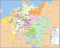
English: Map of the Holy Roman Empire in 1648, after the Peace of Westphalia which ended the Thirty Years' War. Deutsch: Karte des Heiligen Römischen Reiches 1648, nach dem Westfälischer Friede, der den Dreißigjähriger Krieg beendete. Français : Carte du Saint-Empire à 1648, après la paix de Westphalie qui mettent fin à la guerre de Trente Ans. Version française est disponible à File:Holy Roman Empire 1648 fr.svg. Српски / srpski: Мапа Светог римског царства у 1648, након Вестфалског мира којим је завршен Тридесетогодишњи рат.
|
English | Deutsch | Français | Српски |
||
|---|---|---|---|---|---|
| A | Archbishopric | Erzbistum | Archevêché | АДИЈ. | Архидијецеза |
| B | Bishopric | Bistum | Évêché | ДИЈ. | Дијецеза |
| C | County | Grafschaft | Comté | ОКР./ГРОФ. | Округ/грофовија |
| D | Duchy | Herzogtum | Duché | ВОЈВ. | Војводство |
| E | Electorate | Kurfürstentum | Électorat | ЕЛЕКТ. | Електорат |
| L | Landgraviate | Landgrafschaft | Landgraviat | ЛГРОФ. | Ландгрофовија |
| M | Margraviate | Markgrafschaft | Margraviat | МГРОФ. | Маркгрофовија |
| P | Principality | Fürstentum | Principauté | ГРОФ./ОКР. | Грофовија/округ |
Legend / Farblegende / Légende / Легенда
English | Deutsch | Français | Српски |
|
|---|---|---|---|---|
Palatinat des Wittelsbach |
||||
Wittelsbach Bavaria |
Wittelsbacher Bayern |
Bavière des Wittelsbach |
Вителсбах, баварски | |
Hohenzollern Franconia |
Hohenzollerner Franken |
Хоенцолерн, франконски | ||
Wettin Ernestine Saxony |
Wettiner Ernestiner Sachsen |
Saxe de la branche ernestine des Wettin |
Ветин, ернестински | |
InfoField
Made from the public domain map "Central Europe about 1648" from the Historical Atlas by William R. Shepherd, at the Perry-Castañeda Library Map Collection at the University of Texas. Further information from Overy, Richard, 2006, The Times Complete history of the world Times Books ISBN 0007181299, and from this map
See also other maps at external links:
- Central Europe 1648
- Map on personal site, Europe in 1648
- Treaty of Westphalia
- 1648 map of Prussia
- Britannica, Spanish domains in 1648
(重用此檔案)

|
已授權您依據自由軟體基金會發行的無固定段落、封面文字和封底文字GNU自由文件授權條款1.2版或任意後續版本,對本檔進行複製、傳播和/或修改。該協議的副本列在GNU自由文件授權條款中。http://www.gnu.org/copyleft/fdl.htmlGFDLGNU Free Documentation Licensetruetrue |
| 此檔案採用共享創意 姓名標示-相同方式分享 3.0 未在地化版本授權條款。 | ||
| ||
| 已新增授權條款標題至此檔案,作為GFDL授權更新的一部份。http://creativecommons.org/licenses/by-sa/3.0/CC BY-SA 3.0Creative Commons Attribution-Share Alike 3.0truetrue |
[編輯]
-
 英文 SVG
 -
 西班牙文 SVG
 -
 法文 SVG
 -
 喬治亞文 SVG
 -
 塞爾維亞文 SVG
 -
 English: Blank PNG
 -
 英文 PNG
 -
 西班牙文 PNG
 -
 塞爾維亞文 PNG
 -
 俄文 PNG


| This SVG file contains embedded text that can be translated into your language, using any capable SVG editor, text editor or the SVG Translate tool. For more information see: About translating SVG files. |
說明
添加單行說明來描述出檔案所代表的內容
在此檔案描寫的項目
描繪內容
創作作者 Chinese (Hong Kong) (已轉換拼寫)
沒有維基數據項目的某些值
GNU自由文檔許可證1.2或更高版本 繁體中文 (已轉換拼寫)
共享創意署名-相同方式共享3.0Unported Chinese (Hong Kong) (已轉換拼寫)
29 1 2007
多媒體型式 繁體中文 (已轉換拼寫)
image/svg+xml
檔案歷史
點選日期/時間以檢視該時間的檔案版本。
| 日期/時間 | 縮圖 | 尺寸 | 用戶 | 備註 | |
|---|---|---|---|---|---|
| 目前 | 2022年7月24日 (日) 20:43 | | 2,283 × 1,810(3.07 MB) | Maproom | ZWEIBRCKEN -> ZWEIBRÜCKEN, Treves -> Trier, Liege -> Liège |
| 2022年5月18日 (三) 17:55 |  | 2,283 × 1,810(3.07 MB) | Maproom | Consistent, and German, spelling of "Mainz" | |
| 2021年5月25日 (二) 20:11 |  | 2,283 × 1,810(3.07 MB) | ElCet | added the biggest city of Upper Silesia back then | |
| 2018年3月23日 (五) 11:34 |  | 2,283 × 1,810(3.01 MB) | Valentinian | Cleanup some names including missing umlauts. Brunswick-Lüneburg -> Brunswick-Celle (see talk). Border north of Rendsburg seems slightly off to me and the situation in Holstein is rather simplified (jointly administered areas are missing). | |
| 2010年10月8日 (五) 19:09 |  | 2,283 × 1,810(3.01 MB) | Joostik | Ravenstein as part of Cleves | |
| 2009年8月9日 (日) 19:45 |  | 2,283 × 1,810(3.01 MB) | Ysangkok | simplify code (save as plain svg) | |
| 2009年7月14日 (二) 09:24 |  | 2,283 × 1,810(4.17 MB) | Roke~commonswiki | Zusmarshausen | |
| 2007年4月20日 (五) 15:16 |  | 2,283 × 1,810(4.12 MB) | Roke~commonswiki | ||
| 2007年4月20日 (五) 02:04 |  | 2,283 × 1,810(4.11 MB) | Roke~commonswiki | rm HRE text, darken labels | |
| 2007年4月18日 (三) 03:04 |  | 2,283 × 1,810(4.11 MB) | Roke~commonswiki |
檔案用途
全域檔案使用狀況
以下其他 wiki 使用了這個檔案:
- af.wikipedia.org 的使用狀況
- azb.wikipedia.org 的使用狀況
- az.wikipedia.org 的使用狀況
- br.wikipedia.org 的使用狀況
- ca.wikipedia.org 的使用狀況
- ckb.wikipedia.org 的使用狀況
- cs.wikipedia.org 的使用狀況
- el.wikipedia.org 的使用狀況
- en.wikipedia.org 的使用狀況
- Peace of Westphalia
- Thirty Years' War
- Germans
- Wikipedia:WikiProject Maps
- Imperial Estate
- Talk:Paul Skalich
- Treaty of Fontainebleau (1631)
- Wikipedia:Featured picture candidates/Holy Roman Empire in 1648
- Wikipedia:Featured picture candidates/May-2007
- User talk:Giano II/archive 7
- User:Luosiji/Sandbox
- User:Jammydodger/HRE
- Germany in the early modern period
- User:Zealotzuo/Sandbox
- Wikipedia talk:WikiProject Maps/Archive 5
- Territorial evolution of France
- User:Oaholroyd/sandbox
- User:JMvanDijk/Sandbox 10
- User:DyinRich/Something Else
- Aftermath of the Eighty Years' War
- User:Falcaorib/Germany and Prussia
- eo.wikipedia.org 的使用狀況
- et.wikipedia.org 的使用狀況
- fa.wikipedia.org 的使用狀況
- fi.wikipedia.org 的使用狀況
- fy.wikipedia.org 的使用狀況
- hu.wikipedia.org 的使用狀況
- hy.wikipedia.org 的使用狀況
- id.wikipedia.org 的使用狀況
- it.wikipedia.org 的使用狀況
檢視此檔案的更多全域使用狀況。
詮釋資料
此檔案中包含擴展的資訊。這些資訊可能是由數位相機或掃描器在建立時或數位化過程中所加入。
如果此檔案的來源檔案已被修改,一些資訊在修改後的檔案中將不能完全反映出來。
| 寬度 | 2283 |
|---|---|
| 高度 | 1810 |