File:Districts_of_the_Bahamas_(Labeled).png
維基百科,自由的 encyclopedia
預覽大小:578 × 600 像素。 其他解析度:231 × 240 像素 | 463 × 480 像素 | 825 × 856 像素。
原始檔案 (825 × 856 像素,檔案大小:21 KB,MIME 類型:image/png)

|
本圖片是以PNG、GIF或JPEG格式上傳。然而,其中包含的資料或訊息,應該重新建立成可縮放向量圖形(SVG)檔案,以更有效率或更準確的方式儲存。如有可能,請上傳本圖片的SVG格式版本。在上傳之後,請修改維基各姊妹計畫中所有使用舊版圖片的條目(列在圖像連結章節中),替換為新版圖片,並在舊圖片的描述頁中加入{{Vector version available|新圖片名稱.svg}}模板,同時移除本模板。
|
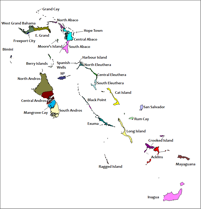
| 描述Districts of the Bahamas (Labeled).png | == Summary == Created by Rarelibra for public domain use. Created using MapInfo Professional v7.5 and referencing various Bahamian map sources. en:Category:Maps of the Bahamas |
| 日期 | (UTC) |
| 來源 | |
| 作者 |
|
| 這是一張修飾過的圖片,即本圖片是用軟體修改過後的版本,修改的方式或內容有:Labells on the various Districts of The Bahamas have been placed.。原版圖片來源:Districts of the Bahamas.png。修改者:Uniongreen113。
|
我,本作品的著作權持有者,決定用以下授權條款發佈本作品:
| Public domainPublic domainfalsefalse |
| 我,此作品的版權所有人,釋出此作品至公共領域。此授權條款在全世界均適用。 這可能在某些國家不合法,如果是的話: 我授予任何人有權利使用此作品於任何用途,除受法律約束外,不受任何限制。 |
原始上傳日誌
This image is a derivative work of the following images:
- File:Districts_of_the_Bahamas.png licensed with PD-self
- 2006-11-05T20:18:13Z Stanmar 825x856 (23099 Bytes) {{Information| |Description= == Summary == Created by [[:en:User:Rarelibra|Rarelibra]] for public domain use. Created using MapInfo Professional v7.5 and referencing various Bahamian map sources. [[:en:Category:Maps of the B
Uploaded with derivativeFX
說明
添加單行說明來描述出檔案所代表的內容
著作權狀態 繁體中文 (已轉換拼寫)
保有知識產權並由其所有者公開於公有領域 繁體中文 (已轉換拼寫)
有著作權 繁體中文 (已轉換拼寫)
著作權持有者釋出至公有領域 繁體中文 (已轉換拼寫)
27 6 2010
多媒體型式 繁體中文 (已轉換拼寫)
image/png
檔案歷史
點選日期/時間以檢視該時間的檔案版本。
| 日期/時間 | 縮圖 | 尺寸 | 用戶 | 備註 | |
|---|---|---|---|---|---|
| 目前 | 2022年6月16日 (四) 16:19 | | 825 × 856(21 KB) | M.Bitton | Per request on en:Wikipedia:Graphics_Lab/Map_workshop#Request_spelling_fix_for_File:Districts_of_the_Bahamas_(Labeled).png |
| 2010年6月27日 (日) 19:54 |  | 825 × 856(36 KB) | Uniongreen113 | {{Information |Description=== Summary == Created by Rarelibra for public domain use. Created using MapInfo Professional v7.5 and referencing various Bahamian map sources. en:Category:Maps of the Bahamas |Source=*[[:File:Distri |
.png)
檔案用途
沒有使用此檔案的頁面。
全域檔案使用狀況
以下其他 wiki 使用了這個檔案:
- az.wiktionary.org 的使用狀況
- en.wikipedia.org 的使用狀況
- eo.wikipedia.org 的使用狀況
- fo.wikipedia.org 的使用狀況
- hu.wikipedia.org 的使用狀況
- id.wikipedia.org 的使用狀況
- is.wikipedia.org 的使用狀況
- it.wikipedia.org 的使用狀況
- la.wikipedia.org 的使用狀況
- lfn.wikipedia.org 的使用狀況
- ms.wikipedia.org 的使用狀況
- pt.wikipedia.org 的使用狀況
- sd.wikipedia.org 的使用狀況
- sv.wikipedia.org 的使用狀況
- tl.wikipedia.org 的使用狀況
- vi.wikipedia.org 的使用狀況
詮釋資料
此檔案中包含擴展的資訊。這些資訊可能是由數位相機或掃描器在建立時或數位化過程中所加入。
如果此檔案的來源檔案已被修改,一些資訊在修改後的檔案中將不能完全反映出來。
| 水平解析度 | 37.8 dpc |
|---|---|
| 垂直解析度 | 37.8 dpc |
.png)