File:Communist_countries.PNG
維基百科,自由的 encyclopedia
預覽大小:800 × 351 像素。 其他解析度:320 × 140 像素 | 640 × 281 像素 | 1,425 × 625 像素。
原始檔案 (1,425 × 625 像素,檔案大小:33 KB,MIME 類型:image/png)
這張圖片需要更新,因為:South Sudan在這樣做的時候,您可以為該圖片加入時間戳。
|

|
File:Communist countries.svg是本檔案的向量版本。 請優先使用那個圖片而非本點陣圖片。
File:Communist countries.PNG → File:Communist countries.svg
更多資訊請參閱Help:SVG/zh。
|
 |
摘要
| 描述Communist countries.PNG |
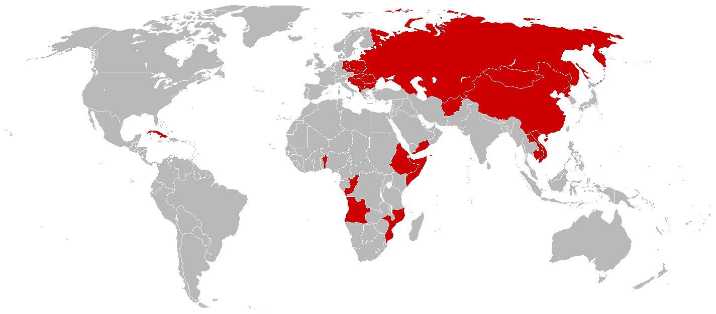
English: An anachronous map of countries (using present-day borders) that have been ruled by a one-party Marxist-Leninist state at some point in their history.
By the time of the 1979-1983 Communist Grenada, all the colored nations above were simultaneously Communist-controlled. |
| 來源 | File:BlankMap-World-1985.png |
| 作者 |
此檔案缺少作者資訊。
|
| 其他版本 | File:Communist countries 1979-1983.png |
授權條款
| Public domainPublic domainfalsefalse |
| 我,此作品的版權所有人,釋出此作品至公共領域。此授權條款在全世界均適用。 這可能在某些國家不合法,如果是的話: 我授予任何人有權利使用此作品於任何用途,除受法律約束外,不受任何限制。 |
說明
添加單行說明來描述出檔案所代表的內容
在此檔案描寫的項目
描繪內容
著作權狀態 繁體中文 (已轉換拼寫)
保有知識產權並由其所有者公開於公有領域 繁體中文 (已轉換拼寫)
著作權持有者釋出至公有領域 繁體中文 (已轉換拼寫)
多媒體型式 繁體中文 (已轉換拼寫)
image/png
資料大小 Chinese (Hong Kong) (已轉換拼寫)
33,544 位元組
625 像素
1,425 像素
檔案歷史
點選日期/時間以檢視該時間的檔案版本。
| 日期/時間 | 縮圖 | 尺寸 | 用戶 | 備註 | |
|---|---|---|---|---|---|
| 目前 | 2014年3月3日 (一) 15:05 | | 1,425 × 625(33 KB) | Hallel | Reverted to version as of 10:22, 8 April 2010 |
| 2012年11月13日 (二) 14:00 |  | 1,425 × 625(56 KB) | Hallel | Adding to Sandinista Nicaragua to the map. See: [http://en.wikipedia.org/wiki/Nicaraguan_Revolution Nicaraguan Revolution] | |
| 2010年4月8日 (四) 10:22 |  | 1,425 × 625(33 KB) | MaGioZal | Added 1979-1983 [http://en.wikipedia.org/wiki/People%27s_Revolutionary_Government Communist Grenada]. | |
| 2010年1月15日 (五) 03:03 |  | 1,425 × 625(26 KB) | MaGioZal | Changed from current borders to 1985 borders, when all the nations colored in red were Communist one-party states. | |
| 2007年12月13日 (四) 17:16 |  | 1,425 × 625(26 KB) | Mahahahaneapneap | pngcrushed | |
| 2007年2月27日 (二) 08:40 |  | 1,425 × 625(90 KB) | Nikodemos | ||
| 2007年1月7日 (日) 00:32 |  | 1,425 × 625(56 KB) | Sesel | new version of previous map with geographic corrections and modifications to more closely conform to the map's description | |
| 2007年1月6日 (六) 23:37 |  | 1,425 × 625(56 KB) | Zanturaeon~commonswiki | Description:A map of Marxist-Leninist single-party "Communist" socialist states and non-Marxist-Leninist, single-party "Communist" socialist states that exist or have existed in the past. The former is in red, the latter is in light-red. Social-democratic | |
| 2007年1月6日 (六) 23:32 |  | 1,425 × 625(56 KB) | Zanturaeon~commonswiki | Description:A map of Marxist-Leninist single-party "Communist" socialist states and non-Marxist-Leninist, single-party "Communist" socialist states that exist or have existed in the past. The former is in red, the latter is in light-red. Social-democratic |
檔案用途
沒有使用此檔案的頁面。
全域檔案使用狀況
以下其他 wiki 使用了這個檔案:
- da.wikipedia.org 的使用狀況
- en.wikibooks.org 的使用狀況
- pt.wikipedia.org 的使用狀況
- ru.wikipedia.org 的使用狀況
- sk.wikipedia.org 的使用狀況
- te.wikipedia.org 的使用狀況
- uk.wikipedia.org 的使用狀況
詮釋資料
此檔案中包含擴展的資訊。這些資訊可能是由數位相機或掃描器在建立時或數位化過程中所加入。
如果此檔案的來源檔案已被修改,一些資訊在修改後的檔案中將不能完全反映出來。
| 水平解析度 | 28.35 dpc |
|---|---|
| 垂直解析度 | 28.35 dpc |