File:Camargue,_Petite_Caramgue_et_Parc_naturel_reg.png
維基百科,自由的 encyclopedia
預覽大小:800 × 441 像素。 其他解析度:320 × 176 像素 | 640 × 353 像素 | 1,024 × 565 像素 | 1,436 × 792 像素。
原始檔案 (1,436 × 792 像素,檔案大小:63 KB,MIME 類型:image/png)
| 描述Camargue, Petite Camargue et Parc naturel reg.png | |||||
| 日期 | revision 2016-11-21 | ||||
| 來源 | Combination of CIA World Factbook map (Image:Fr-map.png) and Demis Map Server (http://www2.demis.nl/mapserver/mapper.asp) data with additional annotations and modifications by self. | ||||
| 作者 | ChrisO, revision by Ulamm (對話) | ||||
| 其他版本 |
File:Camargue map.png (source)
|

說明
添加單行說明來描述出檔案所代表的內容
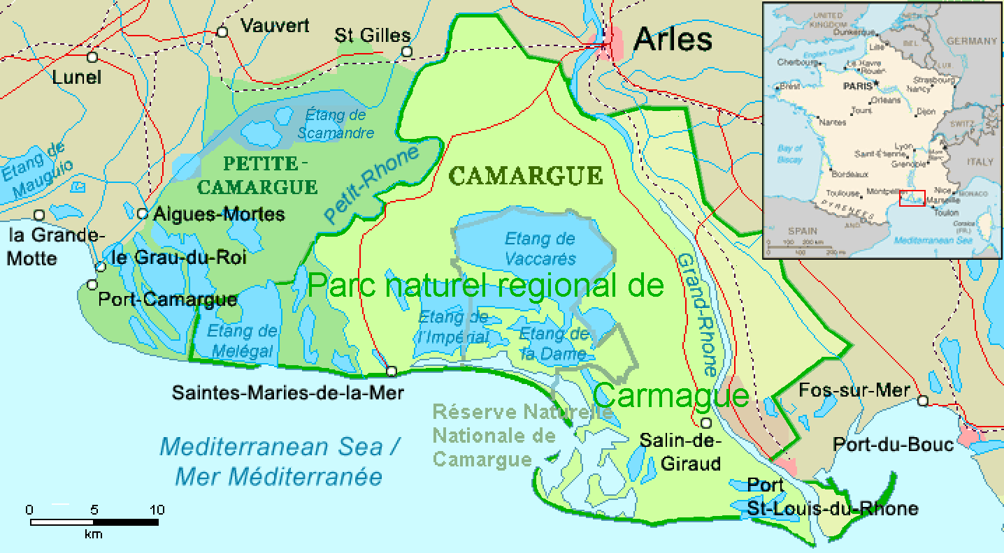
Karte der Camargue-Region im Rhonedelta, Südfrankreich
在此檔案描寫的項目
描繪內容
16 8 2006
多媒體型式 繁體中文 (已轉換拼寫)
image/png
資料大小 Chinese (Hong Kong) (已轉換拼寫)
64,862 位元組
792 像素
1,436 像素
檔案歷史
點選日期/時間以檢視該時間的檔案版本。
| 日期/時間 | 縮圖 | 尺寸 | 用戶 | 備註 | |
|---|---|---|---|---|---|
| 目前 | 2016年12月1日 (四) 01:22 | | 1,436 × 792(63 KB) | Ulamm | name "Grand-Rhône" and the lower courses of Vostre & Vidourle rivers |
| 2016年11月21日 (一) 22:43 |  | 1,436 × 792(63 KB) | Ulamm | {{Information |Description= {{en|Map of the Camargue region, southern France}} |Source=Combination of CIA World Factbook map (Image:Fr-map.png) and Demis Map Server (http://www2.demis.nl/mapserver/mapper.asp) data with additional annotatio... |
檔案用途
下列頁面有用到此檔案:
全域檔案使用狀況
以下其他 wiki 使用了這個檔案:
- ca.wikipedia.org 的使用狀況
- de.wikipedia.org 的使用狀況
- eo.wikipedia.org 的使用狀況
- es.wikipedia.org 的使用狀況
- eu.wikipedia.org 的使用狀況
- fr.wikipedia.org 的使用狀況
- ga.wikipedia.org 的使用狀況
- it.wikipedia.org 的使用狀況
- simple.wikipedia.org 的使用狀況
- uk.wikipedia.org 的使用狀況
- vec.wikipedia.org 的使用狀況
- www.wikidata.org 的使用狀況
詮釋資料
此檔案中包含擴展的資訊。這些資訊可能是由數位相機或掃描器在建立時或數位化過程中所加入。
如果此檔案的來源檔案已被修改,一些資訊在修改後的檔案中將不能完全反映出來。
| PNG 檔案備註 |
|
|---|---|
| 水平解析度 | 56.69 dpc |
| 垂直解析度 | 56.69 dpc |
| 使用軟體 |