File:Attila_in_Gaul_451CE-it.svg
維基百科,自由的 encyclopedia

原始檔案 (SVG 檔案,表面大小:1,283 × 981 像素,檔案大小:392 KB)
摘要
de: Dies ist die deutschsprachige Diagrammversion, andere sind unten angegeben. Das Diagramm zeigt die wahrscheinlichen Wege, die von den Hunnen bei ihrer Invasion Galliens 451 benutzt wurden, und die Schicksale der Städte auf ihrem Weg. Die verschiedenen Quellen ergeben widersprüchliche Information darüber, ob Städte geplündert wurden, insbesondere Trier. Es wird auch gesagt, daß einige Städte südöstlich von Troyes einschließlich Auxerre, Besancon und Langres geplündert wurden.
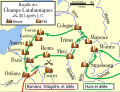
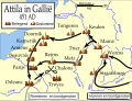
en: An historical map showing the Hun invasion of Gaul in 451 CE (AD), leading to the Battle of Chalons. The generally accepted routes are shown, along with the larger cities threatened or sacked by the Huns.
fr: Une carte historique montrant l'invasion des Huns de la Gaule en 451 Ap J-C, et la bataille des champs Catalauniques. Les itinéraires probables sont montrés, avec les villes plus grandes menacées ou pillées par les huns.
it:Carta storica che descrive l'invasione della Gallia da parte degli Unni nel 451 d.C., e la battaglia dei Campi Catalaunici. Sono mostrati i probabili itinerari, e le città conquistate o risparmiate dagli Unni.
Other versions or similar maps
[編輯]
-
 德文
德文 -
 英文
英文 -
 西班牙文
西班牙文 -
 法文
法文 -
 匈牙利文
匈牙利文 -
 義大利文
義大利文 -
 盧森堡文
盧森堡文 -
 荷蘭文
荷蘭文 -
 葡萄牙文
葡萄牙文 -
 俄文
俄文 -
 中文
中文


References
- Fuller, J.F.C., "The Battle Of Chalons," A Military History of the Western World: From he Earliest Times To The Battle of Lepanto, Da Capo Press, New York, vol. 1. pp. 282-301 ISBN 0-306-80304-6. archive copy at the Wayback Machine
- Attila the Hun and the Battle of Chalons by Arther Ferrill archive copy at the Wayback Machine
- Various other sources including the Catholic Encyclopedia articles on the various cities.
Various sources give conflicting information on whether some cities were sacked, in particular Trier. Man says "no", while Ferrill says "yes". Most other sources agree with Ferrill. There are also several cities southeast of Troyes which were said to have been sacked, including Auxerre, Besancon, and Langres.
In order to be as understandable as possible to the average reader, I have used the modern-day names of the towns, rather than the names used in 451 CE.
授權條款
Original image created by Mapmaster

|
已授權您依據自由軟體基金會發行的無固定段落、封面文字和封底文字GNU自由文件授權條款1.2版或任意後續版本,對本檔進行複製、傳播和/或修改。該協議的副本列在GNU自由文件授權條款中。http://www.gnu.org/copyleft/fdl.htmlGFDLGNU Free Documentation Licensetruetrue |
| 此檔案採用共享創意 姓名標示-相同方式分享 3.0 未在地化版本授權條款。 | ||
| ||
| 已新增授權條款標題至此檔案,作為GFDL授權更新的一部份。http://creativecommons.org/licenses/by-sa/3.0/CC BY-SA 3.0Creative Commons Attribution-Share Alike 3.0truetrue |
說明
在此檔案描寫的項目
描繪內容
GNU自由文檔許可證1.2或更高版本 繁體中文 (已轉換拼寫)
共享創意署名-相同方式共享3.0Unported Chinese (Hong Kong) (已轉換拼寫)
多媒體型式 繁體中文 (已轉換拼寫)
image/svg+xml
資料大小 Chinese (Hong Kong) (已轉換拼寫)
400,910 位元組
981 像素
1,283 像素
檔案歷史
點選日期/時間以檢視該時間的檔案版本。
| 日期/時間 | 縮圖 | 尺寸 | 用戶 | 備註 | |
|---|---|---|---|---|---|
| 目前 | 2007年2月23日 (五) 04:17 | | 1,283 × 981(392 KB) | MapMaster | Changed font for better looking map |
| 2007年2月23日 (五) 04:10 |  | 1,283 × 981(165 KB) | MapMaster | Changed font for better looking map. | |
| 2007年2月22日 (四) 22:32 |  | 1,283 × 981(168 KB) | Triph | Carta storica che descrive l'invasione della Gallia da parte degli Unni nel 451 d.C., e la battaglia dei Campi Catalaunici. Sono mostrati i probabili itinerari, e le città conquistate o risparmiate dagli Unni. |
檔案用途
沒有使用此檔案的頁面。
全域檔案使用狀況
以下其他 wiki 使用了這個檔案:
- fa.wikipedia.org 的使用狀況
- fi.wikipedia.org 的使用狀況
- it.wikipedia.org 的使用狀況