File:Adams_onis_map.png
維基百科,自由的 encyclopedia
預覽大小:733 × 599 像素。 其他解析度:294 × 240 像素 | 587 × 480 像素。
原始檔案 (800 × 654 像素,檔案大小:226 KB,MIME 類型:image/png)

|
File:Adams-Onís treaty map-en.svg是本檔案的向量版本。 如果品質不低,就應該優先使用該檔案,而非PNG檔案。
File:Adams onis map.png → File:Adams-Onís treaty map-en.svg
更多資訊請參閱Help:SVG/zh。
|
 |
摘要
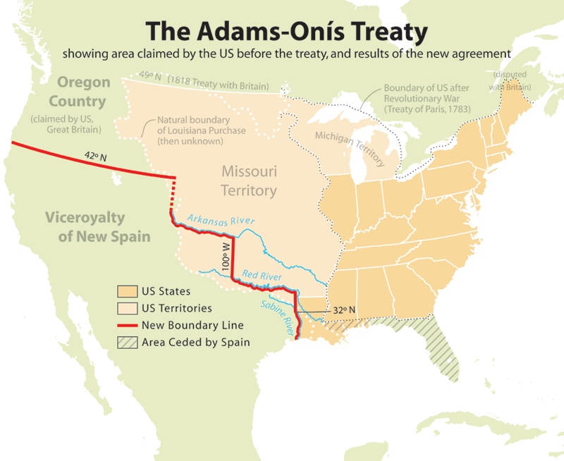
English: Map showing the results of the Adams-Onís Treaty of 1819.
Please state the map from which this was traced, or the other cartographic sources that provided the information allowing you to create the boundaries show.[citation needed]
en:User:Citynoise is the creator at stated at source: I, Citynoise, am the creator of this map and hereby release it per the ShareAlike Attribution license. See www.radicalcartography.net for more.
授權條款
此檔案採用創用CC 姓名標示-相同方式分享 2.5 通用版授權條款。
- 您可以自由:
- 分享 – 複製、發佈和傳播本作品
- 重新修改 – 創作演繹作品
- 惟需遵照下列條件:
- 姓名標示 – 您必須指名出正確的製作者,和提供授權條款的連結,以及表示是否有對內容上做出變更。您可以用任何合理的方式來行動,但不得以任何方式表明授權條款是對您許可或是由您所使用。
- 相同方式分享 – 如果您利用本素材進行再混合、轉換或創作,您必須基於如同原先的相同或兼容的條款,來分布您的貢獻成品。
說明
添加單行說明來描述出檔案所代表的內容
A map showing the results of the Adams-Onis treaty, featuring the land exchanged with Spain
在此檔案描寫的項目
描繪內容
共享創意署名-相同方式共享2.5通用版 Chinese (Hong Kong) (已轉換拼寫)
多媒體型式 繁體中文 (已轉換拼寫)
image/png
資料大小 Chinese (Hong Kong) (已轉換拼寫)
231,585 位元組
654 像素
800 像素
檔案歷史
點選日期/時間以檢視該時間的檔案版本。
| 日期/時間 | 縮圖 | 尺寸 | 用戶 | 備註 | |
|---|---|---|---|---|---|
| 目前 | 2012年7月18日 (三) 18:56 | | 800 × 654(226 KB) | Kmusser | rm Russian claim to Oregon (was dropped by the timeframe of this map - see Adams-Onis talk page) |
| 2006年7月10日 (一) 19:42 |  | 800 × 654(227 KB) | JMPerez~commonswiki | == Summary == Map showing the results of the Adams-Onís Treaty of 1819. I, Citynoise, am the creator of this map and hereby release it per the ShareAlike Attribution license. See www.radicalcartography.net for more. From English Wikipedia. == Licensin |
檔案用途
下列頁面有用到此檔案:
全域檔案使用狀況
以下其他 wiki 使用了這個檔案:
- ar.wikipedia.org 的使用狀況
- ca.wikipedia.org 的使用狀況
- cs.wikipedia.org 的使用狀況
- da.wikipedia.org 的使用狀況
- de.wikipedia.org 的使用狀況
- en.wikipedia.org 的使用狀況
- John Quincy Adams
- James Monroe
- Adams–Onís Treaty
- Moses Austin
- Spanish Canadians
- Spanish Texas
- Presidency of James Monroe
- User:Esemono/British
- Territorial evolution of the Caribbean
- List of territorial claims and designations in Colorado
- Early history of the Arkansas Valley in Colorado
- History of U.S. foreign policy, 1801–1829
- Long's Expedition of 1820
- User:Falcaorib/Canada, United States and Mexico
- eu.wikipedia.org 的使用狀況
- fa.wikipedia.org 的使用狀況
- fi.wikipedia.org 的使用狀況
- he.wikipedia.org 的使用狀況
- hu.wikipedia.org 的使用狀況
- id.wikipedia.org 的使用狀況
- it.wikipedia.org 的使用狀況
- ja.wikipedia.org 的使用狀況
- ko.wikipedia.org 的使用狀況
- nl.wikipedia.org 的使用狀況
- no.wikipedia.org 的使用狀況
- pl.wikipedia.org 的使用狀況
- pnb.wikipedia.org 的使用狀況
- pt.wikipedia.org 的使用狀況
- ro.wikipedia.org 的使用狀況
- ru.wikipedia.org 的使用狀況
- simple.wikipedia.org 的使用狀況
- sr.wikipedia.org 的使用狀況
- sv.wikipedia.org 的使用狀況
- th.wikipedia.org 的使用狀況
- uk.wikipedia.org 的使用狀況
- ur.wikipedia.org 的使用狀況
檢視此檔案的更多全域使用狀況。
詮釋資料
此檔案中包含擴展的資訊。這些資訊可能是由數位相機或掃描器在建立時或數位化過程中所加入。
如果此檔案的來源檔案已被修改,一些資訊在修改後的檔案中將不能完全反映出來。
| 水平解析度 | 28.35 dpc |
|---|---|
| 垂直解析度 | 28.35 dpc |