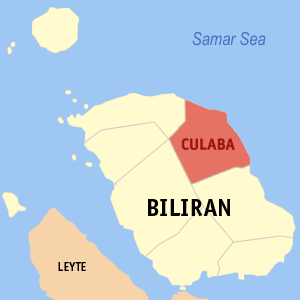
庫拉巴市是菲律賓共和國東米沙鄢大區比利蘭省的第五個自治市,依據2010人口普查數據,該市總人口為12,252人。[4]
| 庫拉巴市 | |
|---|---|
| 自治市 | |
 | |
| 坐標:11°39′28″N 124°32′33″E | |
| 國家 | 菲律賓 |
| 大區 | 東米沙鄢大區 |
| 省份 | 比利蘭省 |
| 政府駐地 | Lone區 |
| 建立日期 | 1953年10月14日 |
| 自治市 | 1954年1月16日 |
| 鎮 | 17 |
| 政府[1] | |
| • 類型 | 自治市 |
| • Mayor | Lorenzo Reveldez ,Jr. (UNA) |
| • Vice-Mayor | Leslie Ann U. Jayme (LP) |
| • SB Members | PEDROSA, JESSE CLYDE(NP)
NILLOS, JOHN GINO(UNA) PUNAY, EDUARDO(LP) FRANCISCO, WIN(UNA) REVELDEZ, RODITO(LP) DAYOHA, JOEY(NPC) REVELDEZ, TITO(IND) GONZAL, ANNALYN(UNA) |
| 面積[2] | |
| • 總計 | 73.42 平方公里(28.35 平方英里) |
| 人口(2010)[3] | |
| • 總計 | 12,252人 |
| • 密度 | 167人/平方公里(432人/平方英里) |
| 時區 | 菲律賓標準時間(UTC+8) |
| 郵政編碼 | 6564 |
| 電話區號 | 53 |
| 網站 | biliranisland.com |
學校
中學
- 國立庫拉巴職業學校
- 布爾國立高中
小學
- 阿克班小學
- 巴科洛德小學
- 筆隆桐小學
- 布爾小學
- 庫拉巴中心學校
- 加里耙岩小學
- 奤不奤小學
- LOOC小學
- 帕塔小學
- 彼得哈根小學d
- 救恩小學
- 聖羅克小學
醫療保健中心
- 庫拉巴社區醫院
- 布爾衛生服務中心
- 巴科洛德健康中心
- 彼得哈根衛生服務中心
行政區劃
庫拉巴在行政上被分為17個鎮,[5]分別是:
- Acaban
- Bacolod
- Binongtoan
- Bool Central
- Bool East
- Bool West
- Calipayan
- Guindapunan
- Habuhab
- Looc
- Marvel
- Patag
- Pinamihagan
- Poblacion(Culaba Central)
- Salvacion
- San Roque
- Virginia
人口統計
| 年份 | 人數 | ±% |
|---|---|---|
| 1990 | 9822 | -- |
| 1995 | 12703 | +4.94% |
| 2000 | 11506 | -2.10% |
| 2007 | 10962 | -0.67% |
| 2010 | 12252 | +4.13%[6] |
參考資料
外部連結
Wikiwand in your browser!
Seamless Wikipedia browsing. On steroids.
Every time you click a link to Wikipedia, Wiktionary or Wikiquote in your browser's search results, it will show the modern Wikiwand interface.
Wikiwand extension is a five stars, simple, with minimum permission required to keep your browsing private, safe and transparent.
