File:Tectonic_plates.png
維基百科,自由的 encyclopedia
預覽大小:800 × 546 像素。 其他解析度:320 × 218 像素 | 640 × 437 像素 | 1,024 × 699 像素 | 1,280 × 874 像素 | 2,560 × 1,747 像素 | 6,740 × 4,600 像素。
原始檔案 (6,740 × 4,600 像素,檔案大小:4.45 MB,MIME 類型:image/png)
摘要
這張圖片需要更新,因為:the source map was updated by the USGS to correct errors. See this discussion: [1]在這樣做的時候,您可以為該圖片加入時間戳。
|
![[1]](/en/File_talk:Plates_tect2_en.svg#Australian_&_Eurasian_Plates_over_Myanmar)
| 描述Tectonic plates.png |
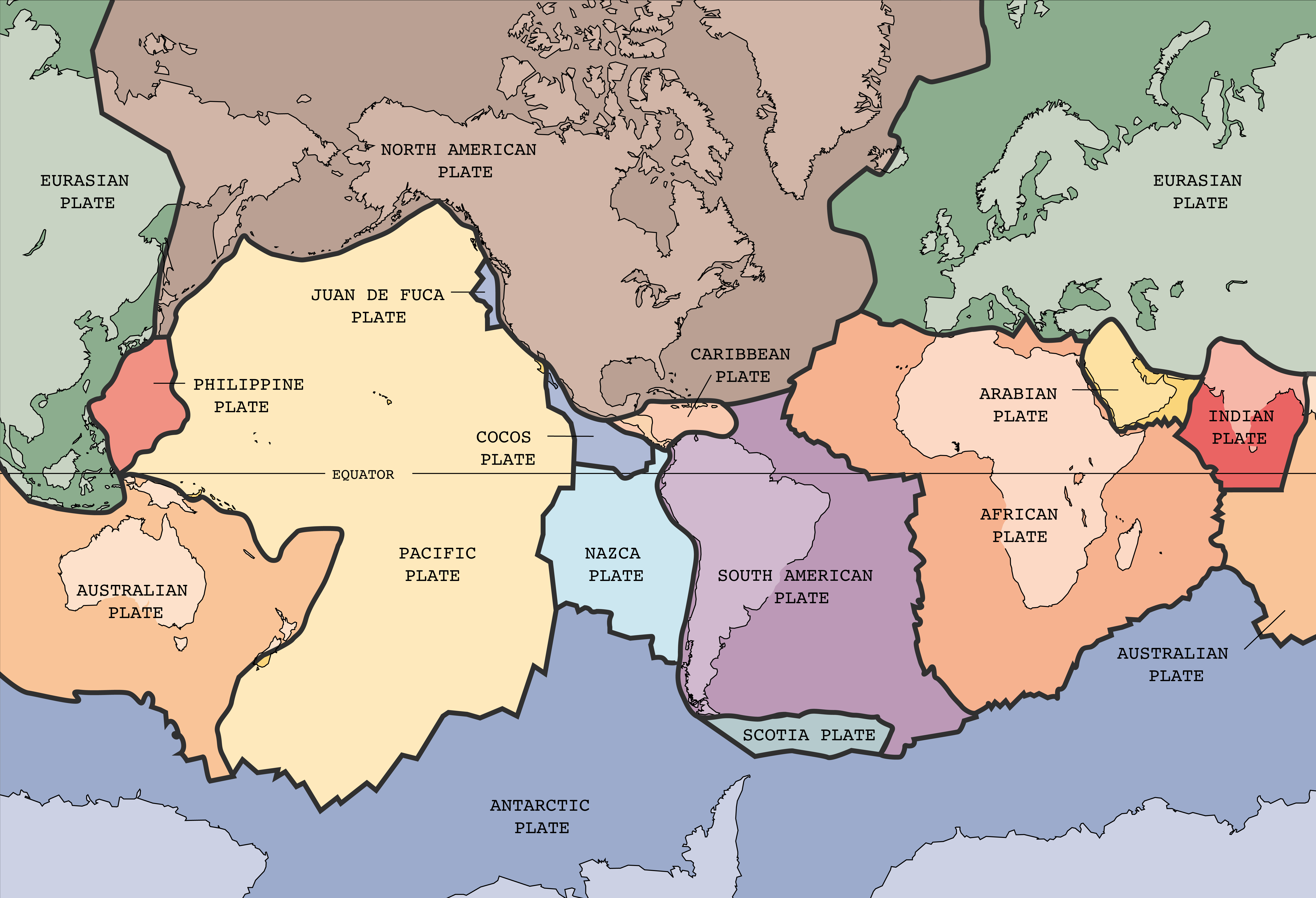
English: English text version of Image:Tectonic plates (empty).svg
Tectonic plates of the Earth. From wikipedia.en, retrieved from USGS site: http://pubs.usgs.gov/publications/text/slabs.html Original Image URL: [3] Listed contact: mailto:jmwatson@usgs.gov
|
| 日期 | 2004年12月30日 (上傳日期) |
| 來源 | [4] |
| 作者 |
|
| 其他版本 |
Derivative works of this file: |
.svg)
.png)
This image was selected as picture of the day on Wikimedia Commons for 20 February 2005. It was captioned as follows: English: Map of the tectonic plates of the Earth Other languages:
Čeština: Mapa tektonických desek Země Deutsch: Karte der tektonischen Platten der Erde English: Map of the tectonic plates of the Earth Español: Mapa de las placas tectónicas de la Tierra. Esperanto: Mapo de la tectonic teleroj de la tero Français : Carte des plaques tectoniques terrestres. Italiano: Mappa delle placche tettoniche della terra Lëtzebuergesch: Kaart vun den tektonesche Placke vun der Äerd. Nederlands: Kaart met de tektonische platen van de aarde Norsk bokmål: Kart over verdas tektoniske plater. Português: Mapa das placas tectônicas da Terra Suomi: Maapallon tektoniset laatat. Svenska: Karta över de tektoniska plattor som täcker jordens yta. Български: Карта на тектоничните плочи на Земята Русский: Карта тектонических плит 日本語: 地球の表面を覆うプレート 中文: 地球板块结构图 |

|
File:Plates tect2 en.svg是本檔案的向量版本。 如果品質不低,就應該優先使用該檔案,而非PNG檔案。
File:Tectonic plates.png → File:Plates tect2 en.svg
更多資訊請參閱Help:SVG/zh。
|
 |
授權條款
| Public domainPublic domainfalsefalse |
|
Bahasa Indonesia ∙ català ∙ čeština ∙ Deutsch ∙ eesti ∙ English ∙ español ∙ français ∙ galego ∙ italiano ∙ Nederlands ∙ português ∙ polski ∙ sicilianu ∙ suomi ∙ Tiếng Việt ∙ Türkçe ∙ български ∙ македонски ∙ русский ∙ മലയാളം ∙ 한국어 ∙ 日本語 ∙ 中文 ∙ 中文(简体) ∙ 中文(繁體) ∙ العربية ∙ فارسی ∙ +/− |
說明
添加單行說明來描述出檔案所代表的內容
在此檔案描寫的項目
描繪內容
30 12 2004
檔案歷史
點選日期/時間以檢視該時間的檔案版本。
| 日期/時間 | 縮圖 | 尺寸 | 用戶 | 備註 | |
|---|---|---|---|---|---|
| 目前 | 2022年2月4日 (五) 03:25 | | 6,740 × 4,600(4.45 MB) | TSamuel | Restored previous version, but losslessly recompressed |
| 2005年10月26日 (三) 20:58 |  | 4,150 × 2,832(3.05 MB) | Dbenbenn | thumbnail, since MediaWiki now refuses to scale PNG images that are more than 12.5 megapixels | |
| 2005年10月26日 (三) 09:40 |  | 6,740 × 4,600(4.96 MB) | Ævar Arnfjörð Bjarmason | Larger version from Image:Tectonic plates large.png | |
| 2004年12月30日 (四) 22:46 |  | 634 × 433(52 KB) | Muriel Gottrop~commonswiki | Tectonic plates |
檔案用途
沒有使用此檔案的頁面。
全域檔案使用狀況
以下其他 wiki 使用了這個檔案:
- ang.wikipedia.org 的使用狀況
- be-tarask.wikipedia.org 的使用狀況
- be.wikipedia.org 的使用狀況
- cv.wikipedia.org 的使用狀況
- en.wikipedia.org 的使用狀況
- en.wikibooks.org 的使用狀況
- fa.wikipedia.org 的使用狀況
- hr.wikipedia.org 的使用狀況
- hy.wikipedia.org 的使用狀況
- hyw.wikipedia.org 的使用狀況
- ia.wikipedia.org 的使用狀況
- is.wikibooks.org 的使用狀況
- ko.wikipedia.org 的使用狀況
- lt.wikipedia.org 的使用狀況
- mn.wikipedia.org 的使用狀況
- pl.wikipedia.org 的使用狀況
- pt.wikipedia.org 的使用狀況
- sl.wikipedia.org 的使用狀況
- sv.wikibooks.org 的使用狀況
- vi.wikipedia.org 的使用狀況
- www.wikidata.org 的使用狀況
詮釋資料
此檔案中包含擴展的資訊。這些資訊可能是由數位相機或掃描器在建立時或數位化過程中所加入。
如果此檔案的來源檔案已被修改,一些資訊在修改後的檔案中將不能完全反映出來。
| 水平解析度 | 28.35 dpc |
|---|---|
| 垂直解析度 | 28.35 dpc |
| 檔案修改日期時間 | 2005年2月19日 (六) 02:29 |