File:Sacajawea_Patera_PIA00485.jpg
維基百科,自由的 encyclopedia
預覽大小:750 × 600 像素。 其他解析度:300 × 240 像素 | 600 × 480 像素 | 960 × 768 像素 | 1,280 × 1,024 像素 | 1,880 × 1,504 像素。
原始檔案 (1,880 × 1,504 像素,檔案大小:696 KB,MIME 類型:image/jpeg)
摘要
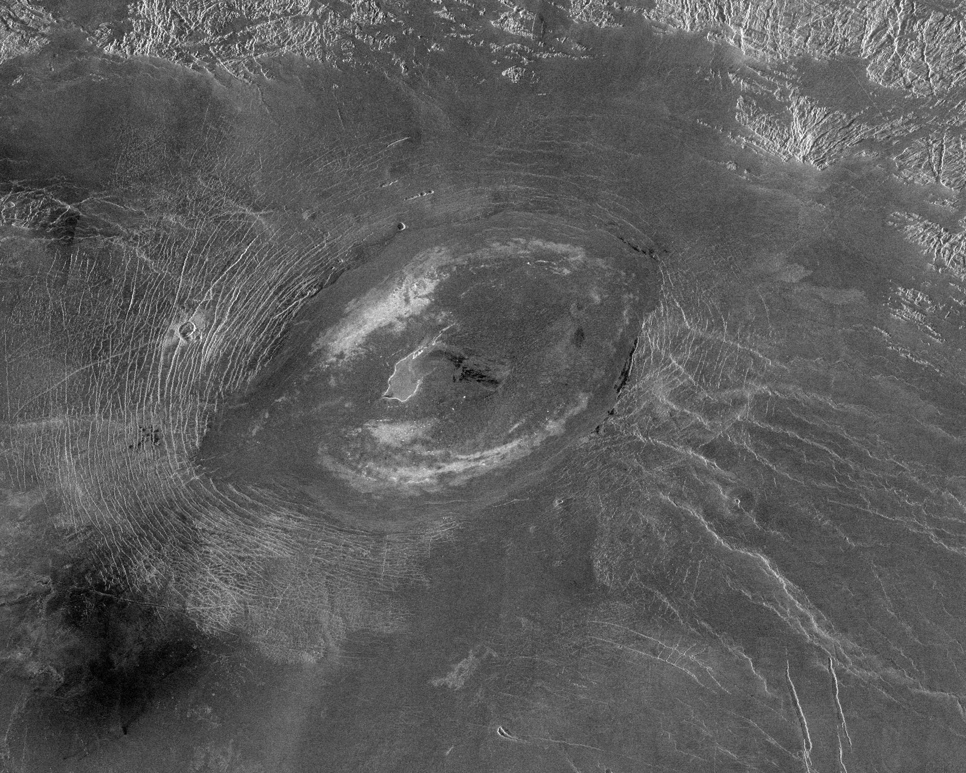
| 描述Sacajawea Patera PIA00485.jpg |
English: This Magellan image reveals Sacajawea Patera, a large, elongate caldera located in Western Ishtar Terra on the smooth plateau of Lakshmi Planum. The image is centered at 64.5 degrees North latitude and 337 degrees East longitude. It is approximately 420 kilometers (252 miles) wide at the base. Sacajawea is a depression approximately 1-2 kilometers (0.6-1.2 miles) deep and 120 x 215 kilometers (74 x 133 miles) in diameter; it is elongate in a southwest-northeast direction. The depression is bounded by a zone of circumferential curvilinear structures interpreted to be graben and fault scarps. These structures are spaced 0.5-4 kilometers (0.3-2.5 miles) apart, are 0.6-4.0 kilometers (0.4-2.5 miles) in width and up to 100 kilometers (62 miles) in length. Extending up to approximately 140 kilometers (87 miles) in length from the southeast of the patera is a system of linear structures thought to represent a flanking rift zone along which the lateral injection and eruption of magma may have occurred. A shield edifice 12 kilometers (7 miles) in diameter with a prominent central pit lies along the trend of one of these features. The impact crater Zlata, approximately 6 kilometers (4 miles) in diameter is located within the zone of graben to the northwest of the patera. Few flow features are observed in association with Sacajawea, possibly due to age and state of degradation of the flows. Mottled bright deposits 4-20 kilometers (2.5-12 miles) in width are located near the periphery and in the center of the patera floor within local topographic lows. Diffuse patches of dark material approximately 40 kilometers (25 miles) in width are observed southwest of the patera, superposed on portions of the surrounding graben. The formation of Sacajawea is thought to be related to the drainage and collapse of a large magma chamber. Gravitational relaxation may have caused the resultant caldera to sag, producing the numerous faults and graben that circumscribe the patera. Regions of complex, highly deformed tessera-like terrain are located north and east of the patera and are seen in the upper portion of the image. |
| 來源 | http://photojournal.jpl.nasa.gov/catalog/PIA00485 |
| 作者 | Magellan probe |
授權條款
| Public domainPublic domainfalsefalse |
| 本作品由NASA創作,屬於公有領域。根據NASA的版權政策:“NASA的創作除非另有聲明否則不受版權保護。”(參見:Template:PD-USGov/zh,NASA版權政策或JPL圖像使用政策) | ||
 |
警告:
|
檔案歷史
點選日期/時間以檢視該時間的檔案版本。
| 日期/時間 | 縮圖 | 尺寸 | 用戶 | 備註 | |
|---|---|---|---|---|---|
| 目前 | 2008年4月6日 (日) 22:02 | | 1,880 × 1,504(696 KB) | Bryan Derksen | {{Information |Description={{en|This Magellan image reveals Sacajawea Patera, a large, elongate caldera located in Western Ishtar Terra on the smooth plateau of Lakshmi Planum. The image is centered at 64.5 degrees North latitude and 337 degrees East long |
檔案用途
下列頁面有用到此檔案:
全域檔案使用狀況
以下其他 wiki 使用了這個檔案:
- cs.wikipedia.org 的使用狀況
- en.wikipedia.org 的使用狀況
- fr.wikipedia.org 的使用狀況
- gl.wikipedia.org 的使用狀況
- nl.wikipedia.org 的使用狀況
- oc.wikipedia.org 的使用狀況
- sr.wikipedia.org 的使用狀況
詮釋資料
此檔案中包含擴展的資訊。這些資訊可能是由數位相機或掃描器在建立時或數位化過程中所加入。
如果此檔案的來源檔案已被修改,一些資訊在修改後的檔案中將不能完全反映出來。
| _error | 0 |
|---|