File:East-Hem_700ad.jpg
維基百科,自由的 encyclopedia
原始檔案 (3,240 × 1,903 像素,檔案大小:924 KB,MIME 類型:image/jpeg)

|
本圖片是以PNG、GIF或JPEG格式上傳。然而,其中包含的資料或訊息,應該重新建立成可縮放向量圖形(SVG)檔案,以更有效率或更準確的方式儲存。如有可能,請上傳本圖片的SVG格式版本。在上傳之後,請修改維基各姊妹計畫中所有使用舊版圖片的條目(列在圖像連結章節中),替換為新版圖片,並在舊圖片的描述頁中加入{{Vector version available|新圖片名稱.svg}}模板,同時移除本模板。
|
 | 這個file中的所有圖片名上傳在JPEG格式,即使它包含非照片數據。該信息可以以PNG或SVG格式更有效或更準確地存儲。 如果可能,請上傳此圖像的PNG或SVG版本,不含壓縮失真,源自非JPEG源(或移除現存的失真)。完成後,請使用{{Superseded|NewImage.ext}}標記JPEG版本並刪除此標記。此標籤不應應用於照片或掃描件。如需更多信息,請參閱{{BadJPEG}}。 |  |
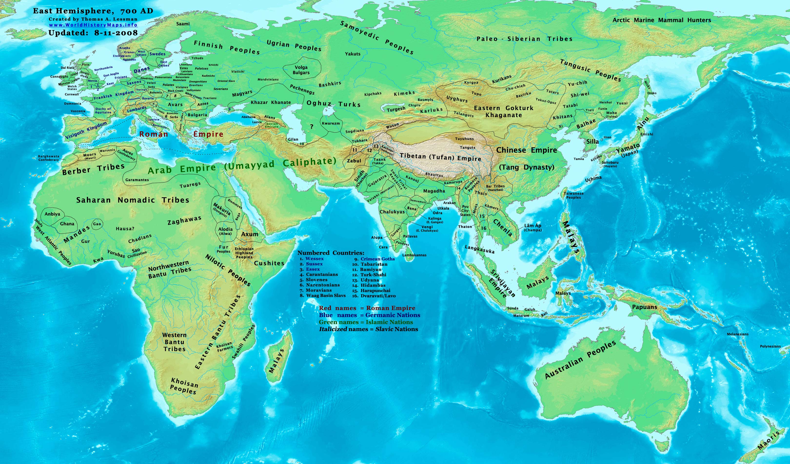
| 描述East-Hem 700ad.jpg | Eastern Hemisphere in 700 AD. |
| 來源 | self-made (For reference information, see the Map Source References section below.) |
| 作者 | Thomas Lessman (Contact!) |
| 授權許可 (重用此檔案) |
我,本作品的著作權持有者,決定用以下授權條款發佈本作品: 此檔案採用共享創意 姓名標示-相同方式分享 3.0 未在地化版本授權條款。
|
| 其他版本 |
Derivative works of this file: Part of East-Hem 700ad.jpg see East-Hem_700ad.jpg file history on Wikipedia. |
Map Summary
Original Source URL: http://www.thomaslessman.com/History/images/East-Hem_700ad.jpg.
This map of the Eastern Hemisphere in 700 AD was created by Thomas Lessman, based on information from the sources listed below. This map is free for educational use (see Permission info above). When using this map, please mention that it is available for free at www.WorldHistoryMaps.info.
Map Source References
- Remember, sources often conflict with each other. This map is only as accurate as the information that is available to me. To report any errors or to help further this work, please click here, or email Thomas Lessman at talessman@yis.us
References for information contained in this map:
1. Borders of Europe are mostly derived from the www.Euratlas.com map of Europe in 700 AD archive copy at the Wayback Machine.
- (Please note: User:Bogomolov.PL has done a great job of showing me possible discrepancies in my north European borders compared to this source, due to the differences in the geographical layout of the maps.)
2. Asian information is mostly derived from the following sources:
- 2a. Wikimedia's World Map 700 CE, created by User:Javierfv1212.
- 2b. Map of Asia in 750 AD, from Huhai.net.
- Please note: borders between Tibet and India are in question due to conflicts between source information:
- 2c. My depiction of Tibet's borders with India are based on these sources:
- 1: DK Atlas of World History (2000 edition, pg. 262), showing Tibet's borders in 800 AD, with northern India (the entire length of the Ganges, almost to the Indus river) under Tibet's control.
- 2: Huhai.net's map of Asia in 750 AD, which shows Tibetan control over Kamarupa, Bengal, and Pala.
- 3: "Himalayan Region, 500–1000 A.D." in Timeline of Art History. New York: The Metropolitan Museum of Art, (October 2001)
- 4: Google Book's "History of Tibet" (Page 54), makes several notes of Nepal's Licchavi dynasty as vassals of Tibet, and also says that India's Pala Empire under King Dharmapala accepted Tibetan overlordship.
- 5: Google Book's "Ancient India", (Page 632), describes Tibetan activities during the reigns of Songtsan Gampo and King Harsha of Kannauj. Also describes the Tibetan subjucation of Kamarupa and Kannauj after the death of King Harsha.
- 6: Wikipedia's article about Tibetan King Songtsän Gampo states that Tibet and Nepal invaded India in 648 AD and defeated Harsha's successor, after the Indian King had attacked a Chinese envoy named Wang Xuanze. (That statement referenced with Stein, R. A. Tibetan Civilization 1962. Revised English edition, 1972, Faber & Faber, London. Reprint, 1972. Stanford University Press, p. 62. ISBN 0-8047-0806-1 cloth; ISBN 0-8047-0901-7 pbk., pp. 58-59)
- Possible alternative borders for Indias Kamarupa, Gauda, Tripura, and Manipur can be seen on User:Porikolpok_Oxom map of Kamarupa 7th-8th Century AD.
3. Fringe areas like Africa, Australia, Siberia, etc. derive from Wikimedia's map of the World Map 700 CE, created by User:Javierfv1212.
4. Much of the information in this map was cross-checked with Bruce Gordon's Regnal Chronologies.
Other Maps by Thomas Lessman
| Maps of the eastern hemisphere showing history
Bold dates are available on Wikimedia or Wikipedia. | ||
| Primeval | ||
| Ancient
|
·| 600 BC | 550 BC | 527 BC | 500 BC |
400 BC | ·| 1 AD | 50 AD | 100 AD | 200 AD | 300 AD | | |
| Medieval |
·| 500 AD | 565 AD | 600 AD | 700 AD | | |
| Modern |
·| 1500 AD | · * For historical maps of the whole world, | |
| history links talk edit view | ||
說明
在此檔案描寫的項目
描繪內容
多媒體型式 繁體中文 (已轉換拼寫)
image/jpeg
檔案歷史
點選日期/時間以檢視該時間的檔案版本。
| 日期/時間 | 縮圖 | 尺寸 | 用戶 | 備註 | |
|---|---|---|---|---|---|
| 目前 | 2022年10月13日 (四) 17:42 | | 3,240 × 1,903(924 KB) | Gyalu22 | Reverted to version as of 20:11, 11 August 2008 (UTC) This is not an ethnic map. |
| 2016年5月6日 (五) 13:37 |  | 3,240 × 1,903(2.33 MB) | Julieta39 | Cosmetic changes according with « Putzger historischer Weltatlas Cornelsen » 1990 - ISBN 3-464-00176-8 ; « Atlas historique Georges Duby » Larousse 1987 - ISBN 2-03-503009-9 ; André & Jean Sellier's « Atlas des Peuples » La Découverte : issues... | |
| 2008年8月11日 (一) 20:11 |  | 3,240 × 1,903(924 KB) | Talessman | {{Information |Description= |Source= |Date= |Author= |Permission= |other_versions= }} | |
| 2008年5月9日 (五) 18:37 |  | 3,240 × 1,903(737 KB) | Talessman | {{Information |Description=Eastern Hemisphere in 700 AD. |Source=self-made |Author=Thomas Lessman |Permission={{self|cc-by-sa-3.0}} }} |
檔案用途
沒有使用此檔案的頁面。
全域檔案使用狀況
以下其他 wiki 使用了這個檔案:
- ar.wikipedia.org 的使用狀況
- arz.wikipedia.org 的使用狀況
- azb.wikipedia.org 的使用狀況
- bar.wikipedia.org 的使用狀況
- be.wikipedia.org 的使用狀況
- bs.wikipedia.org 的使用狀況
- ca.wikipedia.org 的使用狀況
- cs.wikipedia.org 的使用狀況
- da.wikipedia.org 的使用狀況
- de.wikipedia.org 的使用狀況
- en.wikipedia.org 的使用狀況
- 7th century
- 8th century
- 745
- 700
- History of the Khitans
- User:Tompw/sandbox10
- File:Tibet 700ad.jpg
- User:Talessman/Maps
- User talk:Talessman/Maps
- Tibetan Empire
- History of the Great Wall of China
- User:Benjamin Trovato/sandbox
- List of states during the Middle Ages
- List of political entities in the 7th century
- User:Navops47/sandbox10
- Wikipedia:Graphics Lab/Map workshop/Archive/Feb 2018
- User:Falcaorib/Ancient East Hemisphere
- es.wikipedia.org 的使用狀況
- et.wikipedia.org 的使用狀況
- fa.wikipedia.org 的使用狀況
- frr.wikipedia.org 的使用狀況
- fr.wikipedia.org 的使用狀況
- gl.wikipedia.org 的使用狀況
- hi.wikipedia.org 的使用狀況
- hu.wikipedia.org 的使用狀況
- hy.wikipedia.org 的使用狀況
- id.wikipedia.org 的使用狀況
- it.wikipedia.org 的使用狀況
檢視此檔案的更多全域使用狀況。