File:Ant-pen-map-Graham-Coast.PNG
維基百科,自由的 encyclopedia
預覽大小:436 × 599 像素。 其他解析度:175 × 240 像素 | 349 × 480 像素 | 720 × 989 像素。
原始檔案 (720 × 989 像素,檔案大小:256 KB,MIME 類型:image/png)
摘要
| 描述Ant-pen-map-Graham-Coast.PNG |
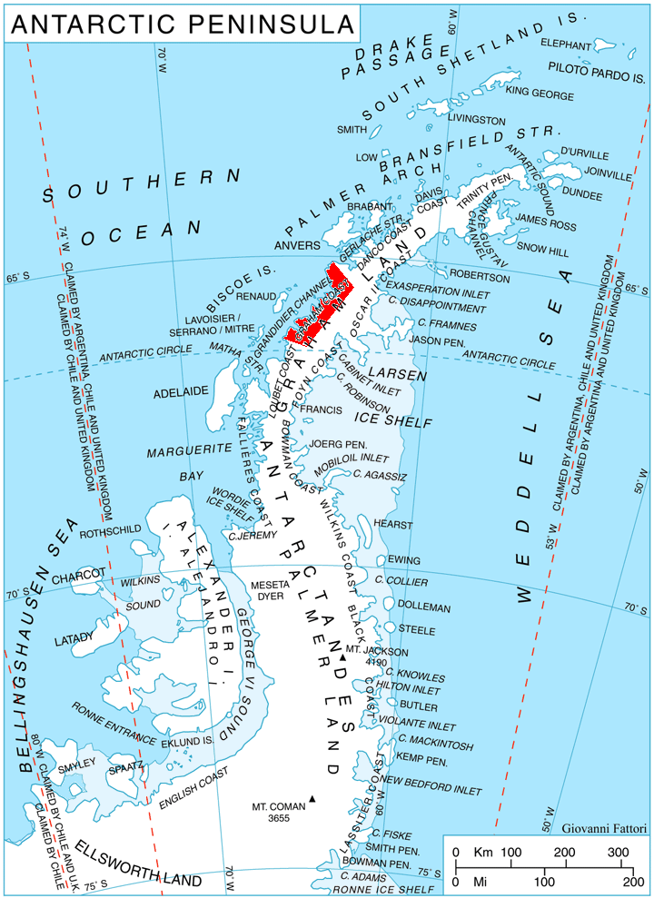
English: Location of Graham Coast, Antarctica. |
| 日期 | |
| 來源 | 自己的作品, using map File:Ant-pen map.png by Giovanni Fattori. |
| 作者 | Edited by Apcbg |
授權條款
我,本作品的著作權持有者,決定用以下授權條款發佈本作品:

|
已授權您依據自由軟體基金會發行的無固定段落、封面文字和封底文字GNU自由文件授權條款1.2版或任意後續版本,對本檔進行複製、傳播和/或修改。該協議的副本列在GNU自由文件授權條款中。http://www.gnu.org/copyleft/fdl.htmlGFDLGNU Free Documentation Licensetruetrue |
此檔案採用創用CC 姓名標示 3.0 未在地化版本授權條款。
- 您可以自由:
- 分享 – 複製、發佈和傳播本作品
- 重新修改 – 創作演繹作品
- 惟需遵照下列條件:
- 姓名標示 – 您必須指名出正確的製作者,和提供授權條款的連結,以及表示是否有對內容上做出變更。您可以用任何合理的方式來行動,但不得以任何方式表明授權條款是對您許可或是由您所使用。
您可以選擇您需要的授權條款。
說明
添加單行說明來描述出檔案所代表的內容
在此檔案描寫的項目
描繪內容
GNU自由文檔許可證1.2或更高版本 繁體中文 (已轉換拼寫)
8 10 2010
多媒體型式 繁體中文 (已轉換拼寫)
image/png
262,010 位元組
989 像素
720 像素
檔案歷史
點選日期/時間以檢視該時間的檔案版本。
| 日期/時間 | 縮圖 | 尺寸 | 用戶 | 備註 | |
|---|---|---|---|---|---|
| 目前 | 2010年10月8日 (五) 16:27 | | 720 × 989(256 KB) | Apcbg | {{Information |Description={{en|1=Location of Graham Coast, Antarctica.}} |Source={{own}}, using map File:Ant-pen map.png by Giovanni Fattori. |Author=Edited by Apcbg |Date=2010-10-08 |Permission= |other_versions= }} [[Category:Maps of |
檔案用途
全域檔案使用狀況
以下其他 wiki 使用了這個檔案:
- bg.wikipedia.org 的使用狀況
- de.wikipedia.org 的使用狀況
- en.wikipedia.org 的使用狀況
- Lawrie Glacier
- Barilari Bay
- Bigo Bay
- Birley Glacier
- Graham Coast
- Cadman Glacier
- Caulfeild Glacier
- Weir Glacier
- Funk Glacier
- Frölich Peak
- Hugi Glacier
- Sphinx Island
- Holtedahl Bay
- Luke Glacier
- Rickmers Glacier
- Larrouy Island
- Leroux Bay
- Lever Glacier
- Chorul Peninsula
- Plas Point
- Nevsha Cove
- Kenderova Buttress
- Chargan Ridge
- Alabak Island
- Mount Radotina
- Strelcha Spur
- Mitino Buttress
- Vardun Point
- Cherkovna Point
- Prestoy Point
- Dodunekov Bluff
- Nauchene Nunatak
- Ezerets Knoll
- es.wikipedia.org 的使用狀況
- eu.wikipedia.org 的使用狀況
- it.wikipedia.org 的使用狀況
- nn.wikipedia.org 的使用狀況
- no.wikipedia.org 的使用狀況
- pl.wikipedia.org 的使用狀況
- pt.wikipedia.org 的使用狀況
- uk.wikipedia.org 的使用狀況
- www.wikidata.org 的使用狀況